


Hiking Mount Agamenticus, York, Maine
Trail Description: The Mount Agamenticus Conservation Region is located in Southern Maine. The Mount Agamenticus Loop is a popular trail that provides 360 degree views at the summit of the surrounding mountains in the distance.
Trail Info:
Where: York, ME Distance: 1.8m (1 hour) Difficulty: Easy toModerate Trail Type: Loop Features: Views, Mountains, Valley
How to get there:
Typing the location “Mount Agamenticus Trailhead” into Google Maps will take you to the parking lot. You can’t miss it. There is a lot of parking. It’s $2/hr to park and there is a barcode to scan for the app to use to pay. It was easy peasy in my opinion. And, worth the money based on how well they keep up with everything.
Coordinates: 43.21720438450835, -70.69198787482621
Link to google maps location here.
Hiking Tips
I suggest caution if it rained days prior. The trails in the forest are mostly roots and rock. Dry it’s no biggie but wet I don’t think it would be as enjoyable.
Download a copy of the trail map here.
There are multiple trail options. This guide is for the loop via Blueberry Bluff, Witch Hazel, and Ring Trail. The Big A trail has separate parking and is a 1 mile loop that’s mostly gravel & an easier option (stroller and wheelchair friendly).
The trail and parking lots are well maintained and great facilities. Nicest outhouse bathrooms I ever been in!

The Hike
Once parked at the Mountain Road parking lot, the beginning of the trail head is visible with markers at end of the parking lot.

There will be trail signs promptly upon starting the hike at a fork. Stay right and hop on the Ring Trail, which is the white marked trail.

As stated prior, the trail is very well marked. However, the trail is mostly rocks and roots. I saw some reviews mentioning that it was muddy and unpleasant after a rainstorm. And, I totally understand what they meant. The rocks and roots could be slippery. For us, it was dry and there were no issues.

There isn’t much of an elevation gain, only about 340 feet. But there is a small incline as you make your way to the top. Hiking along the Ring Trail, at almost 0.7m, there will be a small foot bridge with a path to the left at the end. This is the Witch Hazel trail. I did not see signs but based on the trail map, this was the way to go.

The Witch Hazel trail is brief. Only a few minutes to reach the Big A Trail. There will also be a small foot bridge.

And following the Big A trail at the top is where the first lookout platform is to take in all the views.

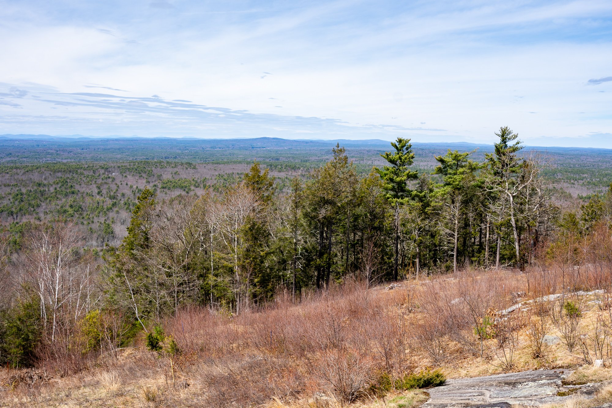
There is another lookout platform with stairs where you can see even higher out into the valley. There is also a fire tower, but it is fenced out and cannot be climbed.


Follow the Big A Trail out until it connects to the Blueberry Bluff, which is marked red. There is also an additional viewpoint here before the Blueberry Bluff.

Continue down the Blueberry Bluff back to the Ring Trail. Take a left at the sign back to the parking lot. You will cross the road at the end to get back to your car.

Southern Maine is tracking to be one of our favorite areas to visit and this was a great first hike in the area. Good hike to get the heart going and see some cool views. The platforms are a cool feature for viewing on the summit. And, the trails and parking lots are so well maintained. I cannot speak highly enough on that. I was not able to find a great guide with details for this hike so I am hopeful this will be helpful for others. It’s also good to see directions/steps before you go to get comfortability. Not a hard hike to follow but I understand where folks can get tripped up. I still do it many times. Luckily, my wife is always the voice of direction.
POST HIKE ACTIVITIES: The fun doesn’t have to stop here. Lots to do in the area. We stopped by the 90s themed brewery, Odd by Nature Brewing, for some post hike beers and nosh, which is about 8 minutes from the trailhead. And, the Nubble Lighthouse is roughly 15 minutes or so away. Definitely a trip to view. Cape Neddick is really cool. Many restaurants in the area as well. No matter what you decide to do, there is a lot to plan for a great weekend or day trip.


HIKING FOR DONUTS
Hi, I’m Mark. I live in Connecticut. I take new trips every chance I get. A good trip has a great hike, great food, and something fun to do. My goal is to search out new trips and share them to inspire others to try something new and exciting.
If you are looking for posts in a particular place, search City or State here.
SEE OTHER POSTS IN ARCHIVE
Archive
RECOMMENDED POSTS
RECENT POSTS


See the latest on Instagram and follow @HIKINGFORDONUTS

Acadia National Park Guide - Best Things to do
Acadia National Park is located along the rocky coastline of Maine and is the only major national park in the northeast. The beauty of the rugged coastline along with the variety of ponds, lakes, forests, and granite peaks are home to some stunning visuals. And, of course, a hiker’s dream with unique and exciting hiking trails that offer breathtaking views or easy strolls along the coastal paths. I can’t believe I waited so long to visit. My national park philosophy is the closer it is, the more opportunities I would have to visit. Thus, I put off Acadia. It took a major life change from a global pandemic for me to make the time to drive up to Acadia. My wife and I decided to take a long weekend trip and visit last October to check out some of the fall foliage. With only a few days to explore, we had an action packed itinerary and were able to enjoy lots of what Acadia National Park has to offer. This guide is based on what we did. However, there is additional info that will give you the tools you need to plan a short or long trip along with some practical tips.
Beehive Trail Summit views
About Acadia National Park
Acadia National Park comprises 3 regions: Mount Desert Island (MDI), Schoodic Peninsula, and Isle au Haut. The majority of the park is located on Mount Desert Island and is the easiest to access from Bar Harbor, the main town where tourists stay. Schoodic Peninsula is the area to visit if you want to get away from the crowds and is about an hour ride from Bar Harbor. Isle au Haut is a remote island only accessible by ferry. It takes a full day to visit Isle au Haut from Mount Desert Island.
The park costs are $30 per car, $25 per motorbike, and $15 per individual coming in on foot, valid for 7 days. Acadia National Park is open year round, however, roads and visitor centers close from late fall to spring.
Travel tip: Stop at the visitor center and get a map. Talk to some rangers to get info on hikes or destinations within the park.
How to Get to Acadia National Park
Acadia National Park is found in Maine’s Mount Desert Island, off the east coast of Maine. The closest city to Acadia National Park is Bar Harbor.
Car: This is the most convenient way to get to the park. And, in my opinion, the best way to travel so you can go wherever you want within the park at your leisure. It is approximately a five-hour drive from Boston, Massachusetts, a three-hour drive from Portland, Maine, and an eight-hour drive from New York City.
Flying: The closest airports to Acadia are as follows:
Hancock County/Bar Harbor Airport (BHB)- 8 miles
Bangor International Airport (BGR)- 50 miles
Portland International Jetport (PWM)- 173 miles
Boston Logan International Airport (BOS)- 274 miles
Travel Tip: If you can not find parking or do not want to have a car, there is a park shuttle that runs during peak season. The shuttle includes stops in Bar Harbor, Hulls Cove Visitor Center, and various places in the park.
When to Visit Acadia National Park
The best time to visit Acadia National Park is in the fall, specifically September and October. This is when the park's gorgeous fall foliage is at full display. This is also one of the busiest times to visit but it is well worth the views and leaf peeping experience.
Summer is a good time to visit but this is the peak season. In addition, there is a higher volume of mosquitoes and ticks. Spring is another good option. Be wary, the weather can change quickly any time due to the park’s far north, coastal location. This can range from rainy to extreme fog to super hot or very cold. Winter is the least favorable option due to shorter days, road closures, facility closings and it’s very cold.
Travel Tip: Currently, during the covid pandemic, this has caused a huge spike in visitors to the U.S. national parks, especially Acadia. Expect the park to be busy, with the exception of winter, as this is the place to go if you are within 8-10 hours driving distance.
Foggy fall foliage at Jordan Pond
Best Things to do in Acadia National Park
Acadia National Park is full of many options for casual tourists, hikers, bikers, climbers, and photographers while visiting. Planning all you want to do can be hard but also the fun part. Here are some recommendations from our long weekend trip.
Views of the The Bowl from Champlain Mountain Trail
Watch the Sunrise or Sunset at Cadillac Mountain
Cadillac Mountain is the first place in the US to view the sunrise and the highest peak on Mount Desert Island. The sunrise over the Atlantic Ocean was a bucket list item for myself but even if you are only able to catch the sunset, the view is breathtaking. This was definitely worth the 3:30am wake up call.
Cadillac Mountain Sunrise
By far, this is the most popular area of the park. Parking is very limited so I recommend getting there at least an hour before sunrise. Once you drive to the top and park, you can just walk around the summit and look for a place to watch. No hiking is involved. However, there is a 0.3 miles trail at the top if you choose to do so. The weather can impact your experience. We dealt with quite a bit of fog all weekend. Due to the higher elevation, fog could block the views. However, the weather decided to cooperate and the skies were clear. And, we were able to see an amazing sunrise.
**IMPORTANT INFO**: This area of the park, you will now need reservations. The National Park Service has implemented a reservation system late-May through mid-October to cut down on traffic on Cadillac Mountain Summit Road. You can find details here on how to make a reservation.
Travel Tip: The top of Cadillac Mountain can be very windy and temperatures are much colder. Pack layers to stay warm and hand warmers, if applicable. Also, we brought head lamps to find a spot to watch since it was dark.
Go Hiking
The hiking trails in Acadia National Park can vary in difficulty, length, and elevation. There is something for all levels of hikers.
Some of the appeal to the hikes in Acadia is the excitement and thrill. There are a large number of trails with ladders and metal rungs. Similar to a via ferrata, you can hike along narrow ledges and climb up sheer rock faces with the help of metal rungs. Hikes that feature iron rungs and cliff walks include the Precipice Trail, the Beehive Trail, the Jordan Cliffs Trail, and the Beech Cliff Ladder Trail. However, if this is not for you, there are plenty of other hikes to choose from.
Starting with the easier hikes in the park, we did the Jordan Pond Loop, which is a 3.4 mile stroll around the Jordan Pond. Combining this with the Bubbles hike is an option. Check out my guide here on the Jordan Pond Loop Trail here.
Jordan Pond and the Bubbles
Other easier hiking trails include: Ocean Path (up to 4 miles or less), South Bubble (1.5m), & Cadillac Mountain Summit Loop (0.3m).
The Gorham Mountain Trail is a good option for a moderate hike. About 1.8 miles with some steep sections. Unfortunately, we were met with nothing but fog at the top. It was a fun hike but no views to show for.
Other moderately strenuous hikes include: Pemetic Mountain (6m), Penobscot and Sargent Mountains (5m) and North Bubble and Conners Nubble (3.5m).
Let’s get crazy. Of course, we had to do the Beehive Trail. Aside from Cadillac Mountain, this is probably the next popular attraction and the most popular hike. This thrilling hike heads up to a steep mountain that features a section with narrow cliff edges, iron rungs to climb up and several handrails for exposed rock scrambling. This spectacular peak overlooks Sand Beach from the northwest. This hike can be very crowded and there can be a log jam using the iron rungs to climb. This hike is very dangerous so please take your time. If you have a fear of heights, this is not for you.
Hiking the Beehive
Due to the shorter time we had to explore, we included The Bowl and Champlain Mountain summit to this hike as well. They can be done separately but make sense to include. Adding these additional trails brought the hike to about 5 miles. The views were amazing. For more specific info on hiking directions, check out my guide here.
Views from the Champlain Mountain Summit
Additional intense hikes to be deemed as difficult options include: Precipice Trail, the Jordan Cliffs Trail, and the Beech Cliff Ladder Trail.
Travel Tip #1: Weather can shift your plans. Be prepared with additional activities or hikes. It might be too foggy for views or the rain might make hiking dangerous. For instance, any hike with iron rungs, I would not suggest to attempt on a rainy day.
Travel Tip #2: If attempting the Beehive Trail, get there early for parking. The Sand Beach parking lot is where you park and fills up very fast.
Drive along Park Loop Road
Park Loop Road is a 27 mile loop that takes you to all the popular destinations in the park. The loop starts at the Hulls Cove Visitor Center. This scenic drive is a great start to an Acadia trip with some viewpoints and turnouts. Some sections can be very narrow and mostly one-way. The most notable stops along the way include:
Sand Beach
Thunder Hole
Otter Cliff
Jordan Pond
Cadillac Mountain (reservation needed)
Travel Tip: Be sure to grab a park map to plan your stops. Since the majority of the road is one way, you can not turn around if you miss something.
Sand Beach
Located on Park Loop Road, it is worth the time to stop at Sand Beach. From here you can hop on the Ocean Path Trail that is an easy walk along the eastern coastline. The trail is 2 miles round trip to Thunder Hole and 4 miles round trip to Otter Point. How far you go is up to you. You could stroll along like us and make some detours to the rocks & turn around.

Travel Tip: The main parking lot to Sand Beach is the biggest in the park. However, this is parking for all the trails listed for Sand Beach and located right across from the start of the Beehive Trail. We found parking around 8am. And, by 9-10am, the lot was full. Getting to popular parking earlier is always the best bet.
Thunder Hole
Thunder Hole is a natural inlet where you can watch waves come crashing against the rocks, creating a thunderous sound. These thunderous crashes are very dependent on the tide. Calm waves or low tide may offer an anticlimactic experience. We are able to hear the crashing noises but nothing too crazy as far as the water height.

Travel Tip: If possible, per research online, the best time to go is about two hours before high tide. Check out the tide charts here.
Jordan Pond House
The Jordan Pond House has been open since the 1890s and is famous for their delicious popovers. We stopped for lunch and other items on the menu as well were delicious. Get the blueberry lemonade, you won’t regret it.

Famous popover and Blueberry Lemonade
Not only is there great food, but there are great views as well. This restaurant is located at the shore of Jordan Pond, where you can take in the views of the North and South Bubbles in the distance. Also, this is where the Jordan Pond Loop Trail can be accessed.
Travel Tip: Parking is tough midday here. There is a small lot at the restaurant and then another bigger lot down the road. However, it is still not enough. We found better success after the lunch crowd after 2pm to enjoy a late lunch post hike. Also, their hours change by season so I would research before you go.
Bass Harbor Head Lighthouse
On the west side of the park, the most popular destination is the Bar Harbor Head Lighthouse. The amazing views of the rocky coastline along with the lighthouse is about as Maine as it gets. And, this setting is what brings so many tourists and photographers to visit. Upon arriving, there is a very, tiny parking lot. Sunset is the best time to come but the absolute busiest time. You will need to get there a few hours before sunset to get a spot. There is a path to the right where you can walk right up to the lighthouse. However, if you want that coastal view, there is a path to the left at the end of the parking lot that takes you down to the rocks.

Sunset at Bass Harbor Head Lighthouse
Travel Tip: Based on my experience, it was about as busy as going to Costco on a Saturday afternoon on a holiday weekend. We got there an hour or so before sunset on a Saturday. Cars were lined up on the narrow road in a log jam and park rangers were turning cars away. I did see people parking even down the road up to almost a mile and walking to it. My wife stayed in the car & I ran down to the path. When I got down to the rocks, there were so many people, it was hard to get a good view. I had to leap rock to rock and ask for people to move out the way to get a picture (politely of course because there was some yelling going on over pictures!). I would suggest going off peak hours or on a weekday if possible.
Schoodic Peninsula and Isle au Haut
We did not get a chance to visit but I would have looked into these other areas of the park if we had more time. Schoodic Point is another great area to see beautiful views of the coastline, with far less of crowds. And remember, Isle Au Haut is only accessible by ferry. Please note that they limit the number of visitors allowed in the Isle au Haut section to protect the environment, so I would suggest stopping by the Hulls Cove Visitor Center to plan ahead.
Carriage Roads
There are 45 miles of car-free carriage roads that run through the park. Here you will find hikers, bikers, and horses along the crushed rock surfaces. There are multiple access points and just another option to enjoy nature in the park.
Explore Bar Harbor
The town of Bar Harbor may be the one of the most exciting towns in the U.S near a National Park. There is so much to do here. This small town is full of great restaurants, bars, and unique shops. Everything is within walking distance and a very safe environment. Also, there are spectacular views of the harbor.
Where to Stay
There are numerous accommodations to stay near Acadia National Park. Airbnbs, bed & breakfasts, and hotels are plenty on Mount Desert Island. Bar Harbor is the closest town with the most going on. If you want to stay a bit farther away from the crowds, there are options in the Northeast Harbor, Bass Harbor, or Southwest Harbor. And, there are campgrounds as well such as: Blackwoods, Seawall, Schoodic Woods, and Duck Harbor Campgrounds.
We stayed at the Island Place, which was affordable and convenient. Walking distance to food and 15 minute ride to the park. Some other options include the Bar Harbor Quality Inn, Bar Harbor Grand Hotel, Bar Harbor Inn & Spa, Shore Path Cottage, and The Elmhurst Inn.
Where to Eat
If you follow this website, you know it’s about travel, hiking, and food. All about finding the good spots to eat and you know I found where to get donuts. With that said, we actually only ate out a few times and packed snacks & lunch (Hannaford’s is right in the center of town in Bar Harbor). We went to Side Street Cafe for dinner, which is very popular. The wait was pretty long but it was an excellent meal. If you want lobster, this is the place. We actually got lobster stew and it was fantastic. For breakfast, we stopped at 2 Cats for some baked goods, breakfast sandwiches, and donuts! Also, they have pretty funny cat puns at all their signs.
Other recommendations based on research to try include: Havana, Atlantic Brewing Company, Jeanine’s Great Maine Breakfast, Docksider, Rosalie’s Pizza, Mount Desert Island Ice Cream, C-Ray Lobster, & Rose Eden Lobster.
If you have any further questions about planning your trip to Acadia National Park, please post in the comment box below.
HIKING FOR DONUTS
Hi, I’m Mark. I live in Connecticut. I take new trips every chance I get. A good trip has a great hike, great food, and something fun to do. My goal is to search out new trips and share them to inspire others to try something new and exciting.
If you are looking for posts in a particular place, search City or State here.
SEE OTHER POSTS IN ARCHIVE
Archive
RECOMMENDED POSTS


RECENT POSTS
See the latest on Instagram and follow @HIKINGFORDONUTS


How to Hike The Beehive Trail, The Bowl, & Champlain Mountain, Acadia National Park
Trail Description: This hike climbs The Beehive via cliffs and iron rungs that leads to The Bowl (a pond), and then climbs up to the summit of Champlain Mountain. There are amazing views from the summits and various spots on the trail.
Trail Info:
Where: Bar Harbor, ME, Acadia National Park Distance: 4.9 miles (5-6 hours) Difficulty: Strenuous Trail Type: Loop Features: Views, Mountains, Water, Pond, Cliffs, Summit
How to get there:
Sand Beach Parking lot in Acadia National Park. There are restrooms here. In addition, there is beach access and other hiking trails.
Hiking Tips
If you have a fear of heights, the Beehive Trail is not recommended for you.
If it has rained recently and the trail is very wet, I would recommend not including the steep climb portion of the Beehive Trail on that day.
Be sure to take this loop trail counter-clockwise. You do not want to climb down the irons rungs nor clog up traffic.
This is the one of the most popular hikes. It will be very busy, start early!
The Hike
The Beehive loop hike at Acadia National Park is probably #1 on most tourists' itinerary. This is a short and steep hike with some exhilarating but dangerous sections using iron rungs to climb up the side of the mountain. The hike is not for the faint of heart. The experience alone makes this a bucket list adventure. So, of course, it was one of my top priorities visiting Acadia for the first time. My wife and I went for a few days last fall. Due to time constraints, I needed to ensure I got the best bang for my buck. Luckily, The Beehive trail intersects with the Bowl which connects to the trail that summits Champlain Mountain. Now, you could do all 3 of these separately but this was a no brainer. This allowed my wife and I to see more amazing views in the allotted time we had.
The trailhead is located on the opposite side of the street, about 100 yards across from the Sand Beach parking lot. From the parking lot, start heading on the gravel path to the right of the parking lot entrance as you walk up to Park Loop Road. Cross the road and the trailhead for the Bowl Trail will be right there. Just follow the crowd! The trail is flat but rocky to start. After 0.2m turn right onto the Beehive Trail where Bowl Trail goes straight. Follow the blue blazed trail.
This is where the climbing begins. First are the short staircases. Then, there are a few narrow ledges with sheer drops. Followed by climbing iron rungs used to assist in the ascent up the vertical rocks. All completely exposed. You have some options here if you are not comfortable going up the Beehive Trail using the iron rungs. There is an option to access The Beehive from the backside or skip it entirely and choose to head to The Bowl. I enjoyed this as it was challenging and thrilling. And, the views were awesome. However, it is not to be taken lightly. It is dangerous. Take your time and be thoughtful to your fellow hikers. This part of the hike is relatively short.


At around 0.6m, we reached the summit of the Beehive Trail and enjoyed some amazing views of Sand Beach and Great Head. The hard work is worth it!
Continuing on the blue blazed trail, go straight through an intersection where a connecting trail leaves left. At 0.9m, this is where we reached the shore of a pond, known as The Bowl.
Follow the path with the wooden boards on the left along the shoreline for 0.1m to split in the trail. The Bowl goes left and Champlain South Ridge Trail will veer to the right. Take the right and follow Champlain South Ridge Trail. The sign indicates 1.6m to Champlain Mountain from here. There is an amazing view of The Bowl as you hike higher up the mountain.
Be weary of the blue markings along the trail and follow the cairns. There are more spectacular views at the summit of Champlain Mountain. This summit is less hectic than the Beehive so this is a good spot to have a snack and relax.


After soaking in the views, retrace your steps down to The Bowl. There are four paths leaving the summit, ensure you are heading the direction you came up. Once you get down to The Bowl intersection, bear right away from the pond and take the rest of the trail back to Park Loop Road for about 0.8m. You will pass two trails on the right leading up to Gorham Mountain and two trails on the left heading to the Beehive. Just keep going straight at all intersections.

This will lead you back to where you started. As mentioned above, we decided to combine all three trails so we can see more. I would highly recommend this particular loop in this fashion. Lots of great views. Amazing hike. The Beehive hype is real. Bucket list checked off.
HIKING FOR DONUTS
Hi, I’m Mark. I live in Connecticut. I take new trips every chance I get. A good trip has a great hike, great food, and something fun to do. My goal is to search out new trips and share them to inspire others to try something new and exciting.
If you are looking for posts in a particular place, search City or State here.
SEE OTHER POSTS IN ARCHIVE
Archive
RECOMMENDED POSTS
RECENT POSTS
See the latest on Instagram and follow @HIKINGFORDONUTS

Best Places to Eat in Portland, Maine
Portland, Maine is one the best foodie towns in the U.S. Every time I visit I find more delicious and creative food spots. The options are endless. Sometimes when visiting such a big food city, it is overwhelming where to start. Don’t worry, I did all the work for you. These are my favorite spots I have stamped with approval. Check out the official Hiking for Donuts food guide to Portland, Maine.
One of my favorite foodie cities to visit is Portland, Maine. There are so many great places to eat. Of course the seafood is fantastic, but the food is much more diverse. Every time I visit, I find new delicious and creative food spots. The choices are endless.And, there are more hits, than misses. My Uber driver said it best, “If it’s not good, it won’t last here.” I haven’t been everywhere, but I think I have done a pretty good job finding some of the best eats in Portland. I assume there will be a part 2 or 3 to this down the road. If you want to eat your way through the city and regret nothing, I got you covered. Enjoy!
Duckfat
One of my favorite restaurants in Portland is Duckfat. This is gluttony at its finest and absolutely fantastic. Hence the name, a lot of items here are cooked in duck fat such as fries, brussel sprouts, donut holes, and even added to a milkshake! With that said, their panini game is top notch. My go to panini is the homemade meatloaf. You heard right. Meatloaf is a heavily underrated dish and they knock it out the park in this sandwich that includes horseradish, pickled onion, cheddar, and smoked poblano mayo between fresh baked bread. So good. The first time I visited Duckfat, I had the meatloaf Panini, duck fat fries, the duck fat milkshake (made with vanilla gelato) and the group sitting next to me offered up some duck fat fried donut holes. I had to go back to the hotel and just lay on the bed directly after the feeding. 100% worth it. Note, the restaurant is pretty small so expect a long wait on busy weekends. This is an absolute must have in Portland.


Empire Chinese Kitchen
I love Chinese cuisine. One of my buddies from Portland suggested Empire Chinese Kitchen for my most recent trip. And, I can’t thank him enough. This spot blew me away. My girlfriend and I went for dinner but it was so packed and the waiting was so long they had to turn us away. I wasn’t leaving without trying so we went first thing the next day when it opened and we got right in. Empire is a family-style restaurant that offers many small plates so you can try multiple dishes. The menu is great and filled with the classics with an upscale take that takes it to another level. We ordered the honey walnut shrimp, lobster rangoons, and duck lo mein. This shrimp was amazing and destroyed any rock shrimp type appetizer I’ve ever had. The lobster Rangoon was the best rangoon I’ve had. And, the duck lo mein was on point. We couldn’t stop there so we ordered their BBQ pork stuffed steam buns and pork fried dumplings. I have been obsessing over finding Bao steamed buns lately and these were money. All the food was great, tasted fresh, and never greasy. My new favorite spot in Portland. Somehow, someway, go to Empire.


Street & Co.
Street & Co. is one of my go to dinner restaurants in Portland. If you want some awesome seafood dishes, this is the place to go. I have never had a bad meal. The pasta dishes are phenomenal. Every time my wife and I go here we order the mussels appetizer, which is a ginormous mound of deliciousness. Maybe the best mussels I ever had. Anywhere we go and get mussels, they are compared to Street & Co.’s version. Dip the bread in the broth after, the thought gets my mouth watering. On our most recent trip, we noticed they offer tuna bolognese (pictured below). Like fresh tuna, not canned. We had to try it out and we were blown away. I kept saying, “I don’t how or why, but I can’t stop eating this”. One of the more unique tasting dishes I have had.
Dutch’s
Breakfast and brunch is a pretty important meal. It’s always great to start the day with a delicious meal. Portland has great breakfast and brunch spots. Luckily for me, my girlfriend found Dutch’s. This place is another Portland gem that has a lot of classics with a twist. They have a more cafeteria style arrangement where you pick your own table and stand in line to order. They have quite a bit of daily/weekly specials to choose from and their own menu is extensive. I chose 10 different items before I got to the counter and went with the Breakfast Burrito. There was special burrito with sausage, eggs, salsa, and hash browns. I pretty much order a breakfast burrito everywhere I go for breakfast and this was one was up there. It was massive and full of flavor. My girlfriend ordered the Spicy Chicken Biscuit sandwich, crispy chicken thigh, avocado mash and a house hot sauce. This was delicious and rivaled to a sandwich you would find in the South. We ordered the loaded hash browns on the side. They have a bunch of baked available which INCLUDES special donut flavors on Saturdays. So, you know I jumped on that. They had Cranberry frosted and Pecan Pie filled. Listen, I love me a classic yeast raised donut that perfectly chewy, not greasy. The Pecan Pie was amazing. Dutch’s knows how to make a great donut. Maybe one of the best in Portland.


The Highroller Lobster Co.
If you want great seafood, Portland is the place for it. And, if you are in Maine and want seafood, you want some lobster. The Highroller Lobster Co. is all about lobster. Their menu consists of lobster rangoons, lobster grilled cheese, fried lobster lollipops, and of course the lobster roll. They have a cool back patio, chill vibe, and dynamite food. Get your lobster fill here.


Luke’s Lobster
Another lobster roll spot to check out is Luke’s Lobster on the Portland Pier. They are the more traditional seafood roll & fried seafood experience. The lobster roll was fresh and delicious. The crab roll was very good as well. They definitely do not skimp on the meat inside in the rolls. Not only is the food great, but the views from the restaurant are pretty awesome too.


Gilbert’s Chowder House
When you are in New England, one of the must have dishes is chowder! All different versions: corn, clam, seafood, New England, Manhattan, etc. Gilbert’s Chowder House was the spot for me. I tried the clam and seafood chowder. Wow, full of flavor and massive chunks of seafood. Look at that lobster!

Mash Tun
Mash Tun is located close to the waterfront in Portland. This is a great, late night hangout spot with an amazing local beer list. They are known for their burgers. I can’t speak to those as of yet. However, sometimes you just need a snack. In between brewery stops, we needed to nibble and we stopped in at Mash Tun and noticed the Cheese Plate. This as reasonably priced so we gave it a shot. The combination of the cheddar cheese, the briny cornichons, sweet apples, pickled onions, chef’s jam, honey Dijon and the bread was what we needed. It is simple but when it all works together, there is nothing like a good cheese plate. I would go back just for this.

Locally Sauced
Upon arriving at Bissell Brothers for my craft beer fix, I was glad to see a new restaurant opened next door. Locally Sauced offers locally sourced ingredients for their menu consisting of nachos, tacos, burritos, and some Tex Mex options. The restaurant is small but they do an order window next to the entrance of Bissell Brothers and you can take the food into the brewery. Of course, after a few beers we were hungry and I ordered some nachos. Now, they do cost $18 but the portion size can easily feed 4-5 adults. This is a great offering to have next to Bissell Brothers.

Bar of Chocolate
If you are looking for a late night martini and a decadent dessert, the Bar of Chocolate is the place to go in Old Port. Choosing from a menu of over a dozen desserts and martinis, you will find an array of chocolate options. We ordered the chocolate cake with sea salt and caramel frosting along with the Peanut Butter martini. The cake was delicious and the drink lived up to expectations. This is a small, cozy location for a great night cap.
Holy Donut
The Holy Donut is a Portland staple, and by far, the most popular donut shop in town. Walking along the harbor on the cobblestone walkway in Old Port, this donut shop is easy to find on weekends. Look for the lines out the door. I have to stop in every time I visit. What makes The Holy Donut unique is that their donuts made with potatoes. Like most cake batter donuts they are dense but also fluffy and moist at the same time. They are fantastic. And, they have some great flavors available such as Sea Salt Chocolate, Maple Bacon, Toasted Coconut, Coffee Cake, and Triple Berry Cannoli to name a few. In addition, they make a Ginger Sweet Potato donut that is unreal. If you want to try these donuts, make sure you get there early. They do tend to sell out. Warning, these donuts are addictive.


Hi-Fi Donuts
On my last trip to Portland, I was excited to hear about a new donut shop that opened called Hi-Fi Donuts. This donut shop offers a different alternative donut option to The Holy Donut, which I think is great. Hi-Fi Donuts offers a wide variety of donuts, flavors, and textures such as crullers, cake, and yeast donuts in very creative flavors along with some classics. In addition, you can order breakfast sandwiches between a glazed donut! There is something to please everyone. My selection included a black and white cruller, blueberry frosted, candied apple swirl, and the hefeweizen (beer yeast). They were super fresh and I enjoyed all the donuts. There are so many options, I can’t wait to go back to try more.
Lil’s Café (Bonus)
If you are driving on I-95N through New Hampshire to Portland, there is a little spot in downtown Kittery that is the perfect pit stop. Lil’s Café offers really good baked goods, soups and sandwiches. They have coffee options as well but we went with some hot chocolate. This was the good stuff. In addition, we ordered a few cruller donuts, which is what they are known for, along with an almond croissant. The almond croissant was mouthwatering. Very flaky and the middle was gooey with almond paste. I wouldn’t pass there baked goods.


HIKING FOR DONUTS
A blog for the outdoors foodie enthusiast
Hi, I’m Mark. I live in Connecticut. I take new trips every chance I get. A good trip has a great hike, great food, and something fun to do. My goal is to search out new trips and share them to inspire others to try something new and exciting.
If you are looking for posts in a particular place, search by city or state here.
EXPLORE OTHER POSTS IN THE ARCHIVE
Archive
RECOMMENDED POSTS

MOST RECENT POSTS
SEE THE LATEST ON INSTAGRAM AND FOLLOW @HIKINGFORDONUTS
Jordan Pond Loop Trail, Acadia National Park
Trail Description: The trail is an easy hike that circles Jordan Pond with many opportunities to explore the shore and observe wonderful views.
Trail Info:
Where: Mount Desert, ME Distance: 3.4m (1.5-2 hours) Difficulty: Easy Trail Type: Loop Features: Views, Mountains, Pond, Water
How to get there:
The Jordan Pond North Parking Lot is located on the left side of Park Loop Rd at the Jordan Pond House. There is another lot next to the restaurant for additional parking as the lot fills up quickly.
https://goo.gl/maps/oQGDyrrCaNHjccsb8
Hiking Tips
Weekends are super crowded. Beware! Parking can be tough.
Post hike, eat at the Jordan Pond House. Get a popover & blueberry lemonade!
The Hike
One of the more iconic landscapes you will see at Acadia National Park is Jordan Pond. If you find yourself in Acadia, this has to be added to your list of things to check out. The shoreline of the pond has amazing views of The Bubbles, two glacially sculpted mountains at the northern end of Jordan Pond. The views are great all times of day, especially sunset and stargazing at night. Not only are the views spectacular, but the rewards of delicious food at the Jordan Pond House is almost worth the visit alone.
This was my very first trip to Acadia. I was not a happy camper to show up to nothing but fog. However, as I am learning, planning trips for national parks is impossible. You take what you can get from mother nature. Even though it was foggy, my wife and I decided to circle Jordan Pond as intended. We did have a few moments where the fog began to lift for some cool views on the pond and a tease of that fall foliage we drove 6.5 hours for! But that dissipated rather quickly. Even so, the eerie look was pretty cool.
The beginning of the trail can be found at the end of the field at the Jordan Pond House. The trail will be split as you approach. We chose to head right to stroll along the east side first. This section of the trail is more level. There are some bridges to cross over the streams that flow into the pond. As we made our way to the left side, there is a dirt trail, boulders, and a wooden plank path through the wetlands. The last 0.5m of the hike was on elevated boards, which I thought was a really cool way to protect the ecosystem. There are various points on the trail where you can hop off and explore the pond's shores. Other than that, the trail is well-marked and pretty self-explanatory.
The other great thing is that you do not need to really hike that entire trail to see some amazing views. The Jordan Pond House practically overlooks the pond. We did not get a chance to eat there the first day so we came back the next day and the weather was beautiful. I walked around the east side again briefly and I was able to see the stunning views I came here for.
Make no mistake, the views are as advertised. BUT do not, at any circumstance, miss out on a popover from the Jordan Pond House. By far, the best meal I have ever had in a national park. That popover with the jam and butter and you have to get the blueberry lemonade, magnifico! We actually tried the bison meatloaf sandwich too. Pretty damn good.
For views like this in a national park, this is as easy as it gets for a hike, or leisurely stroll. The trail is for everyone including children & dogs. It’s a great starter hike to get blood flowing or cool down after some more treacherous trails. This is a classic Acadia hike that should be added to your National Park bucket list. The view of the water with the curves of The Bubbles in the background is quite memorable. And, when you finish, it’s time for a popover!
HIKING FOR DONUTS
Hi, I’m Mark. I live in Connecticut. I take new trips every change I get. A good trip has a great hike, great food, and something fun to do. My goal is to search out new trips and share them to inspire others to try something new and exciting.
If you are looking for posts in a particular place, search City or State here.
SEE OTHER POSTS IN ARCHIVE
Archive
RECOMMENDED POSTS


RECENT POSTS
See the latest on Instagram and follow @HIKINGFORDONUTS