


Ferncliff Forest Fire Tower, Rhinebeck, NY
Trail Description: This is a short hike that brings you to a fire tower with stunning panoramic views of the Catskill Mountains.
Trail Info:
Where: Rhinebeck, NY Distance: 1.4 miles (1 hour) Difficulty: Easy Trail Type: Out & Back Features: Views, Mountains, Water, Pond, River, Fire Tower
How to get there:
68 Mt. Rutsen Road Rhinebeck, NY 12572
https://goo.gl/maps/cXzcj8ZLTL8BxYBh7
Hiking Tips
A busy spot for nice weather and fall foliage.
There are multiple hiking trails in this park, plan your route.

The Hike
From the parking lot, there is a kiosk where you can view the trail map. The yellow-blazed trail starts past the gate. Proceed with the yellow-blazed trail as it inclines gradually along the gravel road. The signage is pretty good on this trail and there are signs to the fire tower.

In about 5 minutes, the trail reaches a pond and there will be a cabin with a sign marked “TOWER” .


And, once you pass the cabin, there is a lean-to that points to the right to continue on the yellow-blazed trail marked “TOWER”. That is the trail you want to be on.

The path continues to climb slowly. There will be another lean-to on the trail and at about another 0.6 miles, the fire tower will be on the left. There are multiple paths that lead to the tower. This is the shortest route. Once my wife and I arrived, there was already a line to go up to the tower. Only 10 people can fit at a time and even that is a stretch. Only family and friend groups were going up.

Once we got up to the top, the panoramic views were amazing! Views of the Hudson River, Catskills, and the Kingston-Rhinecliff Bridge. The fall colors were really popping. This is a great spot for sunset or sunrise. We didn’t get to spend as much time as we wanted up top as we wanted to be considerate to others waiting in line. We returned the same way we came but you could get back to the parking lot a different way.


HIKING FOR DONUTS
Hi, I’m Mark. I live in Connecticut. I take new trips every chance I get. A good trip has a great hike, great food, and something fun to do. My goal is to search out new trips and share them to inspire others to try something new and exciting.
If you are looking for posts in a particular place, search City or State here.
SEE OTHER POSTS IN ARCHIVE
Archive
RECOMMENDED POSTS


RECENT POSTS


See the latest on Instagram and follow @HIKINGFORDONUTS


Mount Beacon Fire Tower, Beacon, NY
Mount Beacon is one of the most popular trails along the Hudson River. It offers different terrain for a good workout, old railway landmarks, and incredible views of the Hudson Valley as well as the Catskills and NYC on a clear day. Most people will hike to the top of the mountain overlooking Beacon. However, adding the fire tower to this hike is worth it. Check out the blog for details and pictures!
Trail Description: Mount Beacon offers gorgeous views of the Hudson Valley and you can see as far as NYC and the Catskills from the fire tower.
Trail Info:
Where: Beacon, NY Distance: 4.4 miles (3-3.5 hours) Difficulty: Moderate Trail Type: Out and Back Features: Views, Hudson River, Fire Tower, Mountains, Valley, Reservoir, Railway
How to get there:
788 Wolcott Ave Beacon, NY 12508
You will see the parking lot located the intersection of Route 9D and Howland Avenue in the City of Beacon. Parking can be limited here. For more info, https://www.scenichudson.org/mountbeacon.
Hiking Tips
Get there early for parking on weekends.
First half mile is the toughest. After that, it’s a breeze. Keep going!
Once you reach the white-blazed trail, take that up to fire tower. The White Trail is not marked as well as the Red Trail, look for faded markings on the rocks.
The Hike
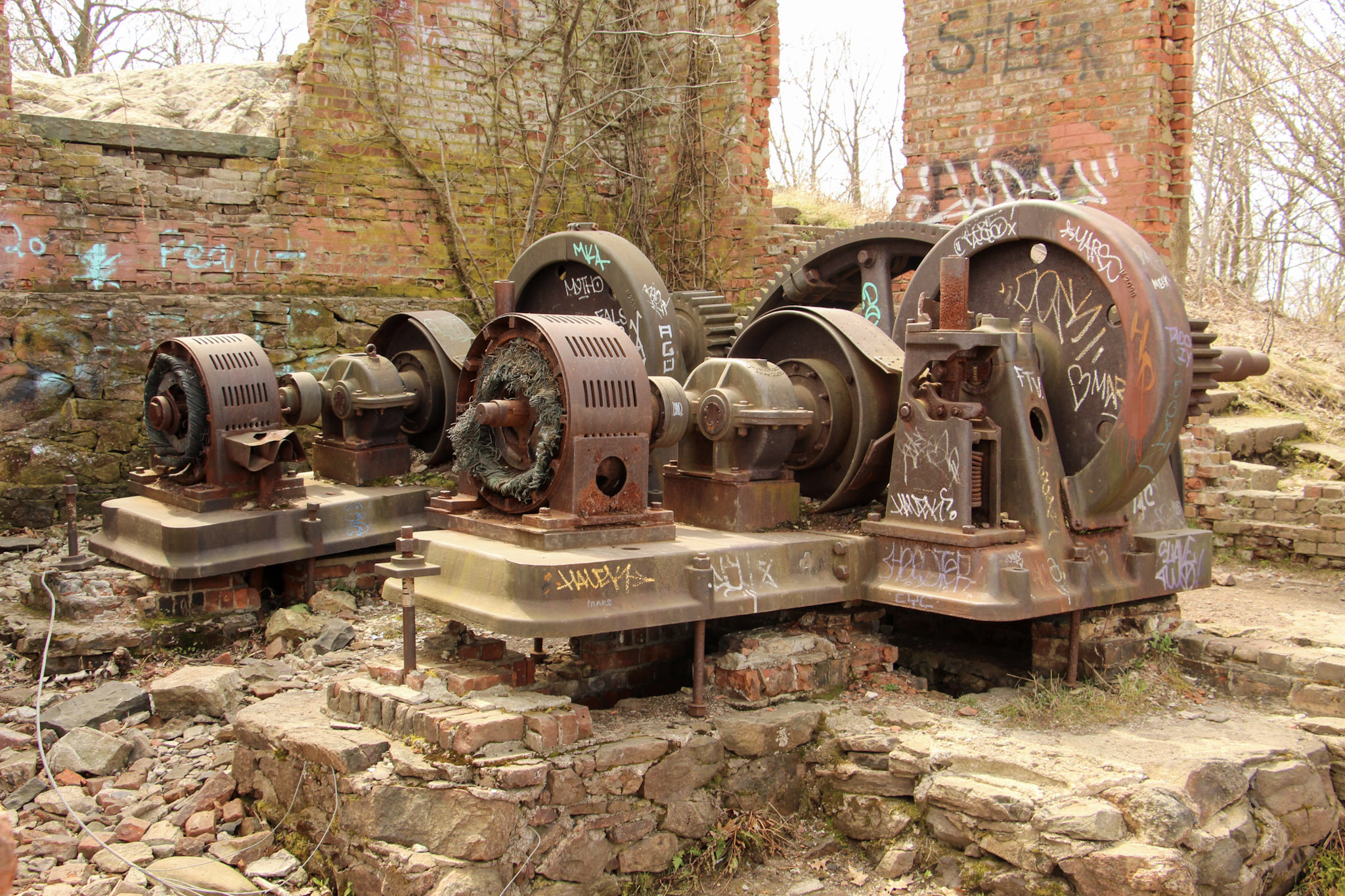
Mount Beacon is one of the most popular trails along the Hudson River. It offers different terrain for a good workout, old railway landmarks, and incredible views. The trail head starts at the parking lot where we found the information kiosk. From here, walk past the wooden gate and proceed along the gravel path on the red-blazed Casino Trail. We arrived at the ruins of the Mount Beacon Incline Railway. The railway was used as a tourist attraction for the views of the Hudson River as well as visiting a Casino Hotel at the top of the mountain in the early 1900s. This was the steepest railway in the world during its operation. Pretty wild! If you want to know more historic details, click here. After passing the ruins, we started making our way up the metal staircase continuing onto the red-blaze trail.
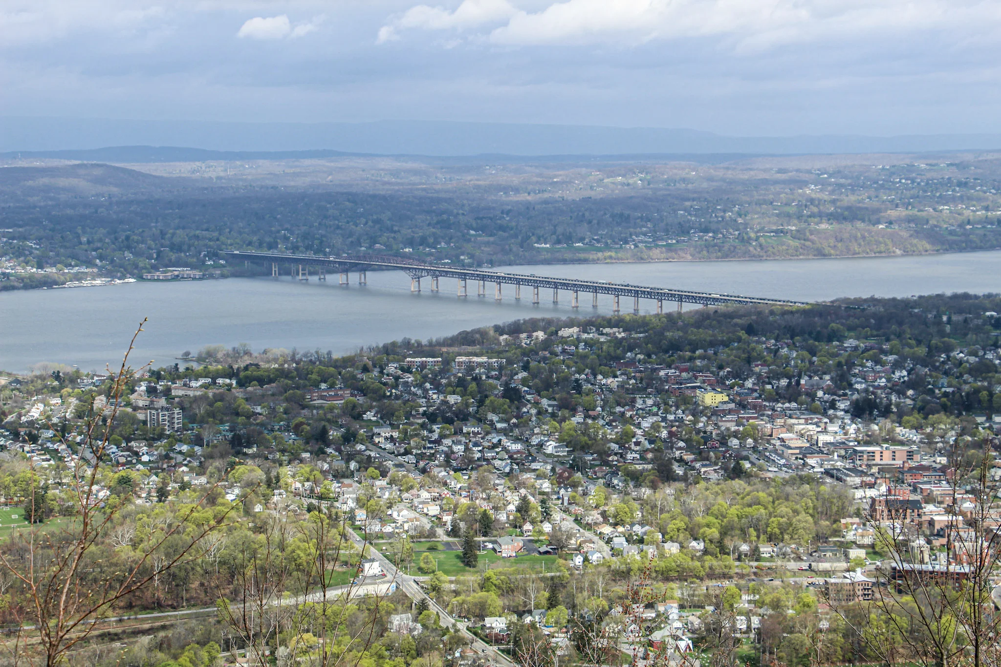
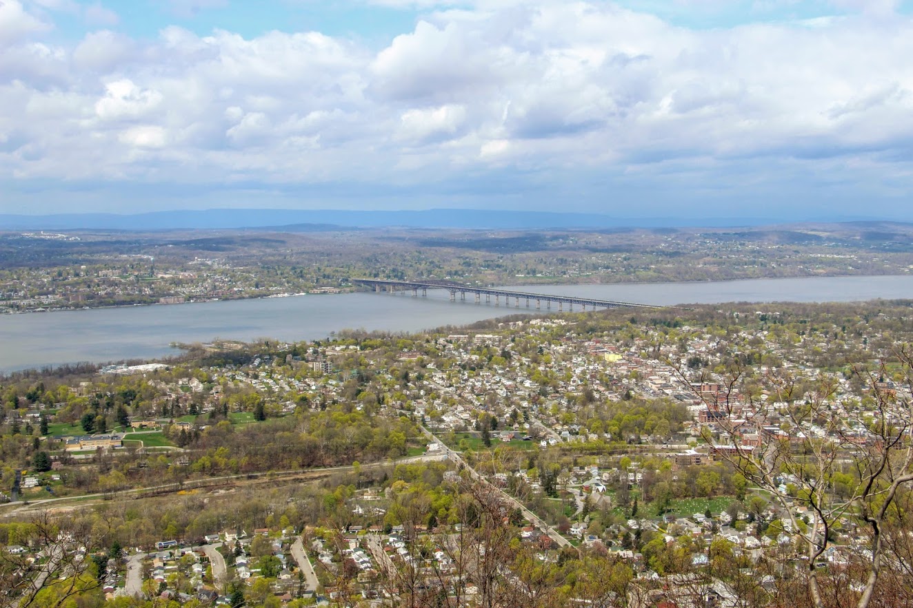
The tough part begins here, only for about a half mile. This is where you see happy faces coming down and not so happy faces going up. The hike will slowly begin to ascend up the mountain following the switchbacks. There may be areas that look unmarked but keep your eyes on the red markings. Eventually, the terrain will become rockier and even steeper uphill. Huffing and puffing our way up, the first glimpse of a view appears as we came up on the first landmark. The motor house of the railway has brick walls still standing and there you will find huge rusted gears and the motor. Past the motor house lies the foundation of what used to be the casino, which is where the first scenic view of the hike can be seen. The view from Mount Beacon stretches across the Hudson with stunning views overlooking Beacon. It is awesome that you can get this view only after hiking just over a mile. The hike started with overcast but amazingly the sky started opened up once we reached the overlook.
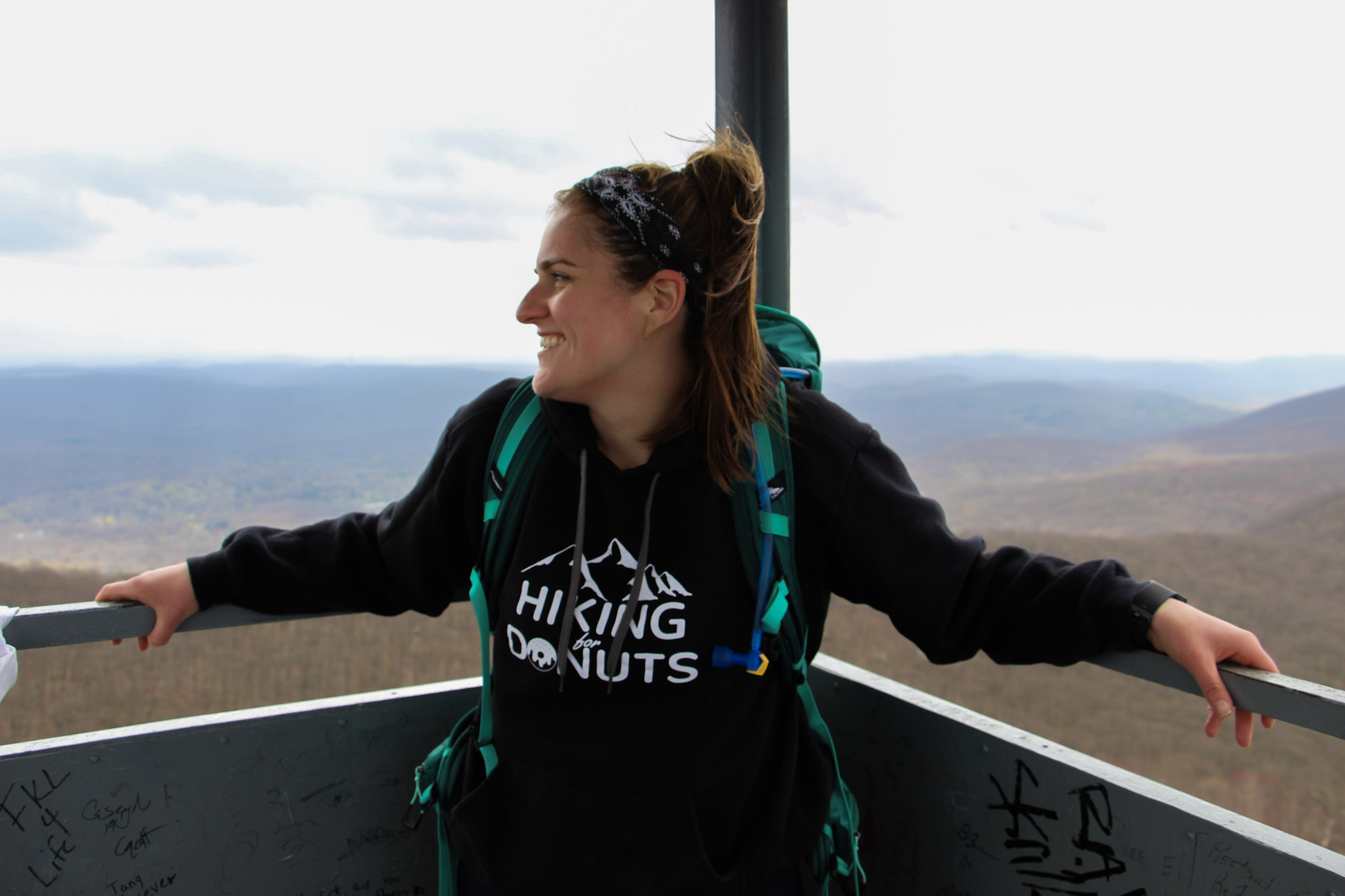
It was time to head toward the fire tower. We turned around from the look out, walked across the old casino ground toward the tower. Eventually, we noticed a red marking on a tree and followed that dirt road through two metal poles and continued on the red-blaze trail. We passed what looks to be a door or frame of an old car or truck on the trail. Additional steep climbing ensued for about 10-15 minutes until there is a clearing with a view of the fire tower. Shortly after, we arrived to the White trail. Before we reached the White Trail, we did notice an unmarked trail leading up the hill toward the fire tower but thanks to research we did not take that path. About 15 minutes later, we found ourselves making our way up the fire tower. This fire tower is pretty high. I was actually getting a bit nervous going up. By this time, the sky opened up completely and the views were an unbelievable 360 view. From the top, you will see Beacon Reservoir and Catskills to your northwest, the Newburgh-Beacon Bridge and Shawangunk Ridge to the west, and, to the south, the southern Hudson Highlands. Even as far down as NYC. And, probably more stuff I don’t even know! My girlfriend had to pry me off the tower. It was super windy but I just kept saying, “This is awesome”. Very fortunate to be able to have access to great hikes like this in the Hudson Valley. Oh, and there’s a donut shop 5 minutes away that is amazing for post hike donuts (Glazed Over Donuts blog post). I cannot recommend this hike enough!
More pics of the hike:


HIKING FOR DONUTS
Hi, I’m Mark. I live in Connecticut. I take new trips every change I get. A good trip has a great hike, great food, and something fun to do. My goal is to search out new trips and share them to inspire others to try something new and exciting.
If you are looking for posts in a particular place, search City or State here.
SEE OTHER POSTS IN ARCHIVE
Archive
RECOMMENDED POSTS


RECENT POSTS
See the latest on Instagram and follow @HIKINGFORDONUTS

Ninham Mountain Fire Tower Hike
Ninham Mountain Fire Tower Trail Guide (Carmel Hamlet, NY)
Hiking Ninham Mountain Fire Tower in NY. Another great Hudson Valley, NY hike. Easy hike, beautiful views.
Trail Description: Ninham Mountain Fire Tower is a short hike that provides an amazing 360 view of rolling hills, lakes, and reservoirs from the top. A glimpse of the Catskills can be visible with clear skies.
Trail Info:
Where: Ninham Mountain Fire Tower, Kent, NY Distance: 1.3 miles (1 hour) Difficulty: Easy Trail Type: Out and Back Features: Fire Tower, Lake, Views, Rolling Hills, Reservoir
How to get there:
As always, do your research on hikes. I read that finding the trail parking was an issue for some hikers. Luckily, I saw that and made sure we had the right directions. We found it pretty easy. It is in the middle of nowhere. The GPS I would enter is Mount Nimham Ct, Carmel Hamlet, NY 10512. This took us on the Taconic State Parkway. Once we were on Gypsy Trail Road, we made another right onto Mt. Nimham Ct. You will see a sign for Ninham Mountain Multiple Use Area. Follow this all the way down until you see the parking lot.
Hiking Tips
Finding the parking lot can be tricky.
The old stone chambers are directly across the parking area. This may be covered by bushes.
The Hike
Traveling through the Hudson Valley area once again, I was in search of a shorter hike. Always need to walk off the beer and donuts from weekend activities. I have a huge list of hikes to do in the area, but my girlfriend and I had some time constraints driving back to CT. Thankful for other hiking bloggers, I came across Ninham Mountain Fire Tower in Kent, NY. The hike was more of a walk with an incline, but the views were fantastic from the fire tower.
Wonder Lake.
Look for these signs at the entrance.
Where the Trail head starts. Parking area is to your left.
The trail head will start behind the gate. Before you even start, don’t miss the old stone chambers directly across the parking lot behind you like we did. We didn’t notice until we were ready to leave. The only reason we had these on our mind was that we read this area was full of paranormal activity. I took my pictures and walked away. I’m no ghost hunter.
Old stone chamber.
Now, onto the hike. Just continue up the gravel road. The trail is uphill but it’s not bad at all. Nothing too difficult but still a good workout. This seemed to be a popular trail for mountain bikers as well. It took us about 15-20 minutes to reach the fire tower.
pretty easy gravel road.
all the way up.
Ninham Mountain FIre Tower
The 360-degree view at the top of the tower was amazing. It was beautiful weather and a clearly visible day. You will see rolling hills, lakes, and reservoirs. The Catskills are also visible in the distance. After you have soaked it all in, you will come back down and walk the same path to your car. Pretty quick and easy. There are some trails you will see off the path but I can’t speak to those.
clear skies and rolling hills.
the money view.

Rolling hills a little closer.
Little overcast on this side of the tower.
Round trip and going up & down the fire tower, this is a total of 1.3 miles. This took us less than a hour. I am glad I came across this spot in my research. If you want the most bang for your buck, this jaunt checks all the boxes including a spectacular view.
HIking for donuts models.

HIKING FOR DONUTS
A blog for the outdoors foodie enthusiast
Hi, I’m Mark. I live in Connecticut. I take new trips every chance I get. A good trip has a great hike, great food, and something fun to do. My goal is to search out new trips and share them to inspire others to try something new and exciting.
If you are looking for posts in a particular place, search by city or state here.
EXPLORE OTHER POSTS IN THE ARCHIVE
Archive
RECOMMENDED POSTS


MOST RECENT POSTS
See where I have been recently on Instagram. Follow @HIKINGFORDONUTS