


Hiking the Breakneck Ridge Trail, New York
Trail Description: The Breakneck Ridge hike is one of the most challenging trails in the Hudson Valley. The mountain is known for rocky terrain, steep rock scrambling, and beautiful views of the Hudson Valley. This trail is immensely popular due to its easy access.
Trail Info:
Where: Cold Spring, NY Distance: 3.7 miles (3.5-4.5 hours) Difficulty: Strenuous Trail Type: Loop Features: Views, River, Mountains, Rock Scrambling
How to get there:
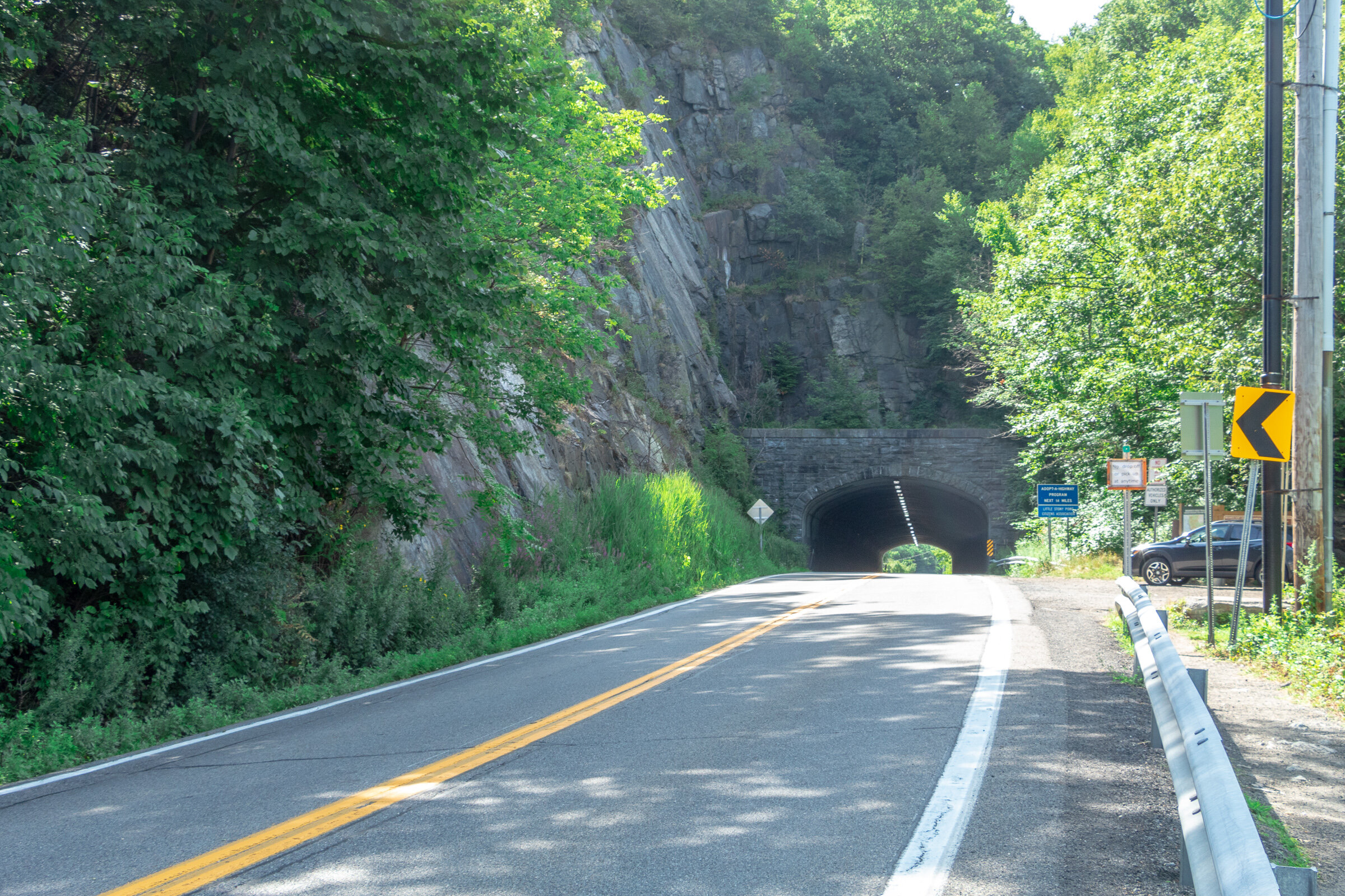
Typing the location “Breakneck Ridge Trailhead” into Google Maps will take you near the parking areas. There are multiple parking spots along State Road 9D, just park where you can north of the tunnel. There is a small lot near the trailhead and a larger lot further down.
For those concerned about parking/driving, this hike is accessible via train. There is a MTA to the Breakneck Ridge train station that is within walking distance to the trail on weekends only.
Hiking Tips
Go on a weekday to avoid the crowds, if possible. Go early on weekends.
Be prepared to rock scramble & use your hands to scale the cliff.
Not dog friendly (unless small dog that you can carry or your dog is a mountain climber)
The Hike
After parking, make sure you are walking along the right hand side of the road. The trailhead starts to the right of the tunnel, where there is trail signage and maps.
There are 3 trail route options for Breakneck Ridge. There is a sign explaining this at the beginning of the trail. The options consist of the short loop (2 hours) ,the regular/classic loop (3 hours), or the trail back to Cold Spring (4 hours). This guide will be the option we took which is the full classic loop.
There is a set of rock stairs that will bring you to the sharp ascent. Follow the white trail markers and start climbing! The terrain on the trail is pretty hard right away. There is a very steep ascent and I needed my hands and knees to get me through this portion of the hike. If you did bring hiking poles, I would suggest securing the poles to your backpack here as they will not be helpful. Depending on your level of climbing up, this can be anywhere from 30 minutes to an hour.

Keep climbing until you reach the flagpole. You will see Pollepel Island with Bannerman’s Castle to your right, along with views of Storm King Mountain straight ahead across the river.


After taking in the views and enjoying a break, continue to follow the white markers as the incline continues. This part is less intense but still some rock scrambling. There is an area in the trail where you can choose to go steeper or take the easier ascent marked with X with an arrow pointing left & right. The easier route was definitely welcomed after the steep climb.

Continue to climb higher and there is another viewpoint with the flagpole far in the distance from above.


Keep climbing until there are no more bluffs and cannot continue further.This is where you head into the forest. The next few miles are much, much easier. You could go back down the way you came but it’s a tough way down and you will be greeted with a traffic jam of many hikers ascending up.

Continue on white markers & ignore the yellow marked trail for now.
There will be a fork eventually. Look for a turn off to the red marked trail (tough to miss red marking on rock). Follow red trail down a gradual descent through woods.

Depending on your pace, the red trail will dead end in about 30-60 minutes where you take left onto yellow trail (Wilkinson Memorial Trail) and keep going downhill and follow all the way to the parking area.


HIKING FOR DONUTS
Hi, I’m Mark. I live in Connecticut. I take new trips every chance I get. A good trip has a great hike, great food, and something fun to do. My goal is to search out new trips and share them to inspire others to try something new and exciting.
If you are looking for posts in a particular place, search City or State here.
SEE OTHER POSTS IN ARCHIVE
RECOMMENDED POSTS


RECENT POSTS


See the latest on Instagram and follow @HIKINGFORDONUTS


Ninham Mountain Fire Tower Hike
Ninham Mountain Fire Tower Trail Guide (Carmel Hamlet, NY)
Hiking Ninham Mountain Fire Tower in NY. Another great Hudson Valley, NY hike. Easy hike, beautiful views.
Trail Description: Ninham Mountain Fire Tower is a short hike that provides an amazing 360 view of rolling hills, lakes, and reservoirs from the top. A glimpse of the Catskills can be visible with clear skies.
Trail Info:
Where: Ninham Mountain Fire Tower, Kent, NY Distance: 1.3 miles (1 hour) Difficulty: Easy Trail Type: Out and Back Features: Fire Tower, Lake, Views, Rolling Hills, Reservoir
How to get there:
As always, do your research on hikes. I read that finding the trail parking was an issue for some hikers. Luckily, I saw that and made sure we had the right directions. We found it pretty easy. It is in the middle of nowhere. The GPS I would enter is Mount Nimham Ct, Carmel Hamlet, NY 10512. This took us on the Taconic State Parkway. Once we were on Gypsy Trail Road, we made another right onto Mt. Nimham Ct. You will see a sign for Ninham Mountain Multiple Use Area. Follow this all the way down until you see the parking lot.
Hiking Tips
Finding the parking lot can be tricky.
The old stone chambers are directly across the parking area. This may be covered by bushes.
The Hike
Traveling through the Hudson Valley area once again, I was in search of a shorter hike. Always need to walk off the beer and donuts from weekend activities. I have a huge list of hikes to do in the area, but my girlfriend and I had some time constraints driving back to CT. Thankful for other hiking bloggers, I came across Ninham Mountain Fire Tower in Kent, NY. The hike was more of a walk with an incline, but the views were fantastic from the fire tower.
Wonder Lake.
Look for these signs at the entrance.
Where the Trail head starts. Parking area is to your left.
The trail head will start behind the gate. Before you even start, don’t miss the old stone chambers directly across the parking lot behind you like we did. We didn’t notice until we were ready to leave. The only reason we had these on our mind was that we read this area was full of paranormal activity. I took my pictures and walked away. I’m no ghost hunter.
Old stone chamber.
Now, onto the hike. Just continue up the gravel road. The trail is uphill but it’s not bad at all. Nothing too difficult but still a good workout. This seemed to be a popular trail for mountain bikers as well. It took us about 15-20 minutes to reach the fire tower.
pretty easy gravel road.
all the way up.
Ninham Mountain FIre Tower
The 360-degree view at the top of the tower was amazing. It was beautiful weather and a clearly visible day. You will see rolling hills, lakes, and reservoirs. The Catskills are also visible in the distance. After you have soaked it all in, you will come back down and walk the same path to your car. Pretty quick and easy. There are some trails you will see off the path but I can’t speak to those.
clear skies and rolling hills.
the money view.

Rolling hills a little closer.
Little overcast on this side of the tower.
Round trip and going up & down the fire tower, this is a total of 1.3 miles. This took us less than a hour. I am glad I came across this spot in my research. If you want the most bang for your buck, this jaunt checks all the boxes including a spectacular view.
HIking for donuts models.

HIKING FOR DONUTS
A blog for the outdoors foodie enthusiast
Hi, I’m Mark. I live in Connecticut. I take new trips every chance I get. A good trip has a great hike, great food, and something fun to do. My goal is to search out new trips and share them to inspire others to try something new and exciting.
If you are looking for posts in a particular place, search by city or state here.
EXPLORE OTHER POSTS IN THE ARCHIVE
RECOMMENDED POSTS

MOST RECENT POSTS
See where I have been recently on Instagram. Follow @HIKINGFORDONUTS