


Garden of the Gods Hiking Guide
Garden of the Gods can be explained in one word: majestic. Colorado is one of my favorite states to travel to and explore. At one time, I visited 3 times out of 4 years. Mostly spending time in Denver, Boulder, and Rocky Mountain National Park. I wanted to see more of the state and my research came across Garden of the Gods. I had to go. And, I immediately included it on my next trip. The park is filled with red rock formations, big and small, overlooking Pike’s Peak and the southern Front Range of the Rockies. It is one of those parks, you have to step your foot in and explore all its beauty. It is 100% percent worth planning your trip around visiting.
About Garden of the Gods
The stunning rock formations throughout the park were created during a geological disruption millions of years ago. The look of the rock you see today is due to subsequent erosion and glaciation. Adding to the park’s distinctiveness, it is also one of the only places in Colorado where you can find red sandstone and Pikes Peak granite together.
Garden of the Gods can be explored by foot, car, or biking with hiking trails and bike lanes throughout the park. There are some wheelchair accessible trails. There are 16 hiking trails that range from 0.25 miles to 6 miles. Most of the trails are relatively easy, but there are a few trails with rockier terrains. And, they connect pretty easily. Rock climbing is another popular activity here as well. There is truly something for everyone at the park.
The visitor center is across from the park itself and is worth a visit to speak to rangers, grab a map, and check out displays and history of the park.
Best of all, the park is FREE. The original owner of the park land, Charles Perkins, wanted to share the experience with everyone. After his passing, his family donated the park to the city to fulfill his wishes. The park is open from dawn until dusk. Check their website for specific hours for the time you are visiting.
How to Get to Garden of the gods
Garden of the Gods is located in Colorado Springs, CO. It is only about 5-10 minutes from the Interstate highway and close to downtown, hotels, shopping, and dining. Traveling from the popular city of Denver will only take just over an hour, which would also make for a great day trip visit. For most out of state explorers, flying into Denver is the best bet and then driving to the park. It is pretty easy to find using your gps.
When to Visit Garden of the gods
The beautiful rock formations and visuals of this park really make any time of the year a feasible time to visit. I went in early May and it was snowing! It was not as warm as expected but the snow made everything look pretty cool. As one would expect, the summer is the busiest time of the year. There is a decent amount of parking but I could see that being filled up by afternoon in the summer/fall time.
Park Entrance
Hiking trails at the Garden of the Gods
There are many hiking trails in the Garden of the Gods. You can’t go wrong with the paths you choose. The park may seem small but you can spend an entire day hiking in the park. The trail system totals up to 15 miles. Here are some of the more popular hikes that offer great sights.
1) The Perkins Central Garden Trail is an easy, 1.5 mile round trip path with minimal elevation. This trail is in the heart of the Park at the base of the highest rock formations. This trail is right near the North Main Parking lot.

Perkins Central Garden path
2) The Ridge Trail is a moderate, 1/2 mile loop with less than a 100 feet in elevation. This trail starts at South Garden Parking Lot and head towards the Sleeping Giant formation to hop on the trail.
3) The Siamese Twins Trail is an easy 1-mile round trip, with less than 150 feet in elevation. On a clear day, there is a fascinating view of Pikes Peak through the natural window of the Siamese Twins. This can be found near the southwest entrance of the park.
Siamese Twins
No views of Pike Peak on this day!
4) The Scotsman/Buckskin Charlie Trail are moderate trails located in the Central Valley of the park that loop through the park. There is a small parking lot to join the Scotsman Loop. It is best to start hiking from the main parking lot and connect to this trail. This area is more open and you can see distant views of the Central Garden formations.
5) The Palmer Trail is a rocky trail that runs along the north and west sides of the park from the North Main Parking Lot to the middle of the Siamese Twins hiking trail. On this trail, there will be more greenery to see and elevated views overlooking Gateway Rock. This is one of the longer hiking trails in the park.
Views from Palmer Trail
6) Choose multiple trails and make your own hiking adventure. It is very easy to connect trails at the park. When I arrived at the park, I went to the visitor center, spoke with a ranger, and grabbed a map. The ranger said the most popular hike in the park to get as many views as possible was taking the 2.7 mile loop starting on the Palmer Trail behind the North Main Parking Lot. From here, you will reach the Siamese Twins Trail and explore this area. Then cross Juniper Way at the Scotsman Picnic Area and hop on the Scotsman Trail. This will lead to the Perkins Central Garden Trail to finish the loop up to the North Main Parking Lot. That is what I did on my visit and I was able to see all the popular rock formations. And, it was a fun and awesome experience exploring amidst all the rock formations.
Hiking Tips: Due the elevation, bring lots of water and keep hydrated to avoid any affects. On those sunny days, be sure to bring sunscreen as there is no shade here. Lastly, as you would expect, come early to visit the park or try the off-season.


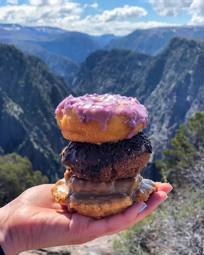
Bonus: Post Hike Donuts
It’s called Hiking for Donuts, so it would be a disservice if I did not include a post hike donut shop to visit after the hike. Fortunately, there is a fantastic donut shop in Colorado Springs about 20 minutes from the park called Amy’s Donuts. No exaggeration, they had over 40 different flavors/topping to choose from, which is a very tough decision to make. Flavors from Butterfinger to Fluffer Nutter to Nutella Crumb to all the standard donuts. And, the jelly donuts are filled fresh to order! Great donut shop find.

HIKING FOR DONUTS
Hi, I’m Mark. I live in Connecticut. I take new trips every chance I get. A good trip has a great hike, great food, and something fun to do. My goal is to search out new trips and share them to inspire others to try something new and exciting.
If you are looking for posts in a particular place, search City or State here.
SEE OTHER POSTS IN ARCHIVE
Archive
RECOMMENDED POSTS


RECENT POSTS


RECENT POSTS
See the latest on Instagram and follow @HIKINGFORDONUTS
Hiking in Iceland: Thórsmörk
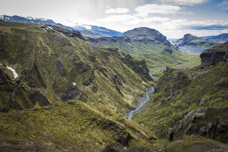
In 2010, a Volcano erupted in Southern Iceland. This eruption occurred near a popular hiking path from Skógar to Thórsmörk. Luckily, during my trip, the hiking route was opened. The terrain was difficult and cut the hike short but the views along the way were mesmerizing.
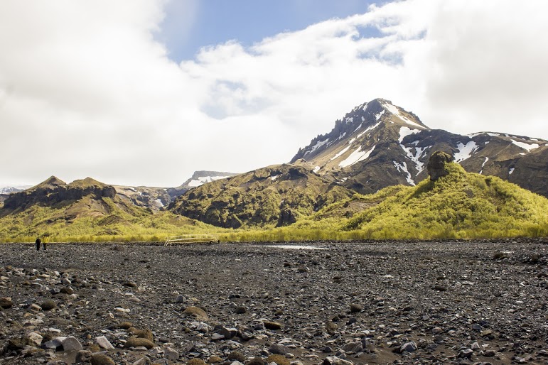
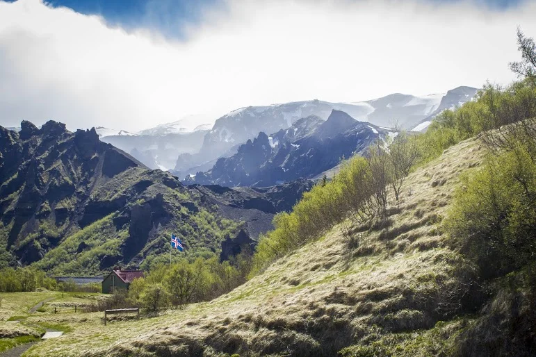
On my eight hour flight to Iceland, there was a lot of time to spare. The movie selection wasn’t great. And, then I saw the film, “The Secret Life of Walter Mitty.” Ben Stiller was in it and I figured it had to be decent. I started watching and realized, hey this is in Iceland. I turned to Corey and was like did you know this? And, he responded, yes I told you 10 times about this movie…..I’m not a good listener. As I watched, I would pause the movie every 20 minutes and say is this where we are going?!?!?! There was one scene where a volcano erupted and had Ben Stiller’s character running for cover. Pause again, I turn to Corey, are we going to see this? And he said, uh, we are hiking this. Oh snap. It’s about to go down. Eyjafjallajökull, you read that right, is a small ice cap located in Southern Iceland. In March, 2010, thousands of earthquakes were detected and caused an eruption in Fimmvörðuháls, the area of a popular hiking route from Skógar to Thórsmörk, which was then proceeded by a much more violent eruption at the top of the volcano, beneath the glacier. This second eruption caused massive floodwater to pour down the side of the volcano. Over 800 people were evacuated and Iceland’s Glacial Lagoons were destroyed. This even caused a stir with air traffic in Europe, which was paused for numerous days. Four years later, the devastation was still visible and lava was still smoking on the side of the volcano. As luck would have it, the hiking trails were opened and hikers can travel the route and take in these new views. And, that is what we planned to do if the weather permitted. We booked a night at the Volcano Huts in Thórsmörk, which was an awesome experience even if we didn’t attempt a hike. We had to take an hour long bus ride into Thórsmörk, crossing streams and passing glacier tongues.

The initial plan was to hike the entire trail close to 16 miles, see some lava. As we got closer, we realized there was no way we could safely make it to the Fimmvörðuháls pass. However, we like exploration and adventure. We decided to continue with our bold plan until we just couldn’t go on. Try to see as much as we can. You never know if you will be back.


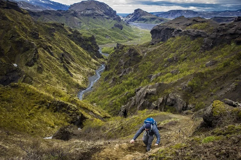
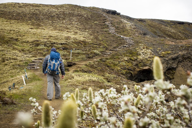
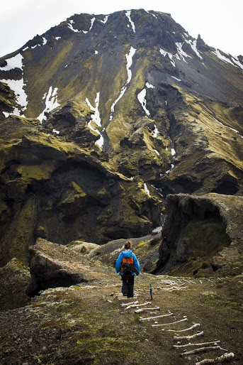
After speaking with the guide at the hut, we started our trek onto the beginning of the Fimmvörðuháls pass. The trail began with small brooks through a woodsy path. And, just like that we were exposed to a large field and a visual of glacial capped mountains. The next section of the hike was an enormous, rocky flood plain that we had to cross. There was a mobile bridge positioned at the end of the rocky terrain where the river was currently running through. We made our way across the bridge to the base of the snowy mountain on the opposite end of the valley where we started. We began our accent up the mountain and the terrain quickly transformed as snow began to appear. We crossed paths with our first hiker of the day heading the opposite direction. We made sure we were going in the right direction and were informed that the terrain was going to get dicey. And, there were currently blizzard conditions farther up the trail. We had packed for the worst, tents, extra clothing and food, so we continued on. Goals of lava steaming were still in sight.


As we made our way up the side of the mountain, patches of snow turned into thick layers of snow. And, this is where things got interesting. There weren’t any prior footprints to just step in as no one had dared to travel this far. We had to carefully, side step along the along the ridge line. Or else we were going sledding down the side of the mountain and……goodbye. We passed multiple sections of pure snow/ice drifts on this very steep mountain slope. Definitely one of the times I had some actual fear and wanting to maybe just turn around. But, persistence always prevails. Eventually we reached the top of the ridge trail and proceeded onto flat land covered in volcanic ash, mud, and rocks. We continued to trek across the this plain until we reached the cliff on the opposite side of the mountain.


At this point, the remainder of the trail looked too risky. As we would need to descend down between the mountains and ascend back up. After what we just did along the ridge line, we called it at this point. We regrouped and chomped on treats to refuel. Then, Corey noticed smoke on the side of the mountain and realized that it was cooling lava. We have attained our goal of seeking lava! The scene was remarkable. The experience was epic. This is what HikingforDonuts is all about. Push yourself, go beyond your comfort zone, and discover what’s out there. .....Then eat a donut ☺.


HIKING FOR DONUTS
A blog for the outdoors foodie enthusiast
Hi, I’m Mark. I live in Connecticut. I take new trips every chance I get. A good trip has a great hike, great food, and something fun to do. My goal is to search out new trips and share them to inspire others to try something new and exciting.
If you are looking for posts in a particular place, search by city or state here.
EXPLORE OTHER POSTS IN THE ARCHIVE
Archive
RECOMMENDED POSTS

MOST RECENT POSTS
See where I have been recently on Instagram. Follow @HIKINGFORDONUTS


