


Enders Falls, Granby, CT
Trail Description: Enders Falls is a quick out and back trail with multiple picturesque waterfalls.
Trail Info:
Where: Granby, CT Distance: 1 mile (30-45 min) Difficulty: Easy Trail Type: Out & Back Features: Views, Waterfalls, Water, Brook
How to get there:
Enders State Forest Granby, CT 06035
Click here for coordinates from GoogleMaps.
Hiking Tips
Bring bug spray for the applicable season.
There are a few trails off from the parking lot heading down to Enders Brook that will converge.
The Hike
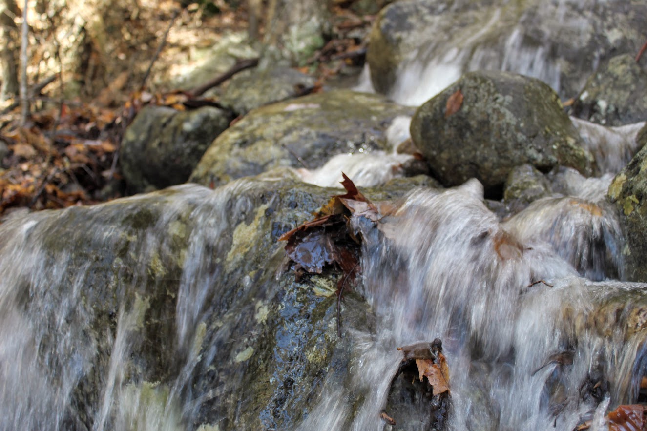
Waterfalls can be hit or miss for me. Sometimes they all just feel the same. Generally, my first inclination is to find a hike with cool summit views. However, things done changed, and that can’t always be the case. I have a toddler and many toddler nieces/nephews. I want to still get out in nature and show them all how awesome it is. And, waterfalls are a great hiking option for this. There are many in Connecticut that are accessible. I am behind on my CT waterfall game but that will likely change.
Enders Falls is an easy trail with 4-5 visible waterfalls that vary in size and look. The trail is very popular but we picked a great day and had the trail to ourselves. My wife had my daughter in a carrier and I had my nephew in my backpack carrier. And on we went to enjoy a day of nature.
From the parking lot, I definitely did not take the best course of action but we got back on track easily enough. The best start would be starting at the gravel in the far right corner by the porta potty.
There will be Purple markers (look pink to me) on the gravel trail and follow downstream to the staircase along the ravine. It seems this has been updated recently with steps of granite, fortified railings, and wooden fencing for safety purposes. It appears there were some accidents but it is very safe and well constructed. And, you can still get great views on some of the falls.

There is a good view of the 2nd waterfall and cliff area from the small viewing platform.

At the end of the staircase, there are stone steps that lead back to the gravel trail back to the parking lot for about a half mile.


HIKING FOR DONUTS
Hi, I’m Mark. I live in Connecticut. I take new trips every chance I get. A good trip has a great hike, great food, and something fun to do. My goal is to search out new trips and share them to inspire others to try something new and exciting.
If you are looking for posts in a particular place, search City or State here.
SEE OTHER POSTS IN ARCHIVE
Archive
RECOMMENDED POSTS


RECENT POSTS


See the latest on Instagram and follow @HIKINGFORDONUTS

People State Forest, Barkhamsted, CT
Located in Northwest Connecticut, the Jessie Gerard Trail is one of many exciting trails that wander through the 3000-acre Peoples State Forest. This fairly unknown hike is challenging with various terrain and magnificent views of Grand Vista Overlook and Chaugham Lookout. A great hike in the fall for amazing views.
Trail Description: The Jessie Gerard Trail is one of many exciting trails that wander through the 3000-acre Peoples State Forest. This fairly unknown hike is challenging with various terrain and magnificent views of Grand Vista Overlook and Chaugham Lookout.
Trail Info:
Where: People State Forest, Barkhamsted, CT Distance: 3.3 miles (2.5-3 hours) Difficulty: Moderate Trail Type: Loop Features: Waterfall, Valley, Views
How to get there:
Typing in Jessie Gerard Trail in your GPS will lead you to East River Road, Barkhamsted, CT. Once you get onto East River Road, drive a few miles and you will see a small parking lot on your left. The trail starts directly across from the lot.
Hiking Tips:
Take a DEEP People State Forest map at the kiosk in the beginning. This will be very useful.
Start with the Falls Cut Off Trail to your left (blue/red marked trail). Much easier to go up this section (than down). If it rained recently, the first 0.1m will be slippery up the rocks.
Pay attention to the markers changing colors

The Hike
The hike begins up the Falls Cut Off Trail (blue/red markers) on the left. The beginning of the trail is difficult and there is an immediate steep incline up past the falls. The beginning of the trail is difficult and there is an immediate steep incline up past the falls. There was a huge rain storm the day before so the waterfalls were roaring. An awesome visual after 10 minutes into the hike. Though, the rocks were really slippery. Once reaching the top of the falls, turn left on the double marked Blue and Blue/Yellow markers, which is the Jessie Gerard Trail. Continuing straight ahead on the Blue/Yellow,do not veer toward Warner Road. After another half mile, boom shakalaka we emerged into the Grand Vista outlook. Magnificent views with all the fall colors. We continued following the Blue/Yellow for another half mile to the Chaughum Lookout for more awesome views.
From here, stay on the Blue/Yellow Trail. We went between the 2 Veeder glacial erratics aka big boulder rocks. Shortly after, take a right onto Greenwoods Road. This is where the Jessie Gerard Trail ends. Then turn left on the Charles Pack Trail, also Blue/Yellow markings.
Another half mile later, turn onto Beaver Brook Road. This is where things got interesting. Following the road, the map says turn right onto the Blue/Orange, Agnes Bowen Trail, on your right after a half mile. When we came up to this, it was nothing but forest. No sign of a trail. We walked up and down and this was the spot. However, I don’t know where the trail would connect. We decided to keep walking up Beaver Brook Road and take a right up the road. Eventually, we caught up with the Blue/Orange trail where we would have come out to the road.
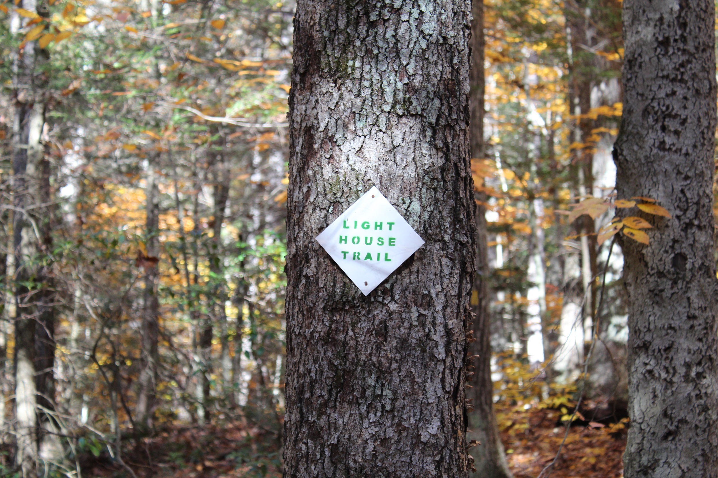
We jumped on the Blue/Orange to the left until we reached the Robert Ross Trail (Blue markers). Turn right here onto the Blue. The trail we will begin to ascend and descend. A tough part of the hike but way better than going down the other way. Keep your eye out on the colors on the trees. We got a little stumped here as the Blue/Yellow connects with the Blue. However, staying straight on the Blue the trail switchbacks downhill to the Lighthouse Trail (Yellow). Of course, another trail. Fortunately, this was the home stretch. We passed a few kiosks with educational info but we were ready for the post hike meal. This will take you back to the Blue/Red and right to the parking lot.


HIKING FOR DONUTS
A blog for the outdoors foodie enthusiast
Hi, I’m Mark. I live in Connecticut. I take new trips every chance I get. A good trip has a great hike, great food, and something fun to do. My goal is to search out new trips and share them to inspire others to try something new and exciting.
If you are looking for posts in a particular place, search by city or state here.
EXPLORE OTHER POSTS IN THE ARCHIVE
Archive
RECOMMENDED POSTS


MOST RECENT POSTS
SEE THE LATEST ON INSTAGRAM AND FOLLOW @HIKINGFORDONUTS


