


North-South Lake, North Point, The Catskills, NY
Trail Description: This great day hike in the Catskills at North-South Lake utilizing multiple trails offers stunning views such as Artists Rock, Sunset Rock, Newmans Ledge, and North Point. Also, some popular features such as Ashley Falls, Badmans Cave, and more.
Trail Info:
Where: Haines Falls, NY Distance: 7.0m (4-5 hours) Difficulty: Difficult Trail Type: Loop Features: Views, Mountains, Valley, Lake, Water, Cave, Catksills, Hudson Valley
How to get there:
93 North Lake Road, Haines Falls, NY 12436
https://goo.gl/maps/9rUFAjK3PieRJY7U9
Put the address above in your GPS. You will need to drive through the state park to find the trail. As you get closer, you will pass Scutt Road on the right, then go past the guardhouse. Turn right onto the first fork around the lakes heading south. Follow this road passing a big parking lot on the left until you reach another big parking lot at a dead end, past the pavilions. Park in this area and the trail will start in the back corner.
Hiking Tips
Not great phone service, so make sure to screenshot a map. Or my guide!
Lots of signage throughout trail, but keep an eye on the trail markers.
The Hike
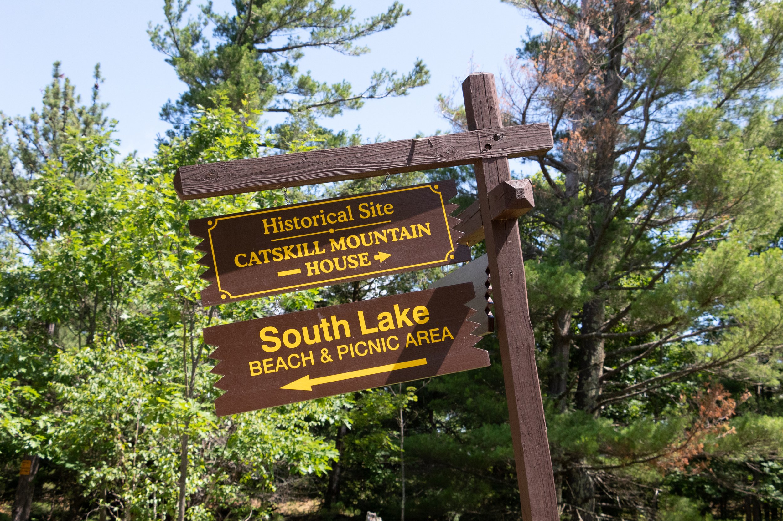
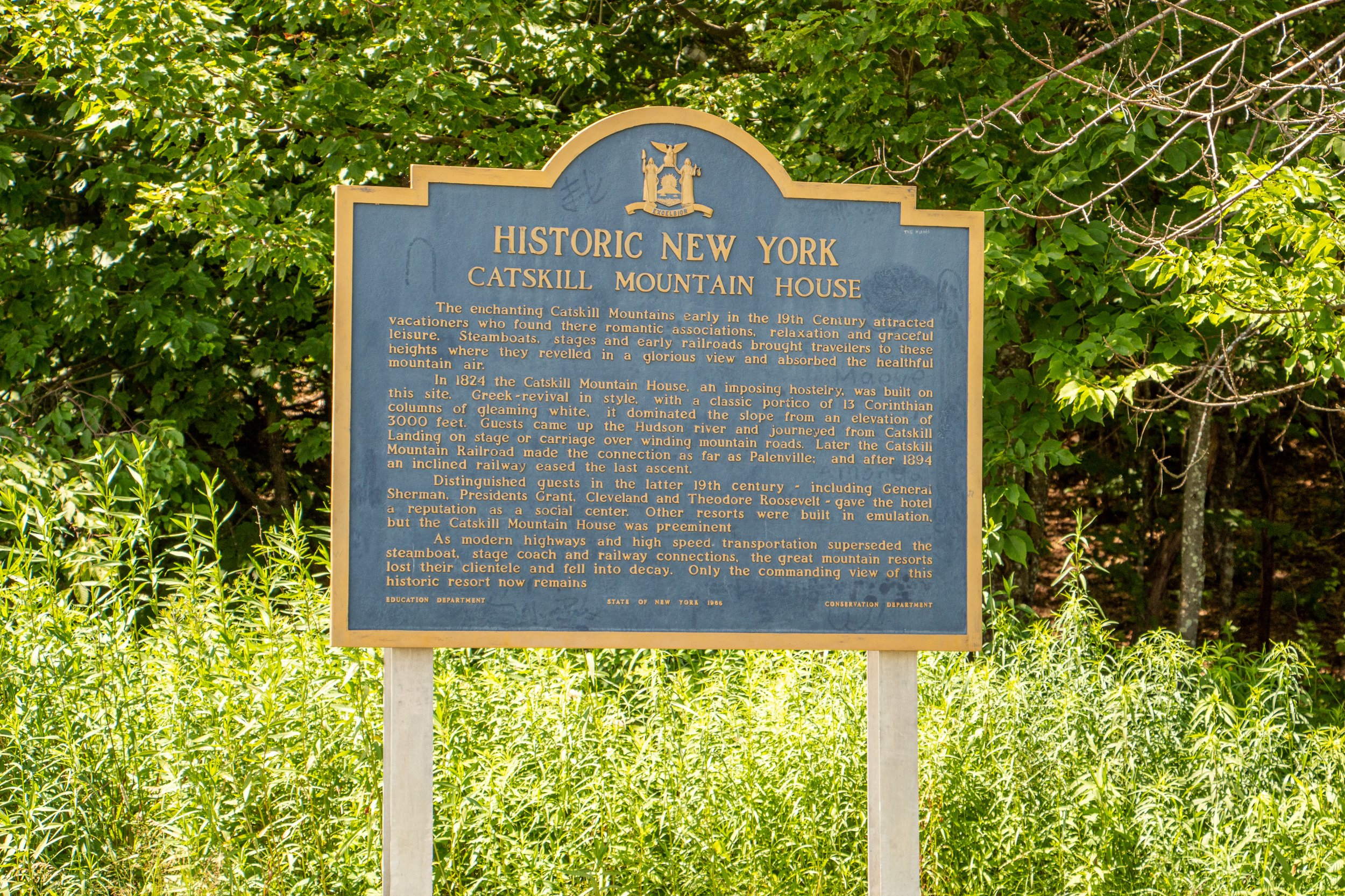
This is a long one folks. Make sure you have all the snacks and hydration necessary on this hike. Once you are ready to go, head to the back right corner of the parking lot for the start of the trail, away from the picnic pavilion and lake area. There will be a gate with a stop sign. Go around the gate and start your trek on the yellow trail toward the old Catskill Mountain House, the first of many sites and views on this hike.


There will be a junction with the blue trail. Continue to walk straight across the field at the area of the old Catskill Mountain House. Off the ledge of the field will be the first view of the hike overlooking the Hudson Valley.
Turn around and head back toward the junction across the field. Stick to the right and continue following the blue trail until you see the North Lake signage. Past the guardrail with a stop sign, cross another parking lot to re-enter the woods & head straight across to find the blue trail. I did not see a sign (could have missed it) but just keep an eye for the blue markers.
Pass the picnic tables and this will lead to walking along a chain link fence to the right. At the end of the fence, there is a view off a porch ledge. Keeping straight on blue, the next item to pass is a registration box.


From here, the hike will begin to have an incline. In about 10 minutes will be the first viewpoint, Artist’s Rock. The first of many views on this hike.
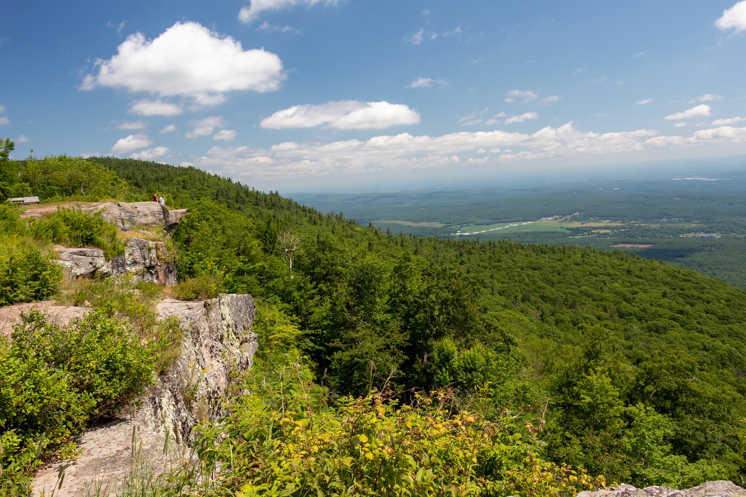
Continue on the blue trail as the trail gets steeper toward the next viewpoint, Sunset Rock. There will be a set of cliffs above on the right. Sunset Rock viewpoint sits above these cliffs. The trail will eventually get you there. There will be a sign to hop on the yellow trail for Sunset Rock in 0.2 miles.

Keep a lookout for the markers, then turn right onto the yellow trail. The views will just open up and another incredible view will be had. But this isn’t Sunset Rock quite yet. Keep along the yellow trail and in a few minutes there will be a big rock to the right. I was actually too enamored with the view, I did not take a picture of the rock! But it will be pretty obvious & there is a sign. This area will have the best views of the hike. There will be views of North-South Lake with the Catskills in the background. Pretty jaw dropping in my opinion.
From here, retrace your steps from the yellow trail back to the blue trail. Turn right at the blue/yellow junction to rejoin the blue trail. There will be signage for Newman’s Ledge, 0.2 miles away, and North Point, 1.6 miles away. The trail will get steeper but in minutes you will reach more awesome views off of Newman’s Ledge.
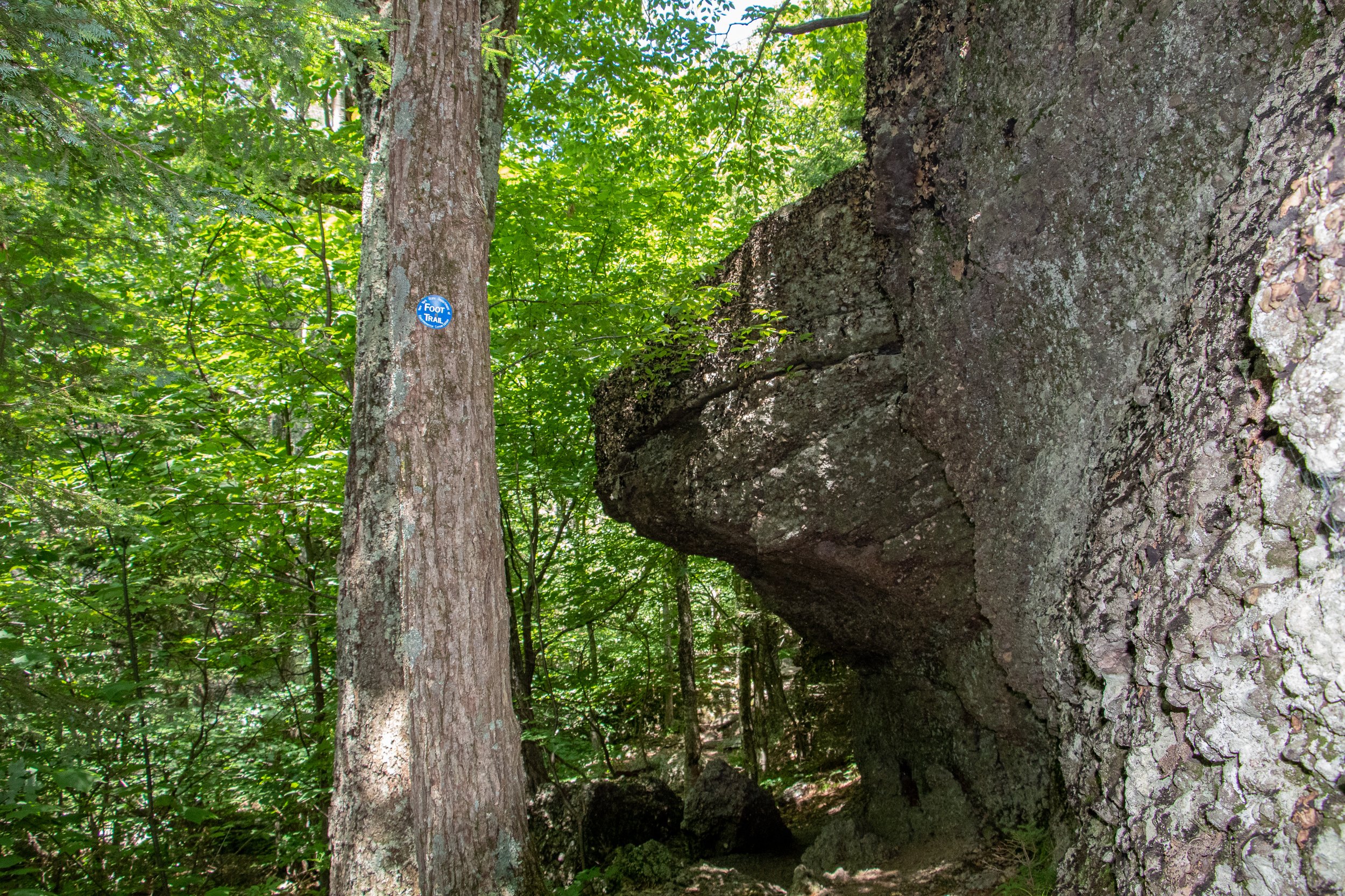
In about 0.6 miles the next point of interest is Badman's Cave following the blue trail.
Continue on the blue trail as it becomes steep then levels out in an open area before re-entering the woods. In 0.6 miles there will be a junction with the red marked Mary Glen’s Trail. The red trail will need to be used but for now continue on the blue trail toward North Point. There will be a sign showing only 0.3 miles to North Point. The ascend for the next 0.3 miles is one of toughest in the hike. There will be a sign for North Point. The views will be beautiful as the Catskills will be right in your sight.
After you soak in the last of the amazing views, begin to head back toward the junction with the red trail. Take a right to hop on the red trail. This will be a rocky, steady decline as you eventually reach the sign for the North Lake Campsite, which will be another 0.6 miles. This will lead around the lakes onto the paved roads of the campsite. Continue to follow the red trail as you cross a footbridge over a stream. There will be a sign for Ashley Falls off the yellow trail if you wanted to take a look, it was very short but no waterfalls on this hot day in the middle of the summer.


Continue on the red and take a left on the road by the campsites. Then it will be almost a mile until you get back to the parking lot. At least it is a flat surface to end! Whew, what a hike. Tough but so many views.


HIKING FOR DONUTS
Hi, I’m Mark. I live in Connecticut. I take new trips every chance I get. A good trip has a great hike, great food, and something fun to do. My goal is to search out new trips and share them to inspire others to try something new and exciting.
If you are looking for posts in a particular place, search City or State here.
SEE OTHER POSTS IN ARCHIVE
Archive
RECOMMENDED POSTS


RECENT POSTS


See the latest on Instagram and follow @HIKINGFORDONUTS

3 Easy Hikes in Mount Rainier National Park
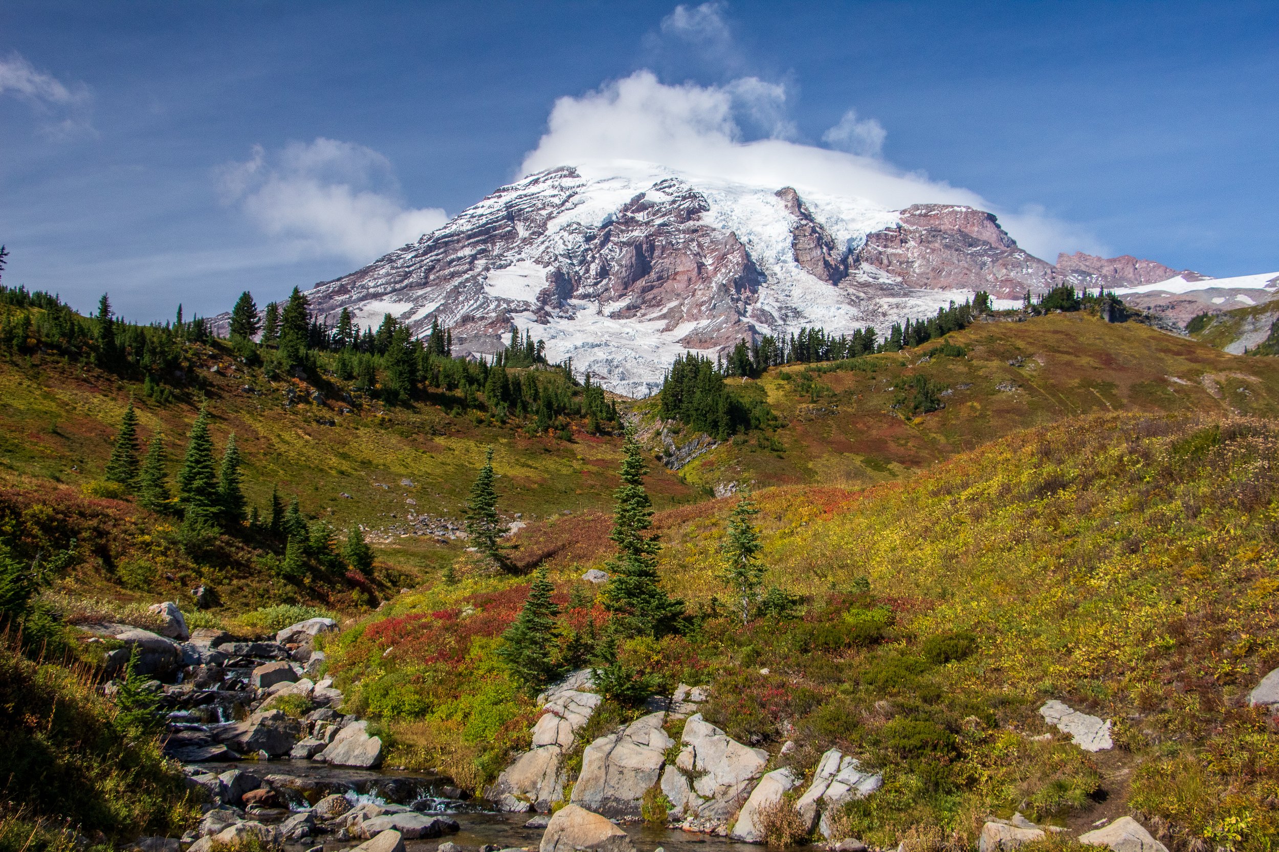
Mount Rainier National Park is one of the most beautiful parks in the United States. It’s got mountain views, rivers, waterfalls, old-growth forests, and meadows of wildflowers in the summer months. To say I was ecstatic to visit for the first time would be an understatement. However, this turned out to be a very interesting trip to plan and taught me some valuable lessons. One month before the trip, my wife tore her ACL hiking. I spent so many hours planning and like that, I had to shift plans. Credit to my amazing wife, she still wanted to go to Mount Rainier as planned and make the best out of it. Would I like this to be a full blown guide of the park? Of course. But stuff happens and guess what? Trips always work out. Our trip consisted of lots of driving through the park over 3 days and as many easy walks as possible as my wife was still able to put some pressure on her leg (she had surgery the week we came back). And, we still had an absolutely amazing time. The park is so big that we barely covered it. Sticking to the easier things to do in the park, I realized not every trip has to be insanely packed and hiking crazy to enjoy it. National Parks are for everyone. You don’t need to even hike too much if at all to enjoy it. I saw so many families and many elderly enjoying the park. For me, that is what it is about and I hope to be in my 70s-80s enjoying National Parks still. With that said, we were able to find some easier hikes with amazing views.
Some brief info on the park. Mount Rainier National Park is about 2-3 hours from Seattle based on the entrance you choose and a good 3 hours from Portland, OR. The best time to go to the park would likely be July to October. I would lean toward August or September but it really is a gamble. It was only clear and sunny one day when I visited and the other 2 days were cloudy, rainy, & foggy, and Mount Rainier was covered by the clouds. The park is huge and has 5 main sections: Longmire, Paradise, Ohanapecosh, Sunrise, and Carbon River/Mowich. Paradise is the most common and has the main park visitor center. Always make sure to check for closures and weather. For instance, one of the hikes I will be recommending, Grove of the Patriarchs, is currently closed for the rest of 2022.
As stated above, the Nationals Parks are really built for everyone these days. There is so much to see and you don’t need to do long or difficult hikes to get incredible views. If you want to get the best experience out of Mount Rainier National, here are 3 easy hikes that will be quick and fulfilling. Plus, a bonus viewpoint that may be one of the coolest areas to photograph in the park.
Myrtle Falls via Skyline Trail
Distance: 0.8 miles Trail Type: Out & Back
Getting to Myrtle Falls is a simple out & back from the Paradise parking area. Starting at the Skyline Trail on the paved portion heading east for about 0.4 miles and then crossing a small footbridge over Edith Creek Basin. Take a left off the path for the Myrtle Falls viewpoint. This is one of the popular waterfalls in the park standing at 60 feet with Mount Rainier standing tall in the background. This short hike is mostly all paved with little incline so this is for all ages and families looking to get amazing views.

Nisqually Vista Trail
Distance: 1.1 miles Trail Type: Loop
The Nisqually Vista Trail, located in the lower Paradise parking lot by the Henry Jackson Visitor Center, offers stunning mountain views and the trail is filled with wildflowers. There are several lookouts to view Mount Rainier, the Nisqually River, and potentially the lower reaches of the Nisqually Glacier. There is not much elevation to this trail and is one of the only paved trails in the park. This is another family friendly option and strollers are welcome starting from the upper Paradise parking lot, which has ramps to access trails.


Grove of the Patriarchs Trail
Distance: 1.1 miles Trail Type: Out & Back
The one word I felt walking along the Grove of the Patriarchs Trail was enchanted. Walking through the forest, the bright green color everywhere, all the moss, and of course the massive trees! This short hike is located on the Southeast section of Mount Rainier National Park. The trail meanders along the Ohanapecosh River that takes you to a suspension bridge to a small island destination. Here you will be surrounded by Douglas-firs, silver fir, hemlock, and Western red cedar trees. Some of the large trees can be 40-50 feet in diameter and over 300 feet tall. A very unique and breathtaking trail that is very flat for all ages to explore in the park.


Bonus: Reflection Lake
Another easy to access destination with amazing views is Reflection Lake. Located off Steven Canyon Rd, a few miles from the Paradise turnoff, just a short walk from the car is a perfect photography opportunity of Mount Rainier reflecting in the water. A great spot for sunset or sunrise. There are connecting hiking trails around the lake but all is needed is a view off the road. Definitely a bucket list stop in Mount Rainier National Park. My personal favorite of my trip even with the cloudy weather.

HIKING FOR DONUTS
Hi, I’m Mark. I live in Connecticut. I take new trips every chance I get. A good trip has a great hike, great food, and something fun to do. My goal is to search out new trips and share them to inspire others to try something new and exciting.
If you are looking for posts in a particular place, search City or State here.
SEE OTHER POSTS IN ARCHIVE
Archive
RECOMMENDED POSTS


RECENT POSTS
See the latest on Instagram and follow @HIKINGFORDONUTS

Ninham Mountain Fire Tower Hike
Ninham Mountain Fire Tower Trail Guide (Carmel Hamlet, NY)
Hiking Ninham Mountain Fire Tower in NY. Another great Hudson Valley, NY hike. Easy hike, beautiful views.
Trail Description: Ninham Mountain Fire Tower is a short hike that provides an amazing 360 view of rolling hills, lakes, and reservoirs from the top. A glimpse of the Catskills can be visible with clear skies.
Trail Info:
Where: Ninham Mountain Fire Tower, Kent, NY Distance: 1.3 miles (1 hour) Difficulty: Easy Trail Type: Out and Back Features: Fire Tower, Lake, Views, Rolling Hills, Reservoir
How to get there:
As always, do your research on hikes. I read that finding the trail parking was an issue for some hikers. Luckily, I saw that and made sure we had the right directions. We found it pretty easy. It is in the middle of nowhere. The GPS I would enter is Mount Nimham Ct, Carmel Hamlet, NY 10512. This took us on the Taconic State Parkway. Once we were on Gypsy Trail Road, we made another right onto Mt. Nimham Ct. You will see a sign for Ninham Mountain Multiple Use Area. Follow this all the way down until you see the parking lot.
Hiking Tips
Finding the parking lot can be tricky.
The old stone chambers are directly across the parking area. This may be covered by bushes.
The Hike
Traveling through the Hudson Valley area once again, I was in search of a shorter hike. Always need to walk off the beer and donuts from weekend activities. I have a huge list of hikes to do in the area, but my girlfriend and I had some time constraints driving back to CT. Thankful for other hiking bloggers, I came across Ninham Mountain Fire Tower in Kent, NY. The hike was more of a walk with an incline, but the views were fantastic from the fire tower.
Wonder Lake.
Look for these signs at the entrance.
Where the Trail head starts. Parking area is to your left.
The trail head will start behind the gate. Before you even start, don’t miss the old stone chambers directly across the parking lot behind you like we did. We didn’t notice until we were ready to leave. The only reason we had these on our mind was that we read this area was full of paranormal activity. I took my pictures and walked away. I’m no ghost hunter.
Old stone chamber.
Now, onto the hike. Just continue up the gravel road. The trail is uphill but it’s not bad at all. Nothing too difficult but still a good workout. This seemed to be a popular trail for mountain bikers as well. It took us about 15-20 minutes to reach the fire tower.
pretty easy gravel road.
all the way up.
Ninham Mountain FIre Tower
The 360-degree view at the top of the tower was amazing. It was beautiful weather and a clearly visible day. You will see rolling hills, lakes, and reservoirs. The Catskills are also visible in the distance. After you have soaked it all in, you will come back down and walk the same path to your car. Pretty quick and easy. There are some trails you will see off the path but I can’t speak to those.
clear skies and rolling hills.
the money view.

Rolling hills a little closer.
Little overcast on this side of the tower.
Round trip and going up & down the fire tower, this is a total of 1.3 miles. This took us less than a hour. I am glad I came across this spot in my research. If you want the most bang for your buck, this jaunt checks all the boxes including a spectacular view.
HIking for donuts models.

HIKING FOR DONUTS
A blog for the outdoors foodie enthusiast
Hi, I’m Mark. I live in Connecticut. I take new trips every chance I get. A good trip has a great hike, great food, and something fun to do. My goal is to search out new trips and share them to inspire others to try something new and exciting.
If you are looking for posts in a particular place, search by city or state here.
EXPLORE OTHER POSTS IN THE ARCHIVE
Archive
RECOMMENDED POSTS


MOST RECENT POSTS
See where I have been recently on Instagram. Follow @HIKINGFORDONUTS


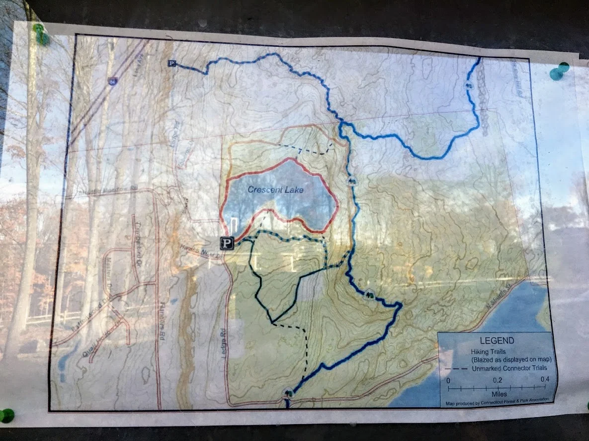
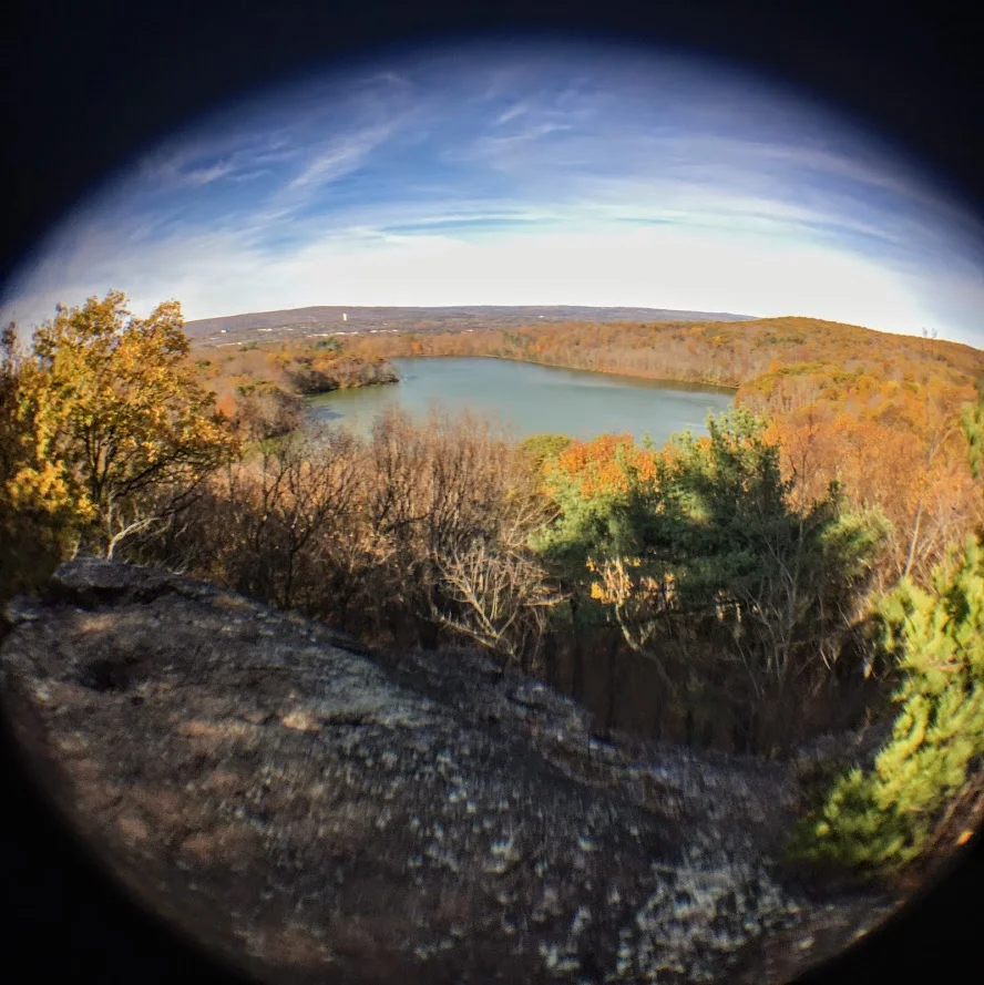
Sunset Rock State Park, Crescent Lake, Southington, CT
Check out the Crescent Lake trail in Southington, CT. This was a confusing trail but well worth the views. Enjoy!
Trail Description: Sunset Rock State Park offers a scenic hike around Crescent Lake that connects to the Metacomet Trail.
Trail Info:
Where: Southington, CT Distance 3.2 miles (2-2.5 hrs) Difficulty: Easy to Moderate Trail Type: Loop Features: Views, Lake, Water
How to get there:
Address to GPS: 357 Shuttle Meadow Rd, Plainville, CT 06062. Parking lot is easy to find.
Hiking Tips
Three trails to choose from. The Blue to Orange trail takes you above the lake and is rockier and steeper. Much better views.
Be mindful if you lose the trail markings or end up on a different trail. There is a lack of trail markings. And, some confusing areas where trail markers change colors.
The Hike
On this brisk fall weekend, we decided to hike the Crescent Lake Trail in Southington, CT. This is one of those trails that there isn’t the best information online and it is poorly marked. I will do my best explaining but my advice is always have the map handy and make sure someone is good at directions!
The parking lot is easy to get to, it is off Shuttle Meadow Road. Once you park you will see the lake right in front of you and potentially some people fishing. There are 3 trails. The Red trail is the lower level trail which is mostly flat. This is to your far left from the lot. This is roughly 2m. The blue -orange trails takes you the upper levels to get good views above the lake and this is rockier and steeper. This trail is to your right from the lot. This is about 3.2m and this connects to the Red at the end once you descend down. There is also a green trail, but not sure where that takes you. It appeared to be just a woodsy hike.
We got lost a few times but Nichole is really good with reading trail maps. The issue is lack of markings/incorrect markings. And, the Metacomet Trail connects so you have to be very careful when the colors change. We took the upper trail followed blue-orange markers until we saw just orange then to red. There we were some tough sections where you could choose 3 directions but there are big orange arrows on trees along the way so be mindful of those. There is also an intersection where you see trail arrows for the Metacomet at the top, keep going toward the blue orange and you will pass a camp fire pit. Minus the confusion, it was a cool hike and the view was awesome from the top. I could of took pictures for an hour….luckily, Nichole stopped me. The upper trail I would suggest hiking boots. It was a moderate hike for beginner to intermediate. Some of the inclines got our hearts beating and needing some water. I think this would be a good spot to snowshoe. I hope to keep the fall hikes going. Another local spot in the books, glad we decided to try it even though the reviews were suspect.
Review:
Cresent Lake Trail, 3.2m (Southington, CT): 4 out of 5


HIKING FOR DONUTS
A blog for the outdoors foodie enthusiast
Hi, I’m Mark. I live in Connecticut. I take new trips every chance I get. A good trip has a great hike, great food, and something fun to do. My goal is to search out new trips and share them to inspire others to try something new and exciting.
If you are looking for posts in a particular place, search by city or state here.
EXPLORE OTHER POSTS IN THE ARCHIVE
Archive
RECOMMENDED POSTS


MOST RECENT POSTS
See where I have been recently on Instagram. Follow @HIKINGFORDONUTS