


Enders Falls, Granby, CT
Trail Description: Enders Falls is a quick out and back trail with multiple picturesque waterfalls.
Trail Info:
Where: Granby, CT Distance: 1 mile (30-45 min) Difficulty: Easy Trail Type: Out & Back Features: Views, Waterfalls, Water, Brook
How to get there:
Enders State Forest Granby, CT 06035
Click here for coordinates from GoogleMaps.
Hiking Tips
Bring bug spray for the applicable season.
There are a few trails off from the parking lot heading down to Enders Brook that will converge.
The Hike
Waterfalls can be hit or miss for me. Sometimes they all just feel the same. Generally, my first inclination is to find a hike with cool summit views. However, things done changed, and that can’t always be the case. I have a toddler and many toddler nieces/nephews. I want to still get out in nature and show them all how awesome it is. And, waterfalls are a great hiking option for this. There are many in Connecticut that are accessible. I am behind on my CT waterfall game but that will likely change.
Enders Falls is an easy trail with 4-5 visible waterfalls that vary in size and look. The trail is very popular but we picked a great day and had the trail to ourselves. My wife had my daughter in a carrier and I had my nephew in my backpack carrier. And on we went to enjoy a day of nature.
From the parking lot, I definitely did not take the best course of action but we got back on track easily enough. The best start would be starting at the gravel in the far right corner by the porta potty.
There will be Purple markers (look pink to me) on the gravel trail and follow downstream to the staircase along the ravine. It seems this has been updated recently with steps of granite, fortified railings, and wooden fencing for safety purposes. It appears there were some accidents but it is very safe and well constructed. And, you can still get great views on some of the falls.

There is a good view of the 2nd waterfall and cliff area from the small viewing platform.

At the end of the staircase, there are stone steps that lead back to the gravel trail back to the parking lot for about a half mile.


HIKING FOR DONUTS
Hi, I’m Mark. I live in Connecticut. I take new trips every chance I get. A good trip has a great hike, great food, and something fun to do. My goal is to search out new trips and share them to inspire others to try something new and exciting.
If you are looking for posts in a particular place, search City or State here.
SEE OTHER POSTS IN ARCHIVE
Archive
RECOMMENDED POSTS


RECENT POSTS


See the latest on Instagram and follow @HIKINGFORDONUTS

Hiking Mount Agamenticus, York, Maine
Trail Description: The Mount Agamenticus Conservation Region is located in Southern Maine. The Mount Agamenticus Loop is a popular trail that provides 360 degree views at the summit of the surrounding mountains in the distance.
Trail Info:
Where: York, ME Distance: 1.8m (1 hour) Difficulty: Easy toModerate Trail Type: Loop Features: Views, Mountains, Valley
How to get there:
Typing the location “Mount Agamenticus Trailhead” into Google Maps will take you to the parking lot. You can’t miss it. There is a lot of parking. It’s $2/hr to park and there is a barcode to scan for the app to use to pay. It was easy peasy in my opinion. And, worth the money based on how well they keep up with everything.
Coordinates: 43.21720438450835, -70.69198787482621
Link to google maps location here.
Hiking Tips
I suggest caution if it rained days prior. The trails in the forest are mostly roots and rock. Dry it’s no biggie but wet I don’t think it would be as enjoyable.
Download a copy of the trail map here.
There are multiple trail options. This guide is for the loop via Blueberry Bluff, Witch Hazel, and Ring Trail. The Big A trail has separate parking and is a 1 mile loop that’s mostly gravel & an easier option (stroller and wheelchair friendly).
The trail and parking lots are well maintained and great facilities. Nicest outhouse bathrooms I ever been in!

The Hike
Once parked at the Mountain Road parking lot, the beginning of the trail head is visible with markers at end of the parking lot.

There will be trail signs promptly upon starting the hike at a fork. Stay right and hop on the Ring Trail, which is the white marked trail.

As stated prior, the trail is very well marked. However, the trail is mostly rocks and roots. I saw some reviews mentioning that it was muddy and unpleasant after a rainstorm. And, I totally understand what they meant. The rocks and roots could be slippery. For us, it was dry and there were no issues.

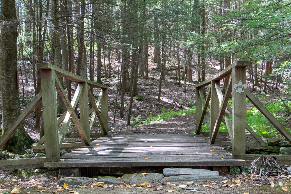
There isn’t much of an elevation gain, only about 340 feet. But there is a small incline as you make your way to the top. Hiking along the Ring Trail, at almost 0.7m, there will be a small foot bridge with a path to the left at the end. This is the Witch Hazel trail. I did not see signs but based on the trail map, this was the way to go.

The Witch Hazel trail is brief. Only a few minutes to reach the Big A Trail. There will also be a small foot bridge.

And following the Big A trail at the top is where the first lookout platform is to take in all the views.

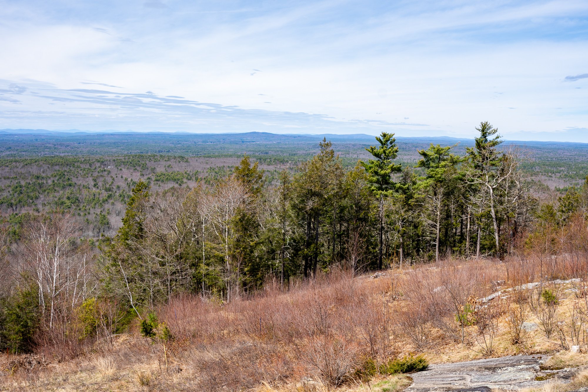
There is another lookout platform with stairs where you can see even higher out into the valley. There is also a fire tower, but it is fenced out and cannot be climbed.


Follow the Big A Trail out until it connects to the Blueberry Bluff, which is marked red. There is also an additional viewpoint here before the Blueberry Bluff.

Continue down the Blueberry Bluff back to the Ring Trail. Take a left at the sign back to the parking lot. You will cross the road at the end to get back to your car.

Southern Maine is tracking to be one of our favorite areas to visit and this was a great first hike in the area. Good hike to get the heart going and see some cool views. The platforms are a cool feature for viewing on the summit. And, the trails and parking lots are so well maintained. I cannot speak highly enough on that. I was not able to find a great guide with details for this hike so I am hopeful this will be helpful for others. It’s also good to see directions/steps before you go to get comfortability. Not a hard hike to follow but I understand where folks can get tripped up. I still do it many times. Luckily, my wife is always the voice of direction.
POST HIKE ACTIVITIES: The fun doesn’t have to stop here. Lots to do in the area. We stopped by the 90s themed brewery, Odd by Nature Brewing, for some post hike beers and nosh, which is about 8 minutes from the trailhead. And, the Nubble Lighthouse is roughly 15 minutes or so away. Definitely a trip to view. Cape Neddick is really cool. Many restaurants in the area as well. No matter what you decide to do, there is a lot to plan for a great weekend or day trip.

HIKING FOR DONUTS
Hi, I’m Mark. I live in Connecticut. I take new trips every chance I get. A good trip has a great hike, great food, and something fun to do. My goal is to search out new trips and share them to inspire others to try something new and exciting.
If you are looking for posts in a particular place, search City or State here.
SEE OTHER POSTS IN ARCHIVE
Archive
RECOMMENDED POSTS


RECENT POSTS
See the latest on Instagram and follow @HIKINGFORDONUTS

Hidden Valley Preserve, Washington Depot, CT
Trail Description: The Bee Brook Loop is one of many trails in the Hidden Valley Preserve. This hike is an easy stroll along the Shepaug River. The Thoreau Bridge is the biggest attraction.
Trail Info:
Where: Washington Depot, CT Distance: 2.2m (1-1.5 hours) Difficulty: Easy Trail Type: Loop Features: Bridge, River, Water
How to get there:
198 Bee Brook Rd, Washington Depot, CT 06794
Parking lot can fit about 10-12 vehicles.
https://goo.gl/maps/Y1RQqqrmAjda6dcUA
Hiking Tips
Taking the fork to the right will bring you to the Thoreau Bridge within minutes.
There are other parking areas for different trails.
Trail map: Click Here!
The Hike
Apparently, the Washington, CT area is the mecca of public preserves in Connecticut. By mecca, I mean there’s three in a short distance of each other, which is pretty cool for nature buffs and hikers. Hidden Valley Preserve is one of three public preserves in the area owned by Steep Rock Association, along with Steep Rock Preserve and Macricostas Preserve. Hidden Valley Preserve offers 17 miles of trails consisting of various terrains and points of interest. The yellow blazed trail, known as Van Sinderen Loop Trail, will lead to the Quartz Mine and the “Lookout”, providing scenic views of the valley to the west. The Pinnacle Trail, blue blazed, also offers scenic valley views. The white blazed trail is the Bee Brook Loop, which is the quickest way to get to the Thoreau Bridge. That is the trail in this guide.
From the parking lot, there is a small footbridge that passes a small creek. This will lead to the start of the trail. There is a fork to choose your direction and we chose to go right following the White Trail for the Bee Brook Loop. Within minutes we arrived at the main attraction of the hike (for most), the Thoreau Bridge. This is a 134 foot suspension bridge hanging above the Shepaug River named in tribute to Henry David Thoreau. He was a philosopher, nature enthusiast, and advocate of hiking in the 1860s. Typically, this doesn’t do much for me nor do I get into details of history but the bridge contained many of his quotes along the railings that spoke to me.
The bridge was definitely the most busy part of this hike. It is a cool point of interest and really easy to get to. Now, I understand why it’s such a big instagram photo spot. From here, you can cross the bridge and continue onto another trail but we stayed on the White Trail hiking along the river.
Eventually, there is another wooden bridge that crosses the river on the right. This will connect you to the Yellow Trail if you want to jump on that. We just continued on the white blazed rail to finish the loop where we started. The hike was a pretty easy loop with some scenic river views. That was all I was looking for that day. Just a bit of time with nature.
HIKING FOR DONUTS
Hi, I’m Mark. I live in Connecticut. I take new trips every chance I get. A good trip has a great hike, great food, and something fun to do. My goal is to search out new trips and share them to inspire others to try something new and exciting.
If you are looking for posts in a particular place, search City or State here.
SEE OTHER POSTS IN ARCHIVE
Archive
RECOMMENDED POSTS


RECENT POSTS
See the latest on Instagram and follow @HIKINGFORDONUTS


Jones Mountain Preserve, New Hartford, CT
Trail Description: The Vista Trail is a red-blazed loop that circles the Jones Mountain Preserve. Most of the trail is an old carriage road that leads to summit views overlooking New Hartford and the Farming River to the north.
Trail Info:
Where: New Hartford, CT Distance: 2.5m (1.5 hours) Difficulty: Easy Trail Type: Loop Features: Views, Mountains, Valley
How to get there:
161 Steele Rd, New Hartford, CT 06057
You will see the parking lot located on the right coming from Route US-44W.
Hiking Tips
For trail map, click HERE.
Stay on the trails. Lots of hunting areas surrounding.
The Hike
Once entering the nature preserve from the parking lot, there is a footbridge crossing. There will be a fork for the start of the red blazed trail. This is the Vista Trail that loops around the preserve. Going right will lead you to the summit view. After about 0.3m there is a sign with an arrow toward the peak to follow.
This part of the hike is the most difficult. There is a gradual incline with an elevation gain of 367 feet as you make your way toward the carriage road. This will last for 15 minutes or so. Reaching the carriage road will occur at about 0.5m and it is fairly easy from here. At 0.9m there is another footbridge crossing.

This will bring you to the summit of Jones Mountain at 1.5m. The lookout is a splendid view of the Farmington Valley West to New Hartford.
Continue on the red loop for the rest of the trail. Due to storms, there is a road closure at the time of our hike. This forces you to hop onto the white trail inside the preserve. The white will lead back to the red and right to the parking lot.
Based on what I saw online, there are some monuments and mill ruins along other trails in the preserve if that interests anyone reading this. We chose to just tackle the summit view.
I am enjoying finding new hiking trails in Connecticut. This trail is fairly easy, has a good view, and will get your heart pumping a little bit. Any one looking to get into hiking or just need a break from a strenuous trail, I would suggest this. Fall is officially here as I write this post. This would be a good fall hike as well once the leaves change. Get hiking!
HIKING FOR DONUTS
Hi, I’m Mark. I live in Connecticut. I take new trips every change I get. A good trip has a great hike, great food, and something fun to do. My goal is to search out new trips and share them to inspire others to try something new and exciting.
If you are looking for posts in a particular place, search City or State here.
SEE OTHER POSTS IN ARCHIVE
Archive
RECOMMENDED POSTS


RECENT POSTS
See the latest on Instagram and follow @HIKINGFORDONUTS

Old Furnace State Park, Killingly, CT
Old Furnace State Park is located in Killingly near Rhode Island. This is a great park for hiking, biking, and fishing. Exploring new areas is always fun, even if you get lost on the trails. Check out the blog to make sure you stay on the trails!


Scrolling through the list of the 2018 Sky’s Limit Hiking Challenge in Connecticut, I wanted to explore unknown parts of the state that would be new to me. I haven’t spent much time in the Windham County area, neighboring Rhode Island. I really had no idea where I was going and there was not too much info on the park online. But, I convinced my girlfriend to drive over an hour with a promise of beers and off we went.
Old Furnace State Park is located in Killingly, CT. You will find the park entrance off Route 6 via Route 395. Ross Pond State Park is fairly close so my GPS took me there instead. If yours does the same, just keep going past that until you can take a left onto South Frontage Road and the park will be there on your left. The blue-blazed trail of this park runs about 3 miles. This particular hiking challenge calls for 2 miles round trip until you reach the overlook from the cliffs at 200 feet over Half Hill Pond. With this view you get a great look of valley stretching into Rhode Island.

We finally found the parking lot and noticed there was mountain biking event going on. Apparently, this is a big mountain biking trail. I didn’t expect to see anyone. The hiking trail starts at the parking lot. I used the trail located at ct.gov here . The path instantaneously takes you into the woods.

As we began, we crossed a small brook that led us to crossing a small footbridge.


The trail was fairly wide open until we reached an unmarked section ducking through a brush of bushes. We found ourselves questioning our direction. Eventually, a blue marker did appear.


From here the ascent started to get steep. About a mile into the hike, we saw the path break into two. Unfortunately, we kept going straight and that was not correct and saw some brown marked trails.


Thus, we circled back and took the path to the left which was the ridge along the pond. And, finally we found ourselves at the cliffs overlooking Half Hill Pond. The pond was completely filled with water lilies.


We stopped here because the trail was pretty buggy and I didn’t think the rest of the trail would offer much. But if you want to continue, this will lead you down to the parking lot and boat ramp at Ross Pond to Squaw Rock Road where you turn around and come back. If you are not from the area, the directions to the park could be difficult and the trail itself has areas that should be marked better. The hike itself was not hard. I would rate it easy. I would bring bug spray and pay very close attention for the blue markers. Looks like a good area to fish and maybe kayak as well. I’m sure this is a nice spot for locals but one time is probably enough for me.
The Review
Old Furnace State Park, Blue Trail, Killingly, CT (~2m): 2.5 out of 5.

HIKING FOR DONUTS
A blog for the outdoors foodie enthusiast
Hi, I’m Mark. I live in Connecticut. I take new trips every chance I get. A good trip has a great hike, great food, and something fun to do. My goal is to search out new trips and share them to inspire others to try something new and exciting.
If you are looking for posts in a particular place, search by city or state here.
EXPLORE OTHER POSTS IN THE ARCHIVE
Archive
RECOMMENDED POSTS

MOST RECENT POSTS
See where I have been recently on Instagram. Follow @HIKINGFORDONUTS
River Highlands State Park, Cromwell, CT
This is the first hiking trail review on the Connecticut hiking challenge trails. Check out the blog to learn more about the challenge!
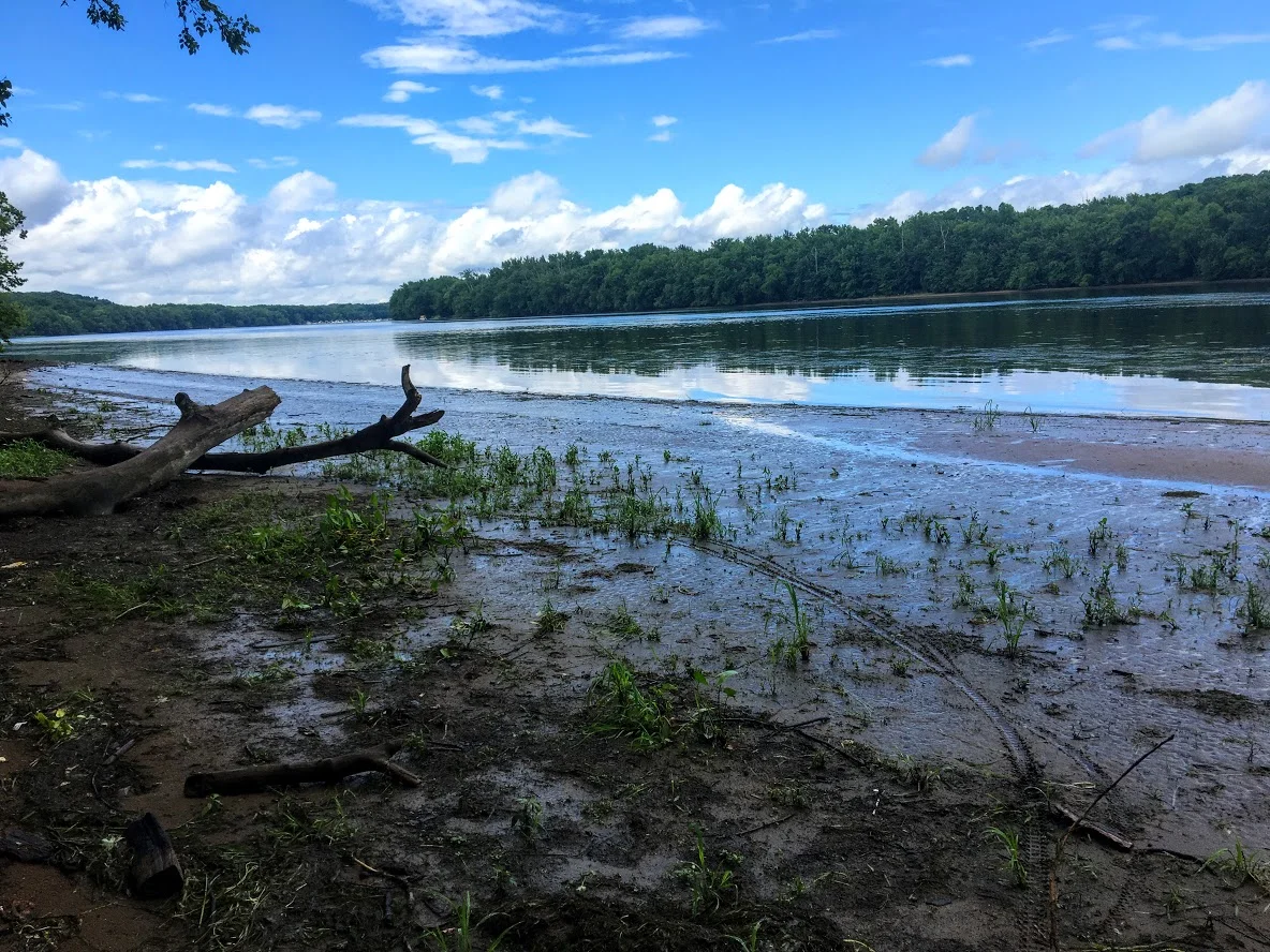
Trail Description: A view 150 feet up of the Connecticut River can be seen from the White Blazed Trail in the River Highlands State Park. In addition, there is water front with picnic tables to enjoy.
Trail Info:
Where: River Highlands State Park, Cromwell, CT Distance 1.5 miles (1 hr) Difficulty: Easy Trail Type: Loop Features: Views, River, Water
How to get there:
Directions in detail can be found here,https://www.ct.gov/deep/cwp/view.asp?a=2716&q=434748&deepNav_GID=1650.
River Highlands State Park, Field Rd, Cromwell, CT 06416
Hiking Tips
Good beginner hike or weekday hike after work.
Super buggy area. Bring bug spray.

The Hike
Finding good hikes in Connecticut is becoming less a challenge. And, that is a good thing. Most people just dismiss how much is truly out there. Recently my friend told me there is a hiking challenge in CT. I can’t believe I haven’t come across this. Of course, I googled and found Sky’s the Limit Hiking Challenge by the CT Department of Electric & Environment Protection (DEEP). They list 14 lesser known trails to encourage more hiking in CT state parks. There are rules and info here. You can win some prizes too. I think it is a great idea. I haven’t heard of most of the trails. I smell some new blog material. I am definitely on-board and will be joining in on the fun.
With that said, here in my very first hike of the Sky’s the Limit challenge. A rare weekday hike but if it is 90 degrees in May in CT, you get outside. Nichole and I went to River Highlands State Park in Cromwell, CT. This was an easier and quick hike. The hike offers views of the Connecticut River from 150 feet above the water. I would use this link for the trail maps. Directions can be found on the CT DEEP link above.


The park consists of multiple color trails. You can go multiple different directions. The biggest loop will take you about 2 miles but you can connect to many different trails and adventure as much as you want. The trails are very well marked and the terrain is pretty level. Maybe one or 2 short, steep sections. We chose the white trail from the parking lot. This takes you directly to the high bluffs overlooking the Connecticut River.

More river views.
From there we took the yellow trail down to the camping site. Typically, you can go to the bottom and walk out to get more views of the river. However, due to all the rain we had recently, the water was really high. Trees and picnic tables were covered. It is probably best to do this hike in the summer. Luckily, I did this a few years ago when the water was low.


After trying to snap some good IG pics, we continued to follow the yellow trail out to the parking lot. There are quite a bit of small bridges to cross over. And, this particular area is swampy and gets very buggy. Tons of mosquitoes. I suggest Deep Woods spray for this hike.


We did do some adventuring off the trails mentioned but it shouldn’t be more than 1.5 miles if you use the white to yellow marked trails. Barely took us an hour. This is a very good beginner hike. You don’t need boots but it is a wetlands area so it can be very muddy. It’s a good, quick hike for those locally.

HIKING FOR DONUTS
A blog for the outdoors foodie enthusiast
Hi, I’m Mark. I live in Connecticut. I take new trips every chance I get. A good trip has a great hike, great food, and something fun to do. My goal is to search out new trips and share them to inspire others to try something new and exciting.
If you are looking for posts in a particular place, search by city or state here.
EXPLORE OTHER POSTS IN THE ARCHIVE
Archive
RECOMMENDED POSTS
MOST RECENT POSTS
See where I have been recently on Instagram. Follow @HIKINGFORDONUTS

Mine Hill Preserve Trail, Roxbury, CT
More fun fall hikes in CT! The fall colors are really showing now. I decided to hike a new trail this time. I chose Mine Hill Reserve Trail in Roxbury, CT. The trail was unique and offered cool historic features. Check it out for great leaf peeper pics.
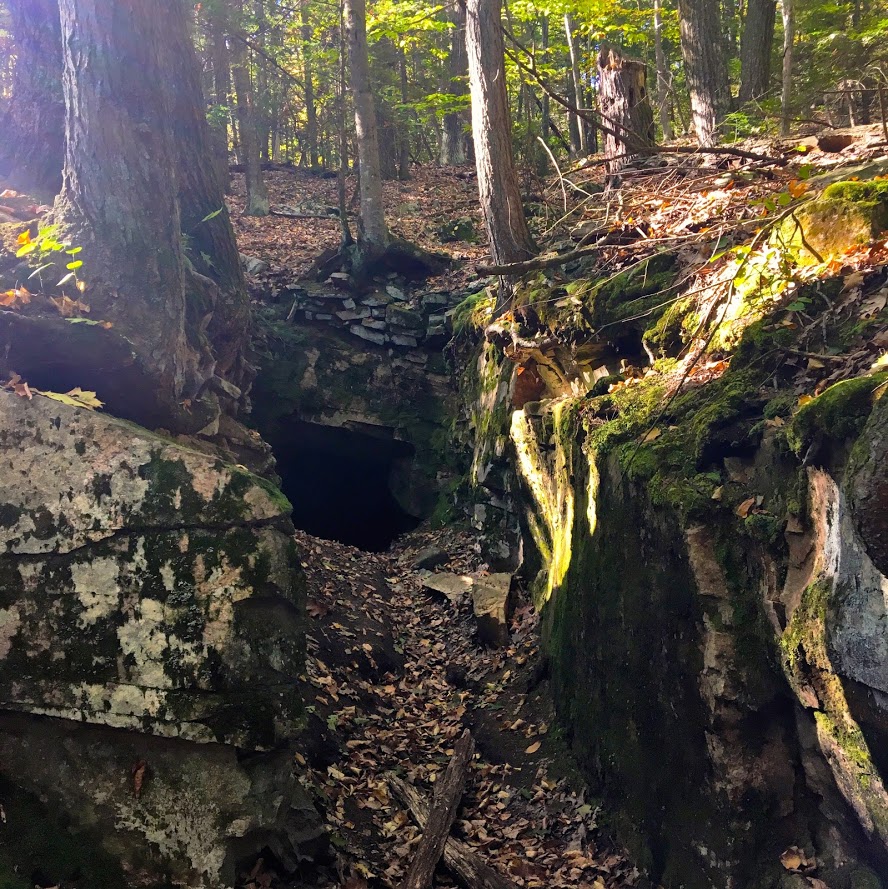
Trail Description: The Mine Hill Preserve trail is part of the Roxbury Land Trust as a national historical landmark. Venturing on this trail will take you through scenic woodlands, rocky terrain, mine tunnels, bat caves, and old furnace structures from the 19th century.
Trail Info:
Where: Roxbury, CT
Distance 3.6 miles (2 hrs)
Difficulty: Easy to Moderate
Trail Type: Loop
Features: Water, Bat Caves, Quarry, Bridge, Mine Tunnels, Old Furnaces
How to get there:
6 Mine Hill Road, Roxbury, CT 06783
The GPS lost signal as I got on Mine Hill Road, but just follow the signs on the gravel road to the parking lot.
Hiking Tips
Download a map of the trail, http://www.roxburylandtrust.org/MapMineHill.pdf.
Veer left to start with the more difficult section toward the Donkey Trail. The latter part of the trail is more like a brisk nature walk on flat ground.
The Hike
This past weekend’s hike was recommended by a friend. Nichole and I took a ride out to Roxbury, CT to the Mine Hill Preserve Trail. This trail offers some unique features where you will see various mines and old furnace stoves from the 19th century. This is definitely off the beaten path. There is a very small parking lot where the trail heads start. There are only two trails here. There is a 3.6m loop (blue trail- Mine Hill Preserve) and an additional 2m loop can be added (red trail – Carter Reserve). Due to time constraints, we just did the blue trail loop. The maps online for this area are very helpful too. I would suggest downloading here prior to the hike. The trails are a short walk from the parking lot. If you really wanted to just see the old furnace structures, this is only a 10 minute walk from the start if you veer right. Prior to hiking, I read the veering to the left would get the difficult portion of the hike done and that is what we chose.

In this direction, you pass a small pond to your right.

The main loop ascends up the Donkey Trail and here you will pass two mine tunnels.


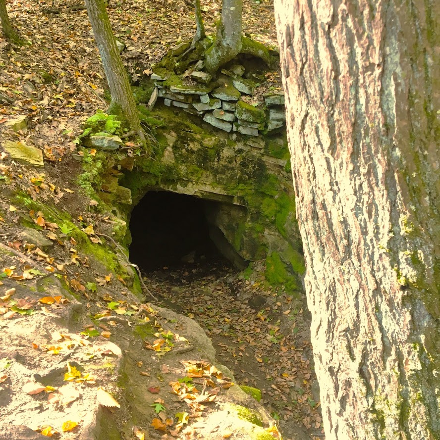
The terrain was pretty interesting and varied. This side of the loop was by far the most challenging. It was very rocky and had some steep uphill areas. As you keep hiking , you will cross paths with multiple bat cages that serve as entry ways for the caves inside them.


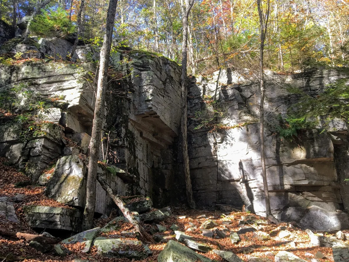
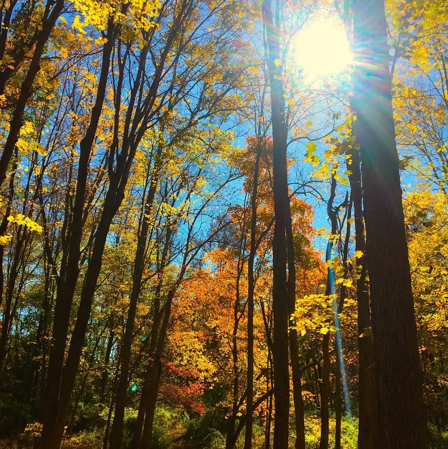
The trails begins to descend and you will meet at the Old Quarry bridge which joins a dirt road that will lead you to the other side of the loop. The other side of the loop was more of a nature path. It was flat the whole way, roughly 1.5m. This was less interesting until the end where you will find the old forge site. The fall colors kept me attentive along the way.


Overall, the historic points of the trail offered a different features you don’t get on hikes generally. The trail was very maintained and marked well. The hike would be good for anyone beginner to advanced. I would recommend hiking boots since the terrain can be rocky. The loop didn’t take us too long, about 1 hr 45 min. Next time, I would leave more time and add the additional 2m loop. Pretty good recommendation!
Review:
Mine Hill Reserve Trail, 3.6m (Roxbury, CT): 3.5 out of 5

HIKING FOR DONUTS
A blog for the outdoors foodie enthusiast
Hi, I’m Mark. I live in Connecticut. I take new trips every chance I get. A good trip has a great hike, great food, and something fun to do. My goal is to search out new trips and share them to inspire others to try something new and exciting.
If you are looking for posts in a particular place, search by city or state here.
EXPLORE OTHER POSTS IN THE ARCHIVE
Archive
RECOMMENDED POSTS
MOST RECENT POSTS
See where I have been recently on Instagram. Follow @HIKINGFORDONUTS