


Hidden Valley Preserve, Washington Depot, CT
Trail Description: The Bee Brook Loop is one of many trails in the Hidden Valley Preserve. This hike is an easy stroll along the Shepaug River. The Thoreau Bridge is the biggest attraction.
Trail Info:
Where: Washington Depot, CT Distance: 2.2m (1-1.5 hours) Difficulty: Easy Trail Type: Loop Features: Bridge, River, Water
How to get there:
198 Bee Brook Rd, Washington Depot, CT 06794
Parking lot can fit about 10-12 vehicles.
https://goo.gl/maps/Y1RQqqrmAjda6dcUA
Hiking Tips
Taking the fork to the right will bring you to the Thoreau Bridge within minutes.
There are other parking areas for different trails.
Trail map: Click Here!
The Hike
Apparently, the Washington, CT area is the mecca of public preserves in Connecticut. By mecca, I mean there’s three in a short distance of each other, which is pretty cool for nature buffs and hikers. Hidden Valley Preserve is one of three public preserves in the area owned by Steep Rock Association, along with Steep Rock Preserve and Macricostas Preserve. Hidden Valley Preserve offers 17 miles of trails consisting of various terrains and points of interest. The yellow blazed trail, known as Van Sinderen Loop Trail, will lead to the Quartz Mine and the “Lookout”, providing scenic views of the valley to the west. The Pinnacle Trail, blue blazed, also offers scenic valley views. The white blazed trail is the Bee Brook Loop, which is the quickest way to get to the Thoreau Bridge. That is the trail in this guide.
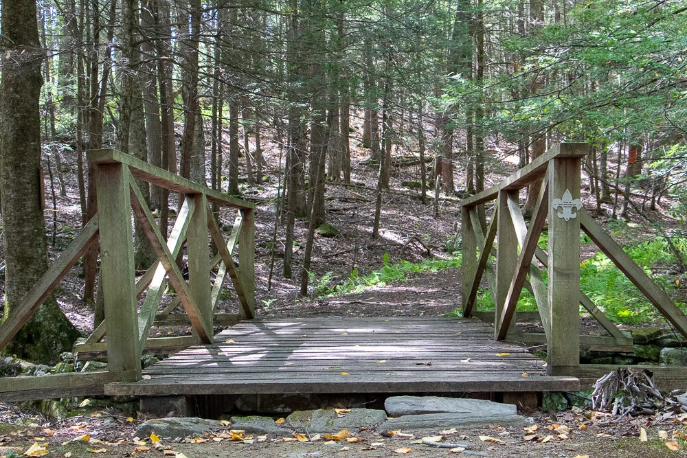
From the parking lot, there is a small footbridge that passes a small creek. This will lead to the start of the trail. There is a fork to choose your direction and we chose to go right following the White Trail for the Bee Brook Loop. Within minutes we arrived at the main attraction of the hike (for most), the Thoreau Bridge. This is a 134 foot suspension bridge hanging above the Shepaug River named in tribute to Henry David Thoreau. He was a philosopher, nature enthusiast, and advocate of hiking in the 1860s. Typically, this doesn’t do much for me nor do I get into details of history but the bridge contained many of his quotes along the railings that spoke to me.
The bridge was definitely the most busy part of this hike. It is a cool point of interest and really easy to get to. Now, I understand why it’s such a big instagram photo spot. From here, you can cross the bridge and continue onto another trail but we stayed on the White Trail hiking along the river.
Eventually, there is another wooden bridge that crosses the river on the right. This will connect you to the Yellow Trail if you want to jump on that. We just continued on the white blazed rail to finish the loop where we started. The hike was a pretty easy loop with some scenic river views. That was all I was looking for that day. Just a bit of time with nature.

HIKING FOR DONUTS
Hi, I’m Mark. I live in Connecticut. I take new trips every chance I get. A good trip has a great hike, great food, and something fun to do. My goal is to search out new trips and share them to inspire others to try something new and exciting.
If you are looking for posts in a particular place, search City or State here.
SEE OTHER POSTS IN ARCHIVE
Archive
RECOMMENDED POSTS


RECENT POSTS


See the latest on Instagram and follow @HIKINGFORDONUTS


Poets’ Walk Park, Red Hook, NY
Trail Description: Poets’ Walk Park is an easy jaunt through scenic meadows that offers wonderful views of the Hudson River and Catskills.
Trail Info:
Where: Red Hook, NY Distance: 2.4m (1.5 hours) Difficulty: Easy Trail Type: Loop Features: Views, Mountains, Water, River, Bridge
How to get there:
776 River Road, (County Road 103) Red Hook, NY
https://goo.gl/maps/y9V6GaXcWxRzqd6P9
Hiking Tips
Walk the entire loop. Many see the views of the bridge initially and turn around.
Not great phone service, so make sure to screenshot a map. Or my guide!
For trail map, click HERE.
The Hike
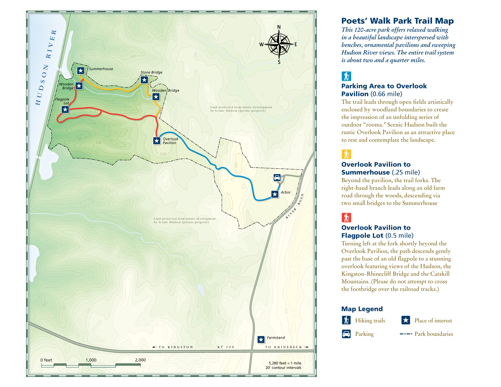
As I continue to look for the best bang for your buck views, I really don’t think it gets better than taking a stroll through Poets’ Walk Park in the fall. The Hudson Valley is full of amazing landscape and mountainous views. Most of those views require challenging hiking. However, a leisurely stroll in Poets’ Walk Park offers stunning views of the Catskills and the Kingston-Rhinecliff Bridge.
From the parking lot, begin walking on the gravel road by the trail signage. Continuing straight through the open field will lead you to a gazebo structure. Walking through the gazebo, there is the first “oh snap” view of the Kingston-Rhinecliff Bridge with the Catskills looming in the background. There is a neat little wooden bench to take a seat and enjoy the views.
The trail will split from here, where the loop begins. Either direction will bring you back to this spot. We chose left heading toward the river. Some great views of Catskills to the right and a closer view of the bridge to the left. The loop will begin on the right and suddenly you will find myself thwarted into the woods. There will be a few bridges to cross. If you need a moment of solitude, the Summerhouse gazebo area is a good spot to take a seat and look out into the mountains above the river.
From the Summerhouse structure, just retrace your steps back to the trail split and head on back to the parking lot. Easy peasy. The skies cleared on our the way back and the fall colors really popped. Just incredible views.
Depending on how long you choose to explore, take pictures, and enjoy the benches, this shouldn’t take more than an hour and half, give or take. Definitely one of those places I considered keeping to myself but the place was crazy packed. There is no secret here. It’s a spectacular park to visit for stunning views.
HIKING FOR DONUTS
Hi, I’m Mark. I live in Connecticut. I take new trips every chance I get. A good trip has a great hike, great food, and something fun to do. My goal is to search out new trips and share them to inspire others to try something new and exciting.
If you are looking for posts in a particular place, search City or State here.
SEE OTHER POSTS IN ARCHIVE
Archive
RECOMMENDED POSTS


RECENT POSTS
See the latest on Instagram and follow @HIKINGFORDONUTS

Jordan Pond Loop Trail, Acadia National Park
Trail Description: The trail is an easy hike that circles Jordan Pond with many opportunities to explore the shore and observe wonderful views.
Trail Info:
Where: Mount Desert, ME Distance: 3.4m (1.5-2 hours) Difficulty: Easy Trail Type: Loop Features: Views, Mountains, Pond, Water
How to get there:
The Jordan Pond North Parking Lot is located on the left side of Park Loop Rd at the Jordan Pond House. There is another lot next to the restaurant for additional parking as the lot fills up quickly.
https://goo.gl/maps/oQGDyrrCaNHjccsb8
Hiking Tips
Weekends are super crowded. Beware! Parking can be tough.
Post hike, eat at the Jordan Pond House. Get a popover & blueberry lemonade!
The Hike
One of the more iconic landscapes you will see at Acadia National Park is Jordan Pond. If you find yourself in Acadia, this has to be added to your list of things to check out. The shoreline of the pond has amazing views of The Bubbles, two glacially sculpted mountains at the northern end of Jordan Pond. The views are great all times of day, especially sunset and stargazing at night. Not only are the views spectacular, but the rewards of delicious food at the Jordan Pond House is almost worth the visit alone.
This was my very first trip to Acadia. I was not a happy camper to show up to nothing but fog. However, as I am learning, planning trips for national parks is impossible. You take what you can get from mother nature. Even though it was foggy, my wife and I decided to circle Jordan Pond as intended. We did have a few moments where the fog began to lift for some cool views on the pond and a tease of that fall foliage we drove 6.5 hours for! But that dissipated rather quickly. Even so, the eerie look was pretty cool.
The beginning of the trail can be found at the end of the field at the Jordan Pond House. The trail will be split as you approach. We chose to head right to stroll along the east side first. This section of the trail is more level. There are some bridges to cross over the streams that flow into the pond. As we made our way to the left side, there is a dirt trail, boulders, and a wooden plank path through the wetlands. The last 0.5m of the hike was on elevated boards, which I thought was a really cool way to protect the ecosystem. There are various points on the trail where you can hop off and explore the pond's shores. Other than that, the trail is well-marked and pretty self-explanatory.
The other great thing is that you do not need to really hike that entire trail to see some amazing views. The Jordan Pond House practically overlooks the pond. We did not get a chance to eat there the first day so we came back the next day and the weather was beautiful. I walked around the east side again briefly and I was able to see the stunning views I came here for.
Make no mistake, the views are as advertised. BUT do not, at any circumstance, miss out on a popover from the Jordan Pond House. By far, the best meal I have ever had in a national park. That popover with the jam and butter and you have to get the blueberry lemonade, magnifico! We actually tried the bison meatloaf sandwich too. Pretty damn good.
For views like this in a national park, this is as easy as it gets for a hike, or leisurely stroll. The trail is for everyone including children & dogs. It’s a great starter hike to get blood flowing or cool down after some more treacherous trails. This is a classic Acadia hike that should be added to your National Park bucket list. The view of the water with the curves of The Bubbles in the background is quite memorable. And, when you finish, it’s time for a popover!
HIKING FOR DONUTS
Hi, I’m Mark. I live in Connecticut. I take new trips every change I get. A good trip has a great hike, great food, and something fun to do. My goal is to search out new trips and share them to inspire others to try something new and exciting.
If you are looking for posts in a particular place, search City or State here.
SEE OTHER POSTS IN ARCHIVE
Archive
RECOMMENDED POSTS


RECENT POSTS
See the latest on Instagram and follow @HIKINGFORDONUTS

Jones Mountain Preserve, New Hartford, CT
Trail Description: The Vista Trail is a red-blazed loop that circles the Jones Mountain Preserve. Most of the trail is an old carriage road that leads to summit views overlooking New Hartford and the Farming River to the north.
Trail Info:
Where: New Hartford, CT Distance: 2.5m (1.5 hours) Difficulty: Easy Trail Type: Loop Features: Views, Mountains, Valley
How to get there:
161 Steele Rd, New Hartford, CT 06057
You will see the parking lot located on the right coming from Route US-44W.
Hiking Tips
For trail map, click HERE.
Stay on the trails. Lots of hunting areas surrounding.
The Hike
Once entering the nature preserve from the parking lot, there is a footbridge crossing. There will be a fork for the start of the red blazed trail. This is the Vista Trail that loops around the preserve. Going right will lead you to the summit view. After about 0.3m there is a sign with an arrow toward the peak to follow.
This part of the hike is the most difficult. There is a gradual incline with an elevation gain of 367 feet as you make your way toward the carriage road. This will last for 15 minutes or so. Reaching the carriage road will occur at about 0.5m and it is fairly easy from here. At 0.9m there is another footbridge crossing.

This will bring you to the summit of Jones Mountain at 1.5m. The lookout is a splendid view of the Farmington Valley West to New Hartford.
Continue on the red loop for the rest of the trail. Due to storms, there is a road closure at the time of our hike. This forces you to hop onto the white trail inside the preserve. The white will lead back to the red and right to the parking lot.
Based on what I saw online, there are some monuments and mill ruins along other trails in the preserve if that interests anyone reading this. We chose to just tackle the summit view.
I am enjoying finding new hiking trails in Connecticut. This trail is fairly easy, has a good view, and will get your heart pumping a little bit. Any one looking to get into hiking or just need a break from a strenuous trail, I would suggest this. Fall is officially here as I write this post. This would be a good fall hike as well once the leaves change. Get hiking!
HIKING FOR DONUTS
Hi, I’m Mark. I live in Connecticut. I take new trips every change I get. A good trip has a great hike, great food, and something fun to do. My goal is to search out new trips and share them to inspire others to try something new and exciting.
If you are looking for posts in a particular place, search City or State here.
SEE OTHER POSTS IN ARCHIVE
Archive
RECOMMENDED POSTS


RECENT POSTS
See the latest on Instagram and follow @HIKINGFORDONUTS