Hiking, Hike, CT Mark F Hiking, Hike, CT Mark F

Haystack Mountain State Park, Connecticut

Trail Description: 
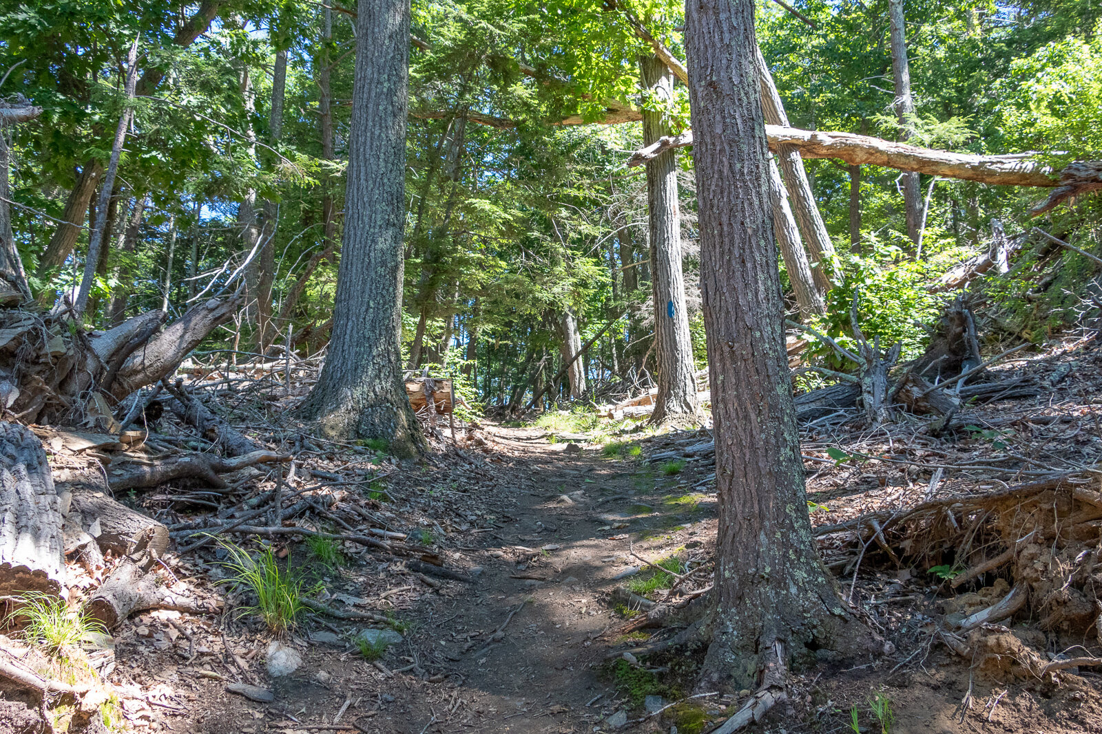
Haystack Mountain Trail contains an impressive stone fire tower with stunning views of the mountains in Connecticut, Massachusetts, New York, and Vermont.

Trail Info:

Where: Norfolk, CT Distance: 0.8 mile (30-45 min) Difficulty: Moderate Trail Type: Out & Back Features: Views, Mountains, Valley, Tower

How to get there:

Haystack Mountain State Park On Rte. 272 Norfolk, CT 06058

Trailhead parking location here.

Easy to find off Route 272. The road goes halfway up Haystack Mountain to a parking lot, where the shortest trail starts. The parking lot can hold about 10 cars or so.

Hiking Tips

  • Download park map, click here.

  • Cell phone service is spotty. Hike carefully.

  • There can be seasonal closures of the park.

The Hike

This guide will be for the shortest trail route at 0.8 miles from the top parking lot of Haystack Mountain. These days my time is a bit limited and the best bang for your buck is what is more appealing. If you want to make it a longer hike, there is the Yellow Trail that starts near the beginning of park road at the gate entrance.. This will be 1.8 miles, out and back. Both of these options will be great hikes to get to the main attraction, the amazing tower views.


Once you have parked at the top parking, which is about a mile once you enter the park, the trail is to the left to begin the summit.


This trail is fairly straightforward. It is well-maintained and clearly marked. The first 0.2 miles are flat and easy breezy. The next 0.2 miles will get your heart pumping as the trail bends to the left and starts a quick incline with 200 feet of elevation. Those quads might be on fire but it is all worth it once you see the bad ass tower at the top.


Now, it’s time to climb the 34 foot stone tower up to the top for the 360 views at 1,683 feet of elevation.


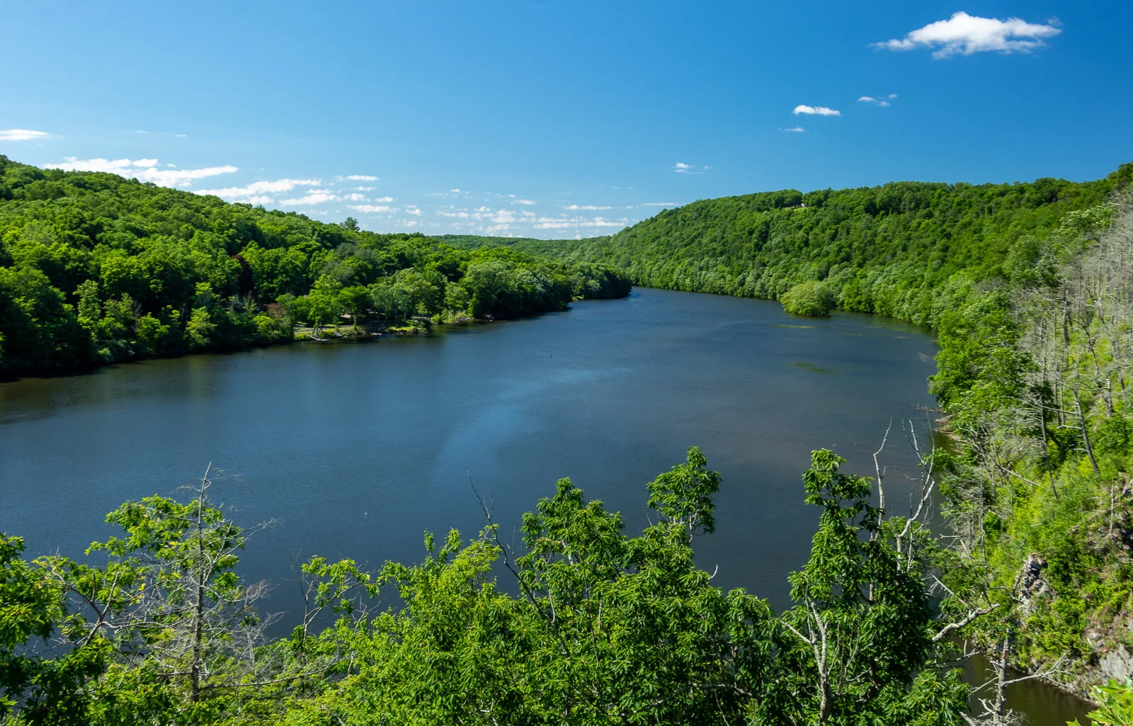
Definitely some of the best views you will have in Connecticut. It was a bit overcast and cloudy for me, but still impressive views nonetheless. On a clear day, there is visibility of the Riga Plateau in Northwest Connecticut, the Berkshires in Massachusetts, the Catskills in New York, and the Green Mountains of Vermont. That is quite a combination of views.

This would be great to pair with some other short hikes in the Litchfield County area. In addition, there are great local breweries as well such as NorBrook Farm for post hike brews.

Read More
Hike, Hiking, CT Mark F Hike, Hiking, CT Mark F

Enders Falls, Granby, CT

Trail Description: Enders Falls is a quick out and back trail with multiple picturesque waterfalls.

Trail Info:

Where: Granby, CT Distance: 1 mile (30-45 min) Difficulty: Easy Trail Type: Out & Back Features: Views, Waterfalls, Water, Brook

How to get there:

Enders State Forest Granby, CT 06035

Click here for coordinates from GoogleMaps.

Hiking Tips

  • Bring bug spray for the applicable season.

  • There are a few trails off from the parking lot heading down to Enders Brook that will converge.


The Hike

Waterfalls can be hit or miss for me. Sometimes they all just feel the same. Generally, my first inclination is to find a hike with cool summit views. However, things done changed, and that can’t always be the case. I have a toddler and many toddler nieces/nephews. I want to still get out in nature and show them all how awesome it is. And, waterfalls are a great hiking option for this. There are many in Connecticut that are accessible. I am behind on my CT waterfall game but that will likely change.


Enders Falls is an easy trail with 4-5 visible waterfalls that vary in size and look. The trail is very popular but we picked a great day and had the trail to ourselves. My wife had my daughter in a carrier and I had my nephew in my backpack carrier. And on we went to enjoy a day of nature.

From the parking lot, I definitely did not take the best course of action but we got back on track easily enough. The best start would be starting at the gravel in the far right corner by the porta potty.


There will be Purple markers (look pink to me) on the gravel trail and follow downstream to the staircase along the ravine. It seems this has been updated recently with steps of granite, fortified railings, and wooden fencing for safety purposes. It appears there were some accidents but it is very safe and well constructed. And, you can still get great views on some of the falls.


There is a good view of the 2nd waterfall and cliff area from the small viewing platform.


At the end of the staircase, there are stone steps that lead back to the gravel trail back to the parking lot for about a half mile.


Read More
Hike, Hiking, CT Mark F Hike, Hiking, CT Mark F

Horse Guard State Park, Avon, CT

Trail Description: Horse Guard State Park has one trail that is relatively quick to hike that is easy for the most part until the climb up the side of rocks that leads to stunning views of mostly trees and the Northwest hills. Fall offers a spectacular colorful viewpoint.

Trail Info:

Where: Avon, CT Distance: 1.2 miles (1 hour) Difficulty: Moderate Trail Type: Out & Back Features: Views, Mountains, Valley, Rock Scramble

How to get there:

245 W Avon Rd, Avon, CT 06001

Drive slow as you approach, the lot will come up suddenly. Depending what route you are taking, you will see a big red house, the Derrin House, right before the parking lot. The parking lot can fit maybe 8-10 cars. 

Hiking Tips

  • I would suggest hiking boots due to the muddy section and rock scramble climb. Maybe some hiking poles for the way down if not comfortable going down on the rocks.

  • Follow the white trail. If you see two trail markers, one slightly higher on the left it means make a left turn. If you see two trail markers, one slightly higher on the right, it means make a right turn.

  • It is a small park, there are no bathrooms. Close by to popular areas for post hike activities such as food and drink.

  • Trail Map here.

The Hike

There is only one way to go so this guide will be a quick one. The white marked trail is the only trail at Horse Guard State Park.

Once parked, it is pretty clear where to hop on the trail and there is a trail map right before the trail begins.

The white trail is well-marked and easy to identify. Also, the trails are very wide.


It is an easy hike up until the rock scramble. There is a section that will be quite muddy but you can go around it if you choose wisely. I did not the first time and my foot definitely submerged into the mud.


This is such a beautiful park in the fall just walking through the forest.


At about 0.4 miles, you will start approaching the rock scramble portion of the hike. This will be 0.2 miles of about 500 feet elevation. This is what makes the hike a moderate one to me. The rock scramble is short, but like a straight up ascent. It definitely gets the blood going and is not easy. Coming down was way harder. There may be markings for the proper direction to go up but I just went for it.


At the top of the rock scramble, there will be a small narrow trail to the left to take. After a short walk, you reach two lookouts. The first one is an appetizer.


The next lookout is literally a few steps over and that is just….boom. Fall colors to the face! Just an unbelievable view of the open forest covered by trees everywhere and rolling hills in the background.

Most people stop here but I saw some hikers continue on a very narrow and not clear trail. This short walk actually led to another view where you can see the Heublein Tower on Talcott Mountain in the distance. Also, it appears you are on a cliff above someone’s house. I prefer the other views but this was a bonus. From here, just return the way you came and down the rock scramble to the parking lot.

As mentioned above, this is close to a popular area in Avon, CT. There is a brewery about 5 min or so close by, Hopmeadow Brewing Company. My wife and I stopped there for some post hike beers and there was a delicious food truck there as well. The beers were great, I highly recommend visiting.

Read More
Hiking, CT, Hike Mark F Hiking, CT, Hike Mark F

Meeker Trail, Macricostas Preserve, New Preston, CT

Trail Description: The Meeker Trail is the most popular hiking trail in the Macricostas Preserve that includes views from the Macricostas Lookout and eventually stunning vistas at Waramaug’s Rock summit.

Trail Info:

Where: New Preston, CT Distance: 3.2m (2 hours) Difficulty: Moderate Trail Type: Out & Back Features: Views, Mountains, Valley, Lake, Water

How to get there:

124 Christian St, New Preston, CT 06777

https://goo.gl/maps/bL3cHowWumEohJn26

Once you get to Christian Street, look for the red house and the trailhead is behind this house. There are markers and the lot is visible from the street. 

Hiking Tips

  • Bring bug spray!

  • Download a copy of the trail map here. Cell service can be spotty or non-existent.

  • There are multiple trail options at this preserve. This guide is for the out & back using the yellow trail. You can add the orange trail to make it a loop.

  • One of the better marked trails in CT but keep an eye out to make sure to follow the color markers.

The Hike

From the parking lot, the Kiosk for the start of the trail is visible past the boardwalk. Follow the yellow trail on the right. The Meeker Trail is 1.6 miles to Waramaug’s Rock summit.

The trail starts easily crossing a bridge and footbridge through the meadow (pretty buggy here).


This will lead to the trail marker to take a left onto yellow and continue walking along the hayfield.


Proceed to follow the yellow trail markers as the Meeker Trail turns left through Meeker Swamp on wooden planks crossing another bridge and continues along the planks.

In roughly 0.2 miles, the trail comes to an intersection with the orange marked Ridgeline Trail. Stick to the right to resume on the Meeker Trail following the yellow trail.


At this point, the trail ascends gradually then becomes steeper along some switchbacks. There is a junction that passes the white trail but continue to follow the yellow trail.

The first viewpoint will be the Macricrostas Lookout at 1,092 feet elevation with views of the hayfield below and surrounding area.

From here, continue on the yellow trail as the ascend to Waramaug’s Rock becomes much steeper.


After about 0.4 miles, the trail reaches a rock slab to climb to the summit of Waramaug’s Rock.


Waramaug’s Rock reaches an elevation of 1,280 feet with an amazing panoramic view of Lake Waramaug and the surrounding valley. There is the one dead on center view but do some exploring at the summit to see all the views to the left (southwest) as well.

After all the views are soaked in, head back the same way down the yellow trail. At 0.4 miles, there is a junction to continue on the yellow trail going the same way or hop on the orange trail to do a loop back down to the parking lot. This will add 0.7 miles to the hike. It was pretty hot and beers were calling my name at Kent Falls Brewing so I decided to just do an out and back.


HIKING FOR DONUTS

Hi, I’m Mark. I live in Connecticut. I take new trips every chance I get. A good trip has a great hike, great food, and something fun to do. My goal is to search out new trips and share them to inspire others to try something new and exciting.

If you are looking for posts in a particular place, search City or State here.

SEE OTHER POSTS IN ARCHIVE

RECOMMENDED POSTS

RECENT POSTS

See the latest on Instagram and follow @HIKINGFORDONUTS

Read More
Hike, Hiking, CT Mark F Hike, Hiking, CT Mark F

Lovers Leap State Park, New Milford, CT

Trail Description: Lovers Leap State Park has multiple hiking trails with views of the Housatonic River and other structural landmarks such as the popular Lovers Leap Bridge.

Trail Info:

Where: New Milford, CT Distance: 1.8 miles (1.5 hours) Difficulty: Moderate Trail Type: Loop Features: Views, Valley, Bridge, Lake, River

How to get there:

178 Short Woods Rd, New Milford, CT 06776

https://goo.gl/maps/4FUFjzSinExpgzHfA

Hiking Tips

  • Click here for trail map

  • Be cautious switching trails. If markers cannot be found, turn back to retrace steps. Also, the blue trail appears to have a fake marking on top of the hill toward the wrong direction.

  • Don’t just hike up to the popular scenic view & leave. There is another cool view from the East on the Blue trail.

The Hike

Lovers Leap State Park is pretty easy to find. The parking lot is pretty big as this does seem like a busy hike. The wife and I caught a good time of day as the lot was almost empty. From the parking lot, we headed towards Lovers Leap Bridge. The bridge will appear pretty immediately. The structure is interesting. The lighting was spotty with shadows so I did not successfully get the best picture for the insta. Darn it!

Lovers+Leap+State+Park+Connecticut

We crossed the bridge and got the first view of the Housatonic River. Taking a right off the bridge took us down a gravel road, also known as the Lovers Leap Trail. Within 0.3 miles of some incline, the money shot picture awaits. This scenic view offers the best one in the park overlooking Lake Lillinonah. From here, you could take your donut and go home, but there is some more hiking to be had at this park.

Lovers Leap State Park

There are some interesting features and landmarks on some of the other trails. We decided to trace back our footsteps on the gravel road until we noticed the red markers for the Castle Trail on the right. Have a map handy, we had an issue finding. Pretty sure we did not go the way intended but it worked. The red blazed was a pretty good incline. Got my lungs working. Within a short distance, we came upon the castle ruin, which was just its foundation and a tall chimney. And, across from this was a castle-like turret. As I try to sit here explaining it, here’s a picture. If you must know more, I suggest the google machine.

Lovers Leap State Park
 
Lovers Leap State Park Connecticut
 

In between the castle features, there is a trail we took that connects the red blazed trail to the blue blazed trail, known as the Falls Mountain Trail. We took a right from the red to the blue. This took us up a steeper hill.

Lovers Leap State Park Connecticut

Once we reached the top of the hill, we saw a blue marker to the left but that was not correct. We met just bushes and the end of a ledge. It appears that it was painted incorrectly as a joke perhaps. That could be very dangerous if you are not paying attention. This is why we can’t have nice things. That person sucks who did that. Fortunately, we found other lost hikers and we noticed the view was behind us and we needed to retrace our steps and keep going straight and the ridge is on the right. From the ridge line, there is an open area view from the east that is pretty nice. From here, we retraced our steps down the blue to the red trail back to the gravel road.

Lovers Leap State Park Connecticut

Bonus Foodie Find: 

After hiking, the post meal is important. Not all hikes are near donut shops unfortunately. However, other great food spots can be found. This hike is close to the downtown area of New Milford, CT. We stopped at Johana’s Restaurant for a brunchy meal. Great menu. I got the English Scramble - eggs, bacon, scallions, cheddar cheese in a skillet with home fries. Hell yes. And, my wife got the corn cheddar pancakes. That’s how we get down. Everything was delicious. Also, if you go in the warmer months, check out the farmers market. There’s an awesome bread company there.


HIKING FOR DONUTS

Hi, I’m Mark. I live in Connecticut. I take new trips every chance I get. A good trip has a great hike, great food, and something fun to do. My goal is to search out new trips and share them to inspire others to try something new and exciting.

If you are looking for posts in a particular place, search City or State here.

SEE OTHER POSTS IN ARCHIVE

RECOMMENDED POSTS

RECENT POSTS

See the latest on Instagram and follow @HIKINGFORDONUTS

Read More
Hike, Hiking, CT, US Mark F Hike, Hiking, CT, US Mark F

Rattlesnake Mountain to Pinnacle Rock via Metacomet Trail, Farmington, CT

We headed on the trail to our left toward the Rattlesnake Cliffs. The trail starts out flat then begins to switchback up the side of the mountain. After a half mile in, the trail will ascend uphill and the terrain is rockier. We passed lots of large rock boulders as we got closer to the cliffs. This particular trail was very well-marked. We eventually came across the boulder rock cave known as Will Warren’s Den, which I later found out was a historical site.

Looking for a good hike in Connecticut?  Well, I stumbled upon a hidden gem right under my nose. Rattlesnake Mountain to Pinnacle Rock trails are located in Farmington, CT and crosses over to Plainville, CT. This is part of the New England/Metacomet Trail. Finding the parking area can be tricky. There are 2 areas where you could start. Blue trail markers can be accessed from Pinnacle Street in Plainville. The GPS wasn’t picking this option up so my girlfriend and I chose to drive on RT 6 in Farmington. There is a small parking area on your right where the trail starts. If you GPS 200 Colt Hwy Farmington, CT 06032, that should find it.

Parking area off route 6.

Parking area off route 6.

From here, you can hike to the Rattlesnake Cliffs, which is a 2.6m out and back loop. Or you can continue to hike another 2 miles out and back to Pinnacle Rock. Thus, it will be 4.6m total for this hike.

HIKING FOR DONUTS

A blog for the outdoors foodie enthusiast

Hi, I’m Mark. I live in Connecticut. I take new trips every chance I get. A good trip has a great hike, great food, and something fun to do. My goal is to search new trips and share them to inspire others to try something new and exciting.

If you are looking for posts in a particular place, search by City or State here.

Explore other posts in the archive.

Start of trail

Start of trail

Once parked, we headed on the trail to our left toward the Rattlesnake Cliffs. The trail starts out flat then begins to switchback up the side of the mountain. After a half mile in, the trail will ascend uphill and the terrain is rockier. We passed lots of large rock boulders as we got closer to the cliffs. This particular trail was very well-marked. We eventually came across the boulder rock cave known as Will Warren’s Den, which I later found out was a historical site.

Not long after this, we reached the Rattlesnake Cliffs. Wow, what a spectacular view. I was absolutely stunned.  On our left, we could see as far as the city of Hartford. And the sky was clear, so we could visibly see the biggest buildings in downtown Hartford. On our right, we could see the East and West Peak at Hubbard Park in Meriden and the Pinnacle Rock in Plainville. Great views all around. How did I not know this view existed? If this was all we did, I would have still ranked this hike very high on my list of CT hikes.

Views from Rattlesnake Cliffs.

Views from Rattlesnake Cliffs.

hartford views to the left from the cliffs.

hartford views to the left from the cliffs.

On your RIght from the cliffs.....

On your RIght from the cliffs.....

PANO VIEW FROM RATTLESNAKE MOUNTAIN CLIFFS.

PANO VIEW FROM RATTLESNAKE MOUNTAIN CLIFFS.

We hopped back on the blue trail down Pinnacle Rock and started making a steep descent.  We witnessed other hikers take a wrong turn here by going straight down. We were able to stay on track. We continued hiking along the bottom of Rattlesnake Mountain and noticed a small tunnel formed by the rocks. We decided to climb through and found ourselves blue markers on the other side. Note, this is how you to get to Pinnacle Rock. There is a quite a bit of climbing on and over rocks for this section.

And, this trail is not as well-marked. There were areas we lost the blue markers. Sometimes the blue marker was faded on rocks and we didn’t notice until we got closer.  If you do not come across blue after 5 min or so, I suggest turning around.

If you can't find blue markers, they may be on the rocks.

If you can't find blue markers, they may be on the rocks.

We reached the bottom and crossed an area under power lines that led us climbing up to the other side. We reached a dirt paved road and we saw a tree marked with blue and red. This took us to the final section before we reached Pinnacle Rock. You will be going uphill and start climbing the rock on your right to the peak of Pinnacle Rock.

The view of Pinnacle Rock is nice. But Rattlesnake Mountain has a higher wow factor. The view from Pinnacle Rock is not as appealing as you will see mostly homes. This is a big rock climber’s paradise and I did see a few people doing so. I will hike all day. But climbing isn’t for me.

RECOMMENDED POSTS

RECENT POSTS

See where I’ve been recently on Instagram, follow @HIKINGFORDONUTS

Crazy guy climbing up pinnacle rock.

Crazy guy climbing up pinnacle rock.

 
VIew from the pinnacle Rock summit.

VIew from the pinnacle Rock summit.

 
Top of pinnacle Rock with railings and rock seating to enjoy the views.

Top of pinnacle Rock with railings and rock seating to enjoy the views.


We headed back the same way we came. Took another peek from the Rattlesnake Cliffs before we headed back to the car. Such a great view. That is one of best views in CT. I was very impressed by this hike. This is easily one of my favorites now. It is very challenging. I would say it’s a moderate hike.  Lots of different terrain and some climbing. Round trip is 4.6 miles but I feel like it’s closer to 5 miles. Definitely suggest hiking boots and a pack for this one. This took us about 3 hours. This is one New Englanders should add to their hiking list!

The review:

Rattlesnake MT to Pinnancle rock (farmington, CT), ~4.6m: 4.5 out of 5.

 
Read More
Hiking, Hike, CT, US Mark F Hiking, Hike, CT, US Mark F

Black Pond via Mattabesett Trail, Middlefield, CT

The Mattabesett Trail extends through the state of Connecticut. Along this trail, there are great views. Black Pond has an amazing view from Besek Mountain. Check out the blog for pics and helpful info!

Mattabassett Trail Black Pond cliffs Middlefield CT
img_1287-1.jpg

The Mattabesett Trail extends over 50 miles throughout the state of Connecticut. The first half of this horseshoe like trail follows high trap rock ridges of the Metacomic Ridge, from Guilford south to Meriden. The second part extends extends north from Guilford to Middletown where it ends at the Connecticut River. There are multiple areas throughout the state to hop on the trails. You will find numerous picturesque views along the way. One of my favorites spots to check out is Black Pond in Middlefield. I came across this trail a few years ago and the views are spectacular.

For the directions, the trail starts on Baileyville Road (RT 147) that intersects Meriden Road (RT 66). I always gps the restaurant Guida’s across from the trail. I park there and cross the street or there is a little parking area off the side of the road, where you will find the Mattabesett Trail blue-blazed marker.

 
Hiking for Donuts: Mattabassett Trail Connecticut
 

Once we saw the marker, we headed into the woods to begin the trail. The trail is well maintained and marked pretty well. Thus, just follow the blue markers on this one. Nothing too tricky on this trail. Due to the storms recently, we saw quite a bit of trees down throughout the hike. And there are areas of rock formations where snakes may be hiding. Be on the lookout, I almost stepped on one.

 
Start of Black Pond Trail Middlefield, CT
 
 
Mattabassett Trail Black Pond Middlefield CT
 

About three-quarters of a mile into the hike, we came out to an open field that led us under power lines. We could see Route 66 highway from here, as the trail runs parallel to the highway. We then passed a brick and stone chimney along the way.

 
Mattabassett Trail Black Pond Middlefield CT
 

From here, the trail will begin to ascend up the mountain.

 
Mattabassett Trail Black Pond Middlefield CT
 

Until I was researching the area, I wasn’t aware this was called Besek Mountain. And, there is a ski area next to it, Powder Ridge. Once you reach the cliffs, you see the stunning view of Black Pond and Mount Higby in the distance as well. You can continue the trail from here and follow the blue-blazed trail further past the ski area chair lifts and the true summit of Besek Mountain. And you can go all the way to Guilford. However, this is where we stopped and turned around. We had our fun taking pics and checking out the view.

 
Hiking for Donuts: Mattabassett Trail Black Pond Middlefield CT views
 
 
Hiking for Donuts: Mattabassett Trail Black Pond cliffs  Middlefield
 
 
Mattabassett Trail Black Pond cliffs Middlefield CT
 
 
Mattabassett Trail Black Pond cliffs Middlefield CT
 

The loop was roughly 2.8 miles. The hike was moderate difficulty. The terrain was easy in the beginning but had some up and down sections. The hardest part may be finding the trail. This is a great morning weekend type hike with a rewarding view. Be sure to add this to your list, especially if you are local.

 
Hiking for Donuts Mattabassett Trail Black Pond Middlefield CT
 

The Review

Black Pond via Mattabesett, 2.8M (Middlefield, CT) - 4 out of 5

HIKING FOR DONUTS

A blog for the outdoors foodie enthusiast

Hi, I’m Mark. I live in Connecticut. I take new trips every chance I get. A good trip has a great hike, great food, and something fun to do. My goal is to search out new trips and share them to inspire others to try something new and exciting.

If you are looking for posts in a particular place, search by city or state here.

EXPLORE OTHER POSTS IN THE ARCHIVE

RECOMMENDED POSTS

MOST RECENT POSTS

See where I have been recently on Instagram. Follow @HIKINGFORDONUTS

Read More
Hike, Hiking, CT, US Mark F Hike, Hiking, CT, US Mark F

Old Furnace State Park, Killingly, CT

Old Furnace State Park is located in Killingly near Rhode Island. This is a great park for hiking, biking, and fishing. Exploring new areas is always fun, even if you get lost on the trails. Check out the blog to make sure you stay on the trails!

img_6666.jpg
 
Old Furnace State Park entrance Killingly, CT
 

Scrolling through the list of the 2018 Sky’s Limit Hiking Challenge in Connecticut, I wanted to explore unknown parts of the state that would be new to me. I haven’t spent much time in the Windham County area, neighboring Rhode Island.  I really had no idea where I was going and there was not too much info on the park online. But, I convinced my girlfriend to drive over an hour with a promise of beers and off we went.

Old Furnace State Park is located in Killingly, CT. You will find the park entrance off Route 6 via Route 395. Ross Pond State Park is fairly close so my GPS took me there instead. If yours does the same, just keep going past that until you can take a left onto South Frontage Road and the park will be there on your left.  The blue-blazed trail of this park runs about 3 miles. This particular hiking challenge calls for 2 miles round trip until you reach the overlook from the cliffs at 200 feet over Half Hill Pond. With this view you get a great look of valley stretching into Rhode Island.

 
Old Furnace State Park trail map Killingly, CT
 

We finally found the parking lot and noticed there was mountain biking event going on. Apparently, this is a big mountain biking trail. I didn’t expect to see anyone. The hiking trail starts at the parking lot.  I used the trail located at ct.gov here . The path instantaneously takes you into the woods.

 
Old Furnace State Park Trail Killingly, CT
 

As we began, we crossed a small brook that led us to crossing a small footbridge.

 
Old Furnace State Park Killingly, CT
 
 
Old Furnace State Park Killingly, CT
 
 
Old Furnace State Park footbridge Killingly, CT
 

The trail was fairly wide open until we reached an unmarked section ducking through a brush of bushes. We found ourselves questioning our direction. Eventually, a blue marker did appear.

 
Old Furnace State Park Killingly, CT
 
 
Old Furnace State Park Trail Killingly, CT
 

From here the ascent started to get steep. About a mile into the hike, we saw the path break into two. Unfortunately, we kept going straight and that was not correct and saw some brown marked trails.

 
Old Furnace State Park Trail Killingly, CT
 
 
Old Furnace State Park Killingly, CT
 

Thus, we circled back and took the path to the left which was the ridge along the pond. And, finally we found ourselves at the cliffs overlooking Half Hill Pond.  The pond was completely filled with water lilies.

 
Old Furnace State Park Killingly, CT Half Hill Pond
 
 
Old Furnace State Park Killingly, CT Half Hill Pond
 
 
Old Furnace State Park cliff views Killingly, CT
 
 
Old Furnace State Park Killingly, CT Half Hill Pond
 
 
Old Furnace State Park Killingly, CT Half Hill Pond
 

We stopped here because the trail was pretty buggy and I didn’t think the rest of the trail would offer much. But if you want to continue, this will lead you down to the parking lot and boat ramp at Ross Pond to Squaw Rock Road where you turn around and come back.  If you are not from the area, the directions to the park could be difficult and the trail itself has areas that should be marked better. The hike itself was not hard. I would rate it easy. I would bring bug spray and pay very close attention for the blue markers. Looks like a good area to fish and maybe kayak as well. I’m sure this is a nice spot for locals but one time is probably enough for me.

The Review

Old Furnace State Park, Blue Trail, Killingly, CT (~2m): 2.5 out of 5.

HIKING FOR DONUTS

A blog for the outdoors foodie enthusiast

Hi, I’m Mark. I live in Connecticut. I take new trips every chance I get. A good trip has a great hike, great food, and something fun to do. My goal is to search out new trips and share them to inspire others to try something new and exciting.

If you are looking for posts in a particular place, search by city or state here.

EXPLORE OTHER POSTS IN THE ARCHIVE

RECOMMENDED POSTS

MOST RECENT POSTS

See where I have been recently on Instagram. Follow @HIKINGFORDONUTS

Read More
Donuts, CT, US Mark F Donuts, CT, US Mark F

Tastease, Hartford, CT

If you want to know where to find delicious mini donuts in CT, check out my latest blog!

img_0044.jpg
 
Tastease Donut Hartford, CT
 

It has been a while, but it is time for more donut reviews!! I recently tried a new donut shop sort of close by.  Nichole and I had a Derby de Mayo party and bringing 36 delicious mini donuts was the only way to go. I heard quite a bit of good things about Tastease, located in Hartford, CT on the Parkville side of town. I dragged myself out of bed at 7:30 a.m. on a Saturday morning just to make sure I got some donuts. They have shorter hours so I assumed the earlier you get there, the better.

We made our way into the donut shop and we were the first customers! All the donuts to choose from, waiting just for me. Tastease is known for mini donuts. They have a plethora of options. All the toppings, glazes, fillings, and flavors are pre-made when you get there. And, of course I had individually selected each donut and asked 5 questions about each one.

 
Tastease Donut Hartford, CT
 

The woman working that morning was super friendly. She randomly gave us a donut to try and it was by far the best one, chocolate donut with chocolate frosting with raspberry filling. I was really excited to try the rest. And midway I realized there was a line forming behind me. And, Nichole told me to pick up the pace but I'm the worst with donut decisions. We got there at the right time. Nichole bought a coffee which came with a free donut. She chose the vanilla cake donut with caramel frosting and chocolate drizzle with a marshmallow in the center , also pretty good.

Tastease Donut Hartford, CT

Everyone at the party enjoyed them. I tried to have as many as I could. All the ones I had I liked. I could have had like 20. They are the perfect size. They aren't overly sweet. And, the cakey texture was delish.  All the different donut cake flavors worked well.  Again, the chocolate raspberry was the best. The coffee cake flavored were really good and the maple too. They had a German chocolate cake one that wasn't too bad either.

 
Tastease Donut Hartford, CT
 

The type of donuts they make are:

  • Vanilla cake donut

  • Chocolate cake donut

  • Blueberry

  • Cherry

  • Red velvet

  • Orange

  • Dirty donut ( tastes like candy)

  • Glazed

  • Cinnamon sugar

  • Apple

The toppings that you will find on them:

  • Chocolate Chip

  • Cookie Dough

  • Cinnamon Toast Crunch

  • Fruit Loops

  • M&Ms

  • Mini Lucky Marshmallow

  • Rainbow Sprinkles

  • Raspberry Jelly

  • Toasted Coconut

  • Coconut

  • German Chocolate

  • Oreo

  • Carmel Crunch

  • Lemon

 
Tastease Donut Hartford, CT
 

The donuts definitely exceeded my expectations. I drove by this location probably multiple times. Who knew what I was missing? Seriously, why didn't anyone tell me? And, I heard they make a pretty good cuban sandwich. I will be back because I have at least 30 more flavors combinations to try. Big thumbs up here.

HIKING FOR DONUTS

A blog for the outdoors foodie enthusiast

Hi, I’m Mark. I live in Connecticut. I take new trips every chance I get. A good trip has a great hike, great food, and something fun to do. My goal is to search out new trips and share them to inspire others to try something new and exciting.

If you are looking for posts in a particular place, search by city or state here.

EXPLORE OTHER POSTS IN THE ARCHIVE

RECOMMENDED POSTS

MOST RECENT POSTS

See where I have been recently on Instagram. Follow @HIKINGFORDONUTS

Read More
Hike, Hiking, CT, US Mark F Hike, Hiking, CT, US Mark F

River Highlands State Park, Cromwell, CT

This is the first hiking trail review on the Connecticut hiking challenge trails. Check out the blog to learn more about the challenge!

Trail Description: A view 150 feet up of the Connecticut River can be seen from the White Blazed Trail in the River Highlands State Park. In addition, there is water front with picnic tables to enjoy.

Trail Info:

Where: River Highlands State Park, Cromwell, CT Distance 1.5 miles (1 hr) Difficulty: Easy Trail Type: Loop Features: Views, River, Water

How to get there:

Directions in detail can be found here,https://www.ct.gov/deep/cwp/view.asp?a=2716&q=434748&deepNav_GID=1650.

River Highlands State Park, Field Rd, Cromwell, CT 06416

Hiking Tips

  • Good beginner hike or weekday hike after work.

  • Super buggy area. Bring bug spray.

River Highlands State Park, Cromwell, CT

The Hike

Finding good hikes in Connecticut is becoming less a challenge. And, that is a good thing. Most people just dismiss how much is truly out there. Recently my friend told me there is a hiking challenge in CT. I can’t believe I haven’t come across this. Of course, I googled and found Sky’s the Limit Hiking Challenge by the CT Department of Electric & Environment Protection (DEEP). They list 14 lesser known trails to encourage more hiking in CT state parks. There are rules and info here. You can win some prizes too. I think it is a great idea. I haven’t heard of most of the trails. I smell some new blog material. I am definitely on-board and will be joining in on the fun.

With that said, here in my very first hike of the Sky’s the Limit challenge. A rare weekday hike but if it is 90 degrees in May in CT, you get outside. Nichole and I went to River Highlands State Park in Cromwell, CT. This was an easier and quick hike. The hike offers views of the Connecticut River from 150 feet above the water. I would use this link for the trail maps. Directions can be found on the CT DEEP link above.

River Highlands State Park, Cromwell, CT
 
Trail Map River Highlands State Park, Cromwell, CT
 

The park consists of multiple color trails. You can go multiple different directions. The biggest loop will take you about 2 miles but you can connect to many different trails and adventure as much as you want. The trails are very well marked and the terrain is pretty level. Maybe one or 2 short, steep sections. We chose the white trail from the parking lot. This takes you directly to the high bluffs overlooking the Connecticut River.

 
River Highlands State Park, Cromwell, CT


More river views.

From there we took the yellow trail down to the camping site. Typically, you can go to the bottom and walk out to get more views of the river. However, due to all the rain we had recently, the water was really high. Trees and picnic tables were covered. It is probably best to do this hike in the summer. Luckily, I did this a few years ago when the water was low.

 
River Highlands State Park, Cromwell, CT
 
 
River Highlands State Park, Cromwell, CT
 

After trying to snap some good IG pics, we continued to follow the yellow trail out to the parking lot. There are quite a bit of small bridges to cross over. And, this particular area is swampy and gets very buggy. Tons of mosquitoes. I suggest Deep Woods spray for this hike.

 
River Highlands State Park, Cromwell, CT
 
 
River Highlands State Park, Cromwell, CT
 

We did do some adventuring off the trails mentioned but it shouldn’t be more than 1.5 miles if you use the white to yellow marked trails. Barely took us an hour. This is a very good beginner hike. You don’t need boots but it is a wetlands area so it can be very muddy. It’s a good, quick hike for those locally.

HIKING FOR DONUTS

A blog for the outdoors foodie enthusiast

Hi, I’m Mark. I live in Connecticut. I take new trips every chance I get. A good trip has a great hike, great food, and something fun to do. My goal is to search out new trips and share them to inspire others to try something new and exciting.

If you are looking for posts in a particular place, search by city or state here.

EXPLORE OTHER POSTS IN THE ARCHIVE

RECOMMENDED POSTS

MOST RECENT POSTS

See where I have been recently on Instagram. Follow @HIKINGFORDONUTS

Read More
Hike, Hiking, CT, US Mark F Hike, Hiking, CT, US Mark F

Hancock Brook Trail, Waterbury, CT

Spring weather is finally upon us. As summer approaches, I look forward to finding new hiking trails. I came across Hancock Brook on Instagram and the hike surprised me. And, no it's not closed. Read up on my advice to make sure you complete this trail!

img_6138.jpg
Hancock Brook Trail, Waterbury, CT

It has been a long, very long winter in the Northeast. The weather finally felt like spring and that means it was time to find some new trails to hike. I came across the Hancock Brook Trail in Waterbury, CT on Instagram from some fellow CT hikers I follow. I never heard of it and the views looked cool. However, my research displayed this trail was closed including sites like Alltrails. After seeing recent posts and finding one actual site with directions on this trail, I felt comfortable enough to give it a go. And, I can confirm the trail is NOT closed. People are giving up too easily. Yes, there is a rotted bridge but the trail can be accessed elsewhere. For directions, plug into your GPS: Sheffield St., Waterbury, CT, 060704. Drive all the way down until you hit the quarry and there is a small parking lot to your right.

The Hancock Brook Trail is a blue-blaze trail along the edge of the Mattatuck State Forest.  This hike is a 2.8 mile loop. The terrain does get quite rocky, which includes steep uphill and downhill portions and some climbing. The trail was covered in leaves on this day and was quite slippery because of that. I would consider this a moderately difficult hike for the average hiker.

 
Hancock Brook Trail, Waterbury, CT
 

Onto to the infamous bridge I kept reading about. Ignore the bridge.

 
Hancock Brook Trail, Waterbury, CT
 

From the parking area, you will start walking up the side of the quarry and look for the first Blue marker. Upon entering the woods, the trail splits and the trail to the right with one blue marker will take you along Hancock Brook. The first half mile or so will give views of the stream and its rapids. The trail is fairly narrow and gets unpleasant as you reach the inclines where the bushes have grown into the trail.

 
Hancock Brook Trail, Waterbury, CT
 
 
iHancock Brook Trail, Waterbury, CT
 

You will reach a spot in the trail where you hear lots of trucks and work on the quarry.  There will be a sign to stay on the blazed trail on a tree with the Blue marker.

 
Hancock Brook Trail, Waterbury, CT
 

Continue this direction and go straight. This is a tricky part of the trail. The markings are not great until you reach the peak. You will want to veer right but that will take you the wrong way. There is a like a raised branch signaling not to go this way. If not, you will reach a small pond and you will see a very sketchy trailer. Do not go there. That is not part of the trail. You will be too close for comfort. Turn around. I just envisioned all the crazy TV shows I saw with a crazy dude coming out of a trailer and chasing me.

 
Hancock Brook Trail, Waterbury, CT
 

If you went the right way, you will reach the pond and see the trailer across far enough away. You need to make an abrupt left into the woods to start the incline.  Once you do not see blue markings, stop and just turn around. We walked by it as well. I took pictures for guidance. The blue marker was covered by trees.

The trail will get tougher at this stage as you enter a pine forest. There is a mini pond with a bunch of trees down as you get closer to the ascend uphill. Keep an eye out for the blue markings. They are a little too far apart in this area. Once you pass this pond, the steep uphill will begin and there will be some switchbacks.

 
Hancock Brook Trail, Waterbury, CT
 

This tough stretch will be worth it as you will reach a beautiful lookout spot for views. The rock formation is called Lion Head and is the peak at 660 feet. This is a great spot to stop and soak in nature. Have a snack and fuel up on water. Maybe eat a donut.

Hancock Brook Trail, Waterbury, CT
 
Hancock Brook Trail, Waterbury, CT
 

The climb down was tough at first but got pretty easy as we kept going. And, the trail markings were way better. The spots where they were too far apart, I suggest going the way that made sense and you will find them. You will pass a few more lookout points to enjoy more views along the way.

 
Hancock Brook Trail, Waterbury, CT
 
 
Hancock Brook Trail, Waterbury, CT
 

At the end of trail, there will be a steep downhill section before you reach the quarry where you started.  And, somehow we completely missed the waterfall coming in, or the water started to come down from melting while we hiked. Before we left, we took a closer look at what is called Hancock Cascades. This was to the left at the end of the final descend.

 
iHancock Brook Trail, Waterbury, CT
 
 
Hancock Brook Trail, Waterbury, CT
 

This was a surprisingly good hike. This took us about 2 hours and that is with stopping for 20 minutes.  I don’t think I would have found it without Instagram. The hike was fun and didn’t take too much time.  I would just be careful of the markers. There were times where it was lacking and you really had to keep an eye out. And, stay away from the Breaking Bad looking trailer!

Trail Review:

Hancock Brook Trail, Waterbury, CT (2.8m): 3 out of 5

 
Hancock Brook Trail, Waterbury, CT
 

HIKING FOR DONUTS

A blog for the outdoors foodie enthusiast

Hi, I’m Mark. I live in Connecticut. I take new trips every chance I get. A good trip has a great hike, great food, and something fun to do. My goal is to search out new trips and share them to inspire others to try something new and exciting.

If you are looking for posts in a particular place, search by city or state here.

EXPLORE OTHER POSTS IN THE ARCHIVE

RECOMMENDED POSTS

MOST RECENT POSTS

See where I have been recently on Instagram. Follow @HIKINGFORDONUTS

Read More
Hike, Hiking, CT Mark F Hike, Hiking, CT Mark F

Sunset Rock State Park, Crescent Lake, Southington, CT

Check out the Crescent Lake trail in Southington, CT. This was a confusing trail but well worth the views. Enjoy!

Trail Description: Sunset Rock State Park offers a scenic hike around Crescent Lake that connects to the Metacomet Trail.

Trail Info:

Where: Southington, CT Distance 3.2 miles (2-2.5 hrs) Difficulty: Easy to Moderate Trail Type: Loop Features: Views, Lake, Water

How to get there:

Address to GPS: 357 Shuttle Meadow Rd, Plainville, CT 06062. Parking lot is easy to find.

Hiking Tips

  • Three trails to choose from. The Blue to Orange trail takes you above the lake and is rockier and steeper. Much better views.

  • Be mindful if you lose the trail markings or end up on a different trail. There is a lack of trail markings. And, some confusing areas where trail markers change colors.


The Hike

On this brisk fall weekend, we decided to hike the Crescent Lake Trail in Southington, CT. This is one of those trails that there isn’t the best information online and it is poorly marked. I will do my best explaining but my advice is always have the map handy and make sure someone is good at directions!

The parking lot is easy to get to, it is off Shuttle Meadow Road. Once you park you will see the lake right in front of you and potentially some people fishing.  There are 3 trails. The Red trail is the lower level trail which is mostly flat. This is to your far left from the lot. This is roughly 2m. The blue -orange trails takes you the upper levels to get good views above the lake and this is rockier and steeper. This trail is to your right from the lot. This is about 3.2m and this connects to the Red at the end once you descend down. There is also a green trail, but not sure where that takes you. It appeared to be just a woodsy hike.

We got lost a few times but Nichole is really good with reading trail maps.  The issue is lack of markings/incorrect markings. And, the Metacomet Trail connects so you have to be very careful when the colors change. We took the upper trail followed blue-orange markers until we saw just orange then to red.  There we were some tough sections where you could choose 3 directions but there are big orange arrows on trees along the way so be mindful of those. There is also an intersection where you see trail arrows for the Metacomet at the top, keep going toward the blue orange and you will pass a camp fire pit. Minus the confusion, it was a cool hike and the view was awesome from the top. I could of took pictures for an hour….luckily, Nichole stopped me. The upper trail I would suggest hiking boots. It was a moderate hike for beginner to intermediate.  Some of the inclines got our hearts beating and needing some water. I think this would be a good spot to snowshoe.  I hope to keep the fall hikes going. Another local spot in the books, glad we decided to try it even though the reviews were suspect.

Review:

Cresent Lake Trail, 3.2m (Southington, CT): 4 out of 5

 
Sunset Rock State Park, Crescent Lake, Southington, CT
 
 
Sunset Rock State Park, Crescent Lake, Southington, CT
 
 
Sunset Rock State Park, Crescent Lake, Southington, CT
 
 
Sunset Rock State Park, Crescent Lake, Southington, CT
 
 
Sunset Rock State Park, Crescent Lake, Southington, CT
 
 
Sunset Rock State Park, Crescent Lake, Southington, CT
 
 
img_5428.jpg
 
 
Sunset Rock State Park, Crescent Lake, Southington, CT
 
 
Sunset Rock State Park, Crescent Lake, Southington, CT
 
 
Sunset Rock State Park, Crescent Lake, Southington, CT
 
 
iSunset Rock State Park, Crescent Lake, Southington, CT
 

HIKING FOR DONUTS

A blog for the outdoors foodie enthusiast

Hi, I’m Mark. I live in Connecticut. I take new trips every chance I get. A good trip has a great hike, great food, and something fun to do. My goal is to search out new trips and share them to inspire others to try something new and exciting.

If you are looking for posts in a particular place, search by city or state here.

EXPLORE OTHER POSTS IN THE ARCHIVE

RECOMMENDED POSTS

MOST RECENT POSTS

See where I have been recently on Instagram. Follow @HIKINGFORDONUTS

Read More
Hiking, Hike, US, CT Mark F Hiking, Hike, US, CT Mark F

Mine Hill Preserve Trail, Roxbury, CT

More fun fall hikes in CT! The fall colors are really showing now. I decided to hike a new trail this time. I chose Mine Hill Reserve Trail in Roxbury, CT. The trail was unique and offered cool historic features. Check it out for great leaf peeper pics.

Trail Description: The Mine Hill Preserve trail is part of the Roxbury Land Trust as a national historical landmark. Venturing on this trail will take you through scenic woodlands, rocky terrain, mine tunnels, bat caves, and old furnace structures from the 19th century.

Trail Info:

Where: Roxbury, CT

Distance 3.6 miles (2 hrs)

Difficulty: Easy to Moderate

Trail Type: Loop

Features: Water, Bat Caves, Quarry, Bridge, Mine Tunnels, Old Furnaces

How to get there:

6 Mine Hill Road, Roxbury, CT 06783

The GPS lost signal as I got on Mine Hill Road, but just follow the signs on the gravel road to the parking lot.

Hiking Tips

The Hike

This past weekend’s hike was recommended by a friend. Nichole and I took a ride out to Roxbury, CT to the Mine Hill Preserve Trail. This trail offers some unique features where you will see various mines and old furnace stoves from the 19th century. This is definitely off the beaten path. There is a very small parking lot where the trail heads start. There are only two trails here. There is a 3.6m loop (blue trail- Mine Hill Preserve) and an additional 2m loop can be added (red trail – Carter Reserve). Due to time constraints, we just did the blue trail loop. The maps online for this area are very helpful too. I would suggest downloading here prior to the hike. The trails are a short walk from the parking lot. If you really wanted to just see the old furnace structures, this is only a 10 minute walk from the start if you veer right. Prior to hiking, I read the veering to the left would get the difficult portion of the hike done and that is what we chose.

 
Mine Hill Preserve Trails,  Roxbury, CT
 

In this direction, you pass a small pond to your right.

 
iMine Hill Preserve Trails,  Roxbury, CT
 

The main loop ascends up the Donkey Trail and here you will pass two mine tunnels.

 
Mine Hill Preserve Trails,  Roxbury, CT
 
 
Mine Hill Preserve Trails,  Roxbury, CT
 

The terrain was pretty interesting and varied. This side of the loop was by far the most challenging. It was very rocky and had some steep uphill areas. As you keep hiking , you will cross paths with multiple bat cages that serve as entry ways for the caves inside them.

 
Mine Hill Preserve Trails,  Roxbury, CT
 
 
Mine Hill Preserve Trails,  Roxbury, CT
 
 
Mine Hill Preserve Trails,  Roxbury, CT
 

The trails begins to descend and you will meet at the Old Quarry bridge which joins a dirt road that will lead you to the other side of the loop. The other side of the loop was more of a nature path. It was flat the whole way, roughly 1.5m. This was less interesting until the end where you will find the old forge site. The fall colors kept me attentive along the way.

 
Mine Hill Preserve Trails,  Roxbury, CT
 
 
Mine Hill Preserve Trails,  Roxbury, CT
 
 
Mine Hill Preserve Trails,  Roxbury, CT
 
 
Mine Hill Preserve Trails,  Roxbury, CT
 
 
Mine Hill Preserve Trails,  Roxbury, CT
 

Overall, the historic points of the trail offered a different features you don’t get on hikes generally. The trail was very maintained and marked well. The hike would be good for anyone beginner to advanced. I would recommend hiking boots since the terrain can be rocky. The loop didn’t take us too long, about 1 hr 45 min. Next time, I would leave more time and add the additional 2m loop. Pretty good recommendation!

Review:

Mine Hill Reserve Trail, 3.6m (Roxbury, CT): 3.5 out of 5

HIKING FOR DONUTS

A blog for the outdoors foodie enthusiast

Hi, I’m Mark. I live in Connecticut. I take new trips every chance I get. A good trip has a great hike, great food, and something fun to do. My goal is to search out new trips and share them to inspire others to try something new and exciting.

If you are looking for posts in a particular place, search by city or state here.

EXPLORE OTHER POSTS IN THE ARCHIVE

RECOMMENDED POSTS

MOST RECENT POSTS

See where I have been recently on Instagram. Follow @HIKINGFORDONUTS

Read More
Hike, Hiking, US, CT Mark F Hike, Hiking, US, CT Mark F

Chauncey Peak Trail, Giuffrida Park, Meriden, CT

It is leaf peeper season here in the Northeast. There is no better time to go hiking than in the fall. I am going to attempt as many hikes as I can get in. Here's the first of many! And, one of my favorites.

Trail Description:  Located in Guiffrida Park, the Chauncey Peak Trail offers a scenic hike with beautiful ridge line views of Bradley Hubbard Reservoir.

Trail Info:

Where: Guiffrida Park, Meriden, CT Distance: 2.8 miles (2-2.5 hrs) Difficulty: Moderate Trail Type: Loop Features: Views, Reservoir, Lake, Peak

How to get there:

This is fairly easy. Just GPS Guiffrida Park and the address should be 800 Westfield Rd, Meriden, CT 06450. Once you pull in, you will see the parking lot.

Hiking Tips

  • Start the hike to the right of the parking lot into the forest. Much easier route going up and down.

  • The trail has been updated and re-routed. Be sure to follow the blue trail around Chauncey Peak and past the landfill. Look for the Blue markings.

  • There are many great views from the ridge line, be sure to take them all in.


The Hike

It is officially fall. It is chilly in the morning, the leaves are changing, and it is getting darker out earlier.  Time to get out there and be a leaf peeper. Sounds kind of sketchy…..But seriously, fall hikes are the best.  I slacked a little bit this summer with hiking, but I intend to take advantage of the fall weather.

For my first fall hike, I chose the Chauncey Peak Trail at Giuffrida Park in Meriden, CT.  This is my favorite hike in the Hartford area, hands down.  I have hiked this trail multiple times and I enjoy it just as much each time.  This is a very fun hike with great scenic views and a variety of terrains overlooking Bradley Hubbard Reservoir.  Unfortunately, due to the fog on this day, it was tough to get that view in.   I like to start the hike veering to the right under the trees into the woods on the Blue trail.  You will get the strenuous part of the hike done in the beginning. You will immediately be on the incline ascent up the peak, this will be steep and rocky stretch. This won’t last too long. Once you get to the top, you will keep following the blue trail and this will bring you to the ridge line for great panoramic views.  Once you are done taking hundreds of pictures, you will descend down until you meet a footbridge that takes you to the bottom of the reservoir.  You will follow out the blue trail to the white trail along the water’s edge to the parking lot. This part will be flat and serves as a nice cool down.


The trail is well marked. They are taking great care of it. When I hiked this originally I got lost but since then the markings have greatly improved.I would consider this a moderate hike. You need hiking boots. Depending on the weather, it can be very slippery.  I was slipping on the leaves and loose rocks myself due to some wetness. I finished hiking under 2 hrs.  If you want a nice short day hiking with challenge and rewarding views, I highly recommend this trail.

Review:

Chauncey Peak Trail, 2.8m (Meriden, CT): 4.5 out of 5

HIKING FOR DONUTS

A blog for the outdoors foodie enthusiast

Hi, I’m Mark. I live in Connecticut. I take new trips every chance I get. A good trip has a great hike, great food, and something fun to do. My goal is to search out new trips and share them to inspire others to try something new and exciting.

If you are looking for posts in a particular place, search by city or state here.

EXPLORE OTHER POSTS IN THE ARCHIVE

RECOMMENDED POSTS

MOST RECENT POSTS

See where I have been recently on Instagram. Follow @HIKINGFORDONUTS

Read More