


Lovers Leap State Park, New Milford, CT
Trail Description: Lovers Leap State Park has multiple hiking trails with views of the Housatonic River and other structural landmarks such as the popular Lovers Leap Bridge.
Trail Info:
Where: New Milford, CT Distance: 1.8 miles (1.5 hours) Difficulty: Moderate Trail Type: Loop Features: Views, Valley, Bridge, Lake, River
How to get there:
178 Short Woods Rd, New Milford, CT 06776
https://goo.gl/maps/4FUFjzSinExpgzHfA
Hiking Tips
Be cautious switching trails. If markers cannot be found, turn back to retrace steps. Also, the blue trail appears to have a fake marking on top of the hill toward the wrong direction.
Don’t just hike up to the popular scenic view & leave. There is another cool view from the East on the Blue trail.
The Hike
Lovers Leap State Park is pretty easy to find. The parking lot is pretty big as this does seem like a busy hike. The wife and I caught a good time of day as the lot was almost empty. From the parking lot, we headed towards Lovers Leap Bridge. The bridge will appear pretty immediately. The structure is interesting. The lighting was spotty with shadows so I did not successfully get the best picture for the insta. Darn it!

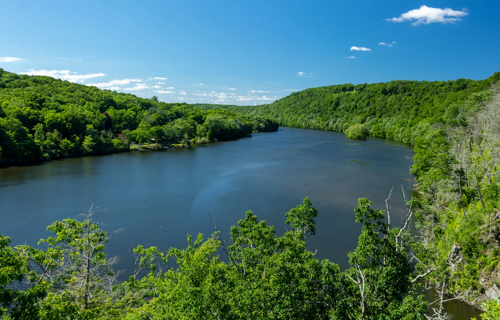
We crossed the bridge and got the first view of the Housatonic River. Taking a right off the bridge took us down a gravel road, also known as the Lovers Leap Trail. Within 0.3 miles of some incline, the money shot picture awaits. This scenic view offers the best one in the park overlooking Lake Lillinonah. From here, you could take your donut and go home, but there is some more hiking to be had at this park.
There are some interesting features and landmarks on some of the other trails. We decided to trace back our footsteps on the gravel road until we noticed the red markers for the Castle Trail on the right. Have a map handy, we had an issue finding. Pretty sure we did not go the way intended but it worked. The red blazed was a pretty good incline. Got my lungs working. Within a short distance, we came upon the castle ruin, which was just its foundation and a tall chimney. And, across from this was a castle-like turret. As I try to sit here explaining it, here’s a picture. If you must know more, I suggest the google machine.


In between the castle features, there is a trail we took that connects the red blazed trail to the blue blazed trail, known as the Falls Mountain Trail. We took a right from the red to the blue. This took us up a steeper hill.
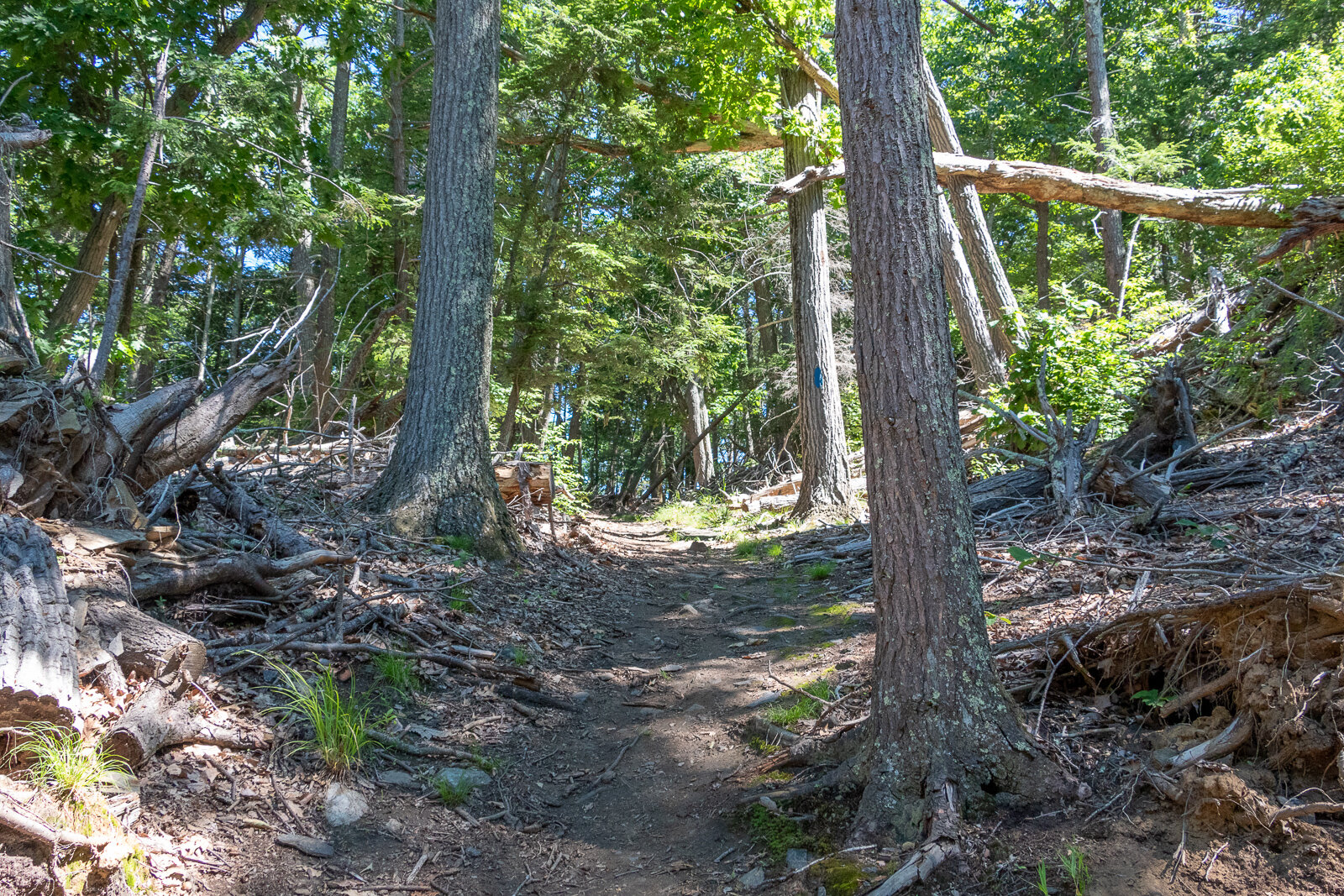
Once we reached the top of the hill, we saw a blue marker to the left but that was not correct. We met just bushes and the end of a ledge. It appears that it was painted incorrectly as a joke perhaps. That could be very dangerous if you are not paying attention. This is why we can’t have nice things. That person sucks who did that. Fortunately, we found other lost hikers and we noticed the view was behind us and we needed to retrace our steps and keep going straight and the ridge is on the right. From the ridge line, there is an open area view from the east that is pretty nice. From here, we retraced our steps down the blue to the red trail back to the gravel road.

Bonus Foodie Find:
After hiking, the post meal is important. Not all hikes are near donut shops unfortunately. However, other great food spots can be found. This hike is close to the downtown area of New Milford, CT. We stopped at Johana’s Restaurant for a brunchy meal. Great menu. I got the English Scramble - eggs, bacon, scallions, cheddar cheese in a skillet with home fries. Hell yes. And, my wife got the corn cheddar pancakes. That’s how we get down. Everything was delicious. Also, if you go in the warmer months, check out the farmers market. There’s an awesome bread company there.


HIKING FOR DONUTS
Hi, I’m Mark. I live in Connecticut. I take new trips every chance I get. A good trip has a great hike, great food, and something fun to do. My goal is to search out new trips and share them to inspire others to try something new and exciting.
If you are looking for posts in a particular place, search City or State here.
SEE OTHER POSTS IN ARCHIVE
Archive
RECOMMENDED POSTS


RECENT POSTS


See the latest on Instagram and follow @HIKINGFORDONUTS


Hidden Valley Preserve, Washington Depot, CT
Trail Description: The Bee Brook Loop is one of many trails in the Hidden Valley Preserve. This hike is an easy stroll along the Shepaug River. The Thoreau Bridge is the biggest attraction.
Trail Info:
Where: Washington Depot, CT Distance: 2.2m (1-1.5 hours) Difficulty: Easy Trail Type: Loop Features: Bridge, River, Water
How to get there:
198 Bee Brook Rd, Washington Depot, CT 06794
Parking lot can fit about 10-12 vehicles.
https://goo.gl/maps/Y1RQqqrmAjda6dcUA
Hiking Tips
Taking the fork to the right will bring you to the Thoreau Bridge within minutes.
There are other parking areas for different trails.
Trail map: Click Here!
The Hike
Apparently, the Washington, CT area is the mecca of public preserves in Connecticut. By mecca, I mean there’s three in a short distance of each other, which is pretty cool for nature buffs and hikers. Hidden Valley Preserve is one of three public preserves in the area owned by Steep Rock Association, along with Steep Rock Preserve and Macricostas Preserve. Hidden Valley Preserve offers 17 miles of trails consisting of various terrains and points of interest. The yellow blazed trail, known as Van Sinderen Loop Trail, will lead to the Quartz Mine and the “Lookout”, providing scenic views of the valley to the west. The Pinnacle Trail, blue blazed, also offers scenic valley views. The white blazed trail is the Bee Brook Loop, which is the quickest way to get to the Thoreau Bridge. That is the trail in this guide.
From the parking lot, there is a small footbridge that passes a small creek. This will lead to the start of the trail. There is a fork to choose your direction and we chose to go right following the White Trail for the Bee Brook Loop. Within minutes we arrived at the main attraction of the hike (for most), the Thoreau Bridge. This is a 134 foot suspension bridge hanging above the Shepaug River named in tribute to Henry David Thoreau. He was a philosopher, nature enthusiast, and advocate of hiking in the 1860s. Typically, this doesn’t do much for me nor do I get into details of history but the bridge contained many of his quotes along the railings that spoke to me.
The bridge was definitely the most busy part of this hike. It is a cool point of interest and really easy to get to. Now, I understand why it’s such a big instagram photo spot. From here, you can cross the bridge and continue onto another trail but we stayed on the White Trail hiking along the river.
Eventually, there is another wooden bridge that crosses the river on the right. This will connect you to the Yellow Trail if you want to jump on that. We just continued on the white blazed rail to finish the loop where we started. The hike was a pretty easy loop with some scenic river views. That was all I was looking for that day. Just a bit of time with nature.
HIKING FOR DONUTS
Hi, I’m Mark. I live in Connecticut. I take new trips every chance I get. A good trip has a great hike, great food, and something fun to do. My goal is to search out new trips and share them to inspire others to try something new and exciting.
If you are looking for posts in a particular place, search City or State here.
SEE OTHER POSTS IN ARCHIVE
Archive
RECOMMENDED POSTS


RECENT POSTS
See the latest on Instagram and follow @HIKINGFORDONUTS

Poets’ Walk Park, Red Hook, NY
Trail Description: Poets’ Walk Park is an easy jaunt through scenic meadows that offers wonderful views of the Hudson River and Catskills.
Trail Info:
Where: Red Hook, NY Distance: 2.4m (1.5 hours) Difficulty: Easy Trail Type: Loop Features: Views, Mountains, Water, River, Bridge
How to get there:
776 River Road, (County Road 103) Red Hook, NY
https://goo.gl/maps/y9V6GaXcWxRzqd6P9
Hiking Tips
Walk the entire loop. Many see the views of the bridge initially and turn around.
Not great phone service, so make sure to screenshot a map. Or my guide!
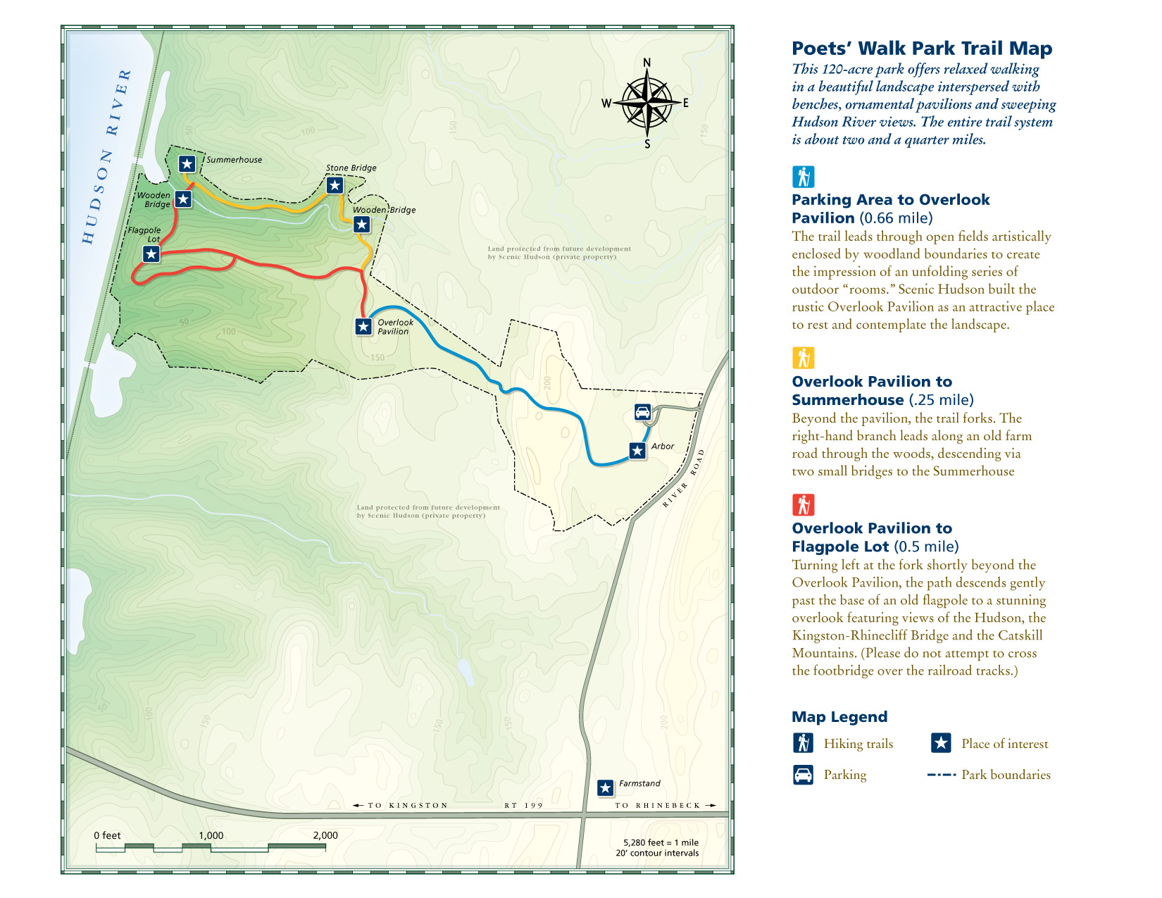
For trail map, click HERE.
The Hike
As I continue to look for the best bang for your buck views, I really don’t think it gets better than taking a stroll through Poets’ Walk Park in the fall. The Hudson Valley is full of amazing landscape and mountainous views. Most of those views require challenging hiking. However, a leisurely stroll in Poets’ Walk Park offers stunning views of the Catskills and the Kingston-Rhinecliff Bridge.
From the parking lot, begin walking on the gravel road by the trail signage. Continuing straight through the open field will lead you to a gazebo structure. Walking through the gazebo, there is the first “oh snap” view of the Kingston-Rhinecliff Bridge with the Catskills looming in the background. There is a neat little wooden bench to take a seat and enjoy the views.
The trail will split from here, where the loop begins. Either direction will bring you back to this spot. We chose left heading toward the river. Some great views of Catskills to the right and a closer view of the bridge to the left. The loop will begin on the right and suddenly you will find myself thwarted into the woods. There will be a few bridges to cross. If you need a moment of solitude, the Summerhouse gazebo area is a good spot to take a seat and look out into the mountains above the river.
From the Summerhouse structure, just retrace your steps back to the trail split and head on back to the parking lot. Easy peasy. The skies cleared on our the way back and the fall colors really popped. Just incredible views.
Depending on how long you choose to explore, take pictures, and enjoy the benches, this shouldn’t take more than an hour and half, give or take. Definitely one of those places I considered keeping to myself but the place was crazy packed. There is no secret here. It’s a spectacular park to visit for stunning views.
HIKING FOR DONUTS
Hi, I’m Mark. I live in Connecticut. I take new trips every chance I get. A good trip has a great hike, great food, and something fun to do. My goal is to search out new trips and share them to inspire others to try something new and exciting.
If you are looking for posts in a particular place, search City or State here.
SEE OTHER POSTS IN ARCHIVE
Archive
RECOMMENDED POSTS


RECENT POSTS
See the latest on Instagram and follow @HIKINGFORDONUTS

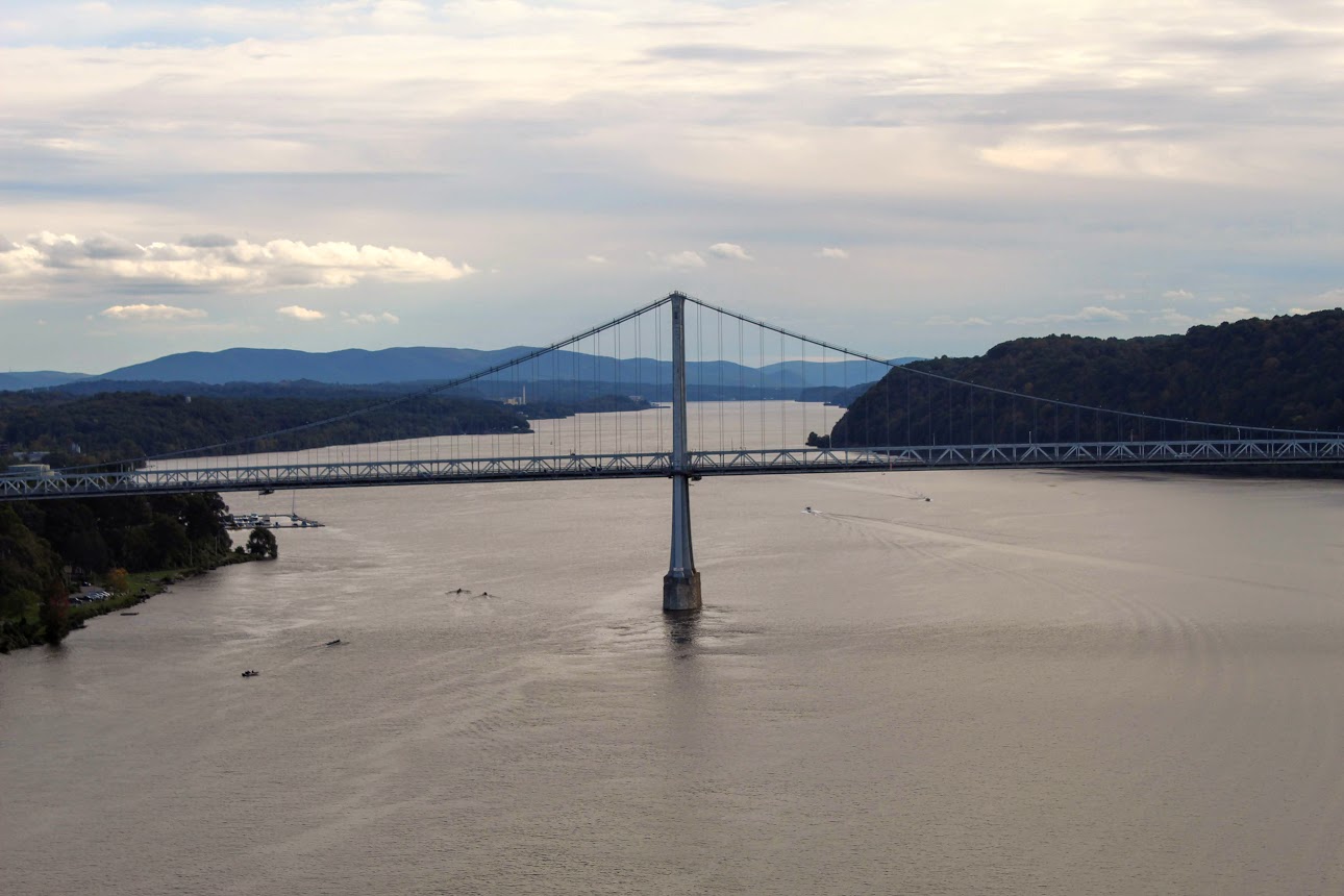
Walkway over the Hudson
Walkway Over the Hudson. What an amazing view! This isa bridge for walkers and runners and bikers only in the Hudson Valley in NY. A beautiful view of the Hudson River.
Trail Description: The Walkway Over the Hudson State Historic Park is the world’s longest elevated pedestrian walkway.
Trail Info:
Where: Walkway over the Hudson, Poughkeepsie, NY Distance: ~2.5m (1.5-2 hours) Difficulty: Easy Trail Type: Out and Back Features: Bridge, Hudson River, Views, Beach
How to get there: This is the address I used for the West entrance on the Highland side. Once you approach the area, you will see the parking.
87 Haviland Road
Highland, NY 12528
If you would like to park at the East entrance in Poughkeepsie, this is the address to enter:
61 Parker Ave
Poughkeepsie, NY 12601
This link is helpful also, https://walkway.org/visit/frequently-asked-questions/.
Hiking Tips:
The Highland side has more parking.
Can be very crowded. Plan accordingly.
The Hike:
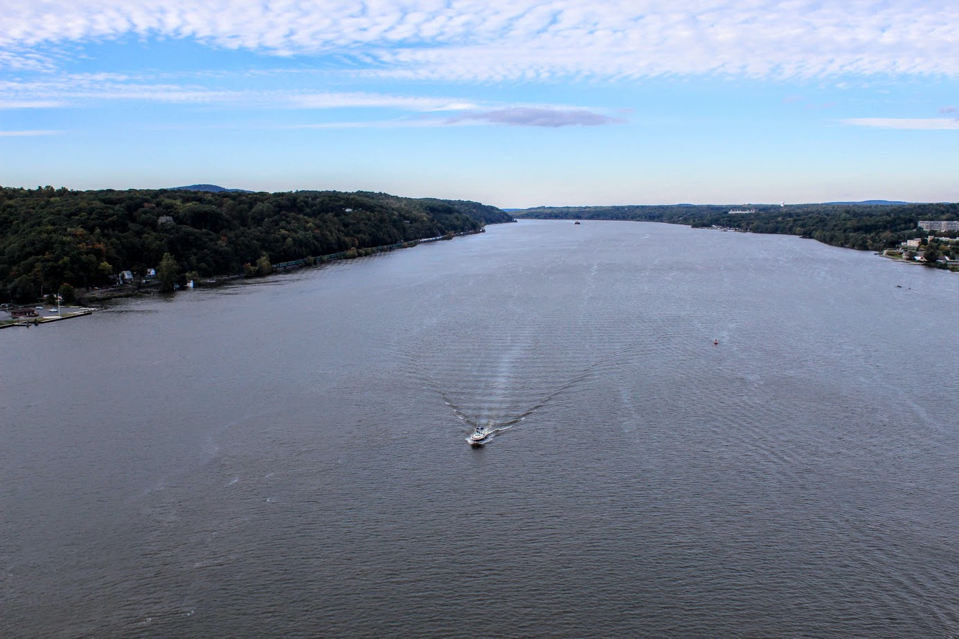
You know what they say, your girlfriend is always right. I can’t argue with that. While in upstate NY recently, Nichole suggested we would visit the Walkway Over the Hudson over a local hike. A simple walk over a bridge I say. Come on, I need stouter material for the blog. Some knowledge I was not aware of, the Walkway Over the Hudson State Historic Park is the world’s longest elevated pedestrian walkway. You read that right, in the whole entire world! The walkway extends 1.28 miles and hovers 212 feet over the Hudson River connecting Ulster and Dutchess counties in Poughkeepsie, NY. On this walkway you will see great views of Poughkeepsie, Mid-Hudson Bridge and Hudson Highlands. This has been open to the public only since 2009. I was skeptical but once I got there I was enthusiastic. I said to her, “Why haven’t we done this already?!? This is awesome!”
We decided to park on the Highland side as this tends to be easier to park with less of a crowd and ample parking. As I say about most outdoors activities in the Hudson Valley, prepare for a crowd. We went later in the day on a Sunday, so it wasn’t too bad. The NYC visitors probably needed to jump on a train to head back to the city.
As we made our way through the parking lot, we crossed train tracks and strolled through an open area where restrooms are located, multiple food trucks, and other vendors. A very cool spot to hang out before or after your walk.
Soon after we stepped on the bridge, I immediately saw the amazing views of why so many people visit this walkway. I saw the Mid-Hudson Bridge to my right and an open view of the Hudson to my left. The entire walk consisted of wonderful views. My head was on a swivel. For those curious about being on a bridge so high up, it feels very secure. The concrete makes this feel like just another sidewalk. Aside from the amazing landscapes views, this is definitely some great people watching material. You will see people walking dogs, baby strollers, running, power walking, bike riding, roller blading, you name it. And, lots of selfies. Beneath the bridge, you may see barges, boats, or some annoying person on a loud jet ski perusing the Hudson.
The walk can be as far as you like. You can stop anytime bridge and turn around to head back. We walked to the end of the bridge and back. If you live nearby, this is a great way to get exercise and enjoy the outdoors without too much demanding activity. Also, this is ADA compliant. There is an area to take an elevator up (closes certain times of the year). I would be a regular for sure. There are great pictures to be had here. Another successful exploration in the books and more lessons learned. Always listen to your girlfriend.


HIKING FOR DONUTS
A blog for the outdoors foodie enthusiast
Hi, I’m Mark. I live in Connecticut. I take new trips every chance I get. A good trip has a great hike, great food, and something fun to do. My goal is to search out new trips and share them to inspire others to try something new and exciting.
If you are looking for posts in a particular place, search by city or state here.
EXPLORE OTHER POSTS IN THE ARCHIVE
Archive
RECOMMENDED POSTS

MOST RECENT POSTS
SEE THE LATEST ON INSTAGRAM AND FOLLOW @HIKINGFORDONUTS