


South Mountain Loop Trail in Berlin, CT: Reservoir Views and a Hidden Ridgeline
South Mountain Trail, Berlin CT: Complete Hiking Guide
Hike the South Mountain Loop from Chamberlain Highway in Berlin, Connecticut, for views of Merimere Reservoir, Mine Island, East Peak, and downtown Meriden.
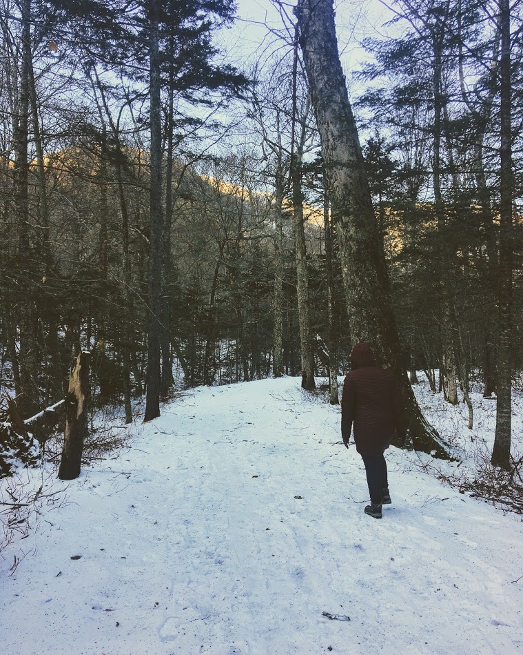
South Mountain is a hidden gem to me. I don’t see this mentioned too often online so exposing it I am conflicted. However, I also want my fellow hikers and followers to know this awesome hike resides in CT! With that said, hikers etiquette as always and leave not trace behind please. I would have never thought a hike like this existed off the side of a road. This trails begins aside Chamberlain Highway that initially feels more like a walk through the woods than a scenic mountain hike.
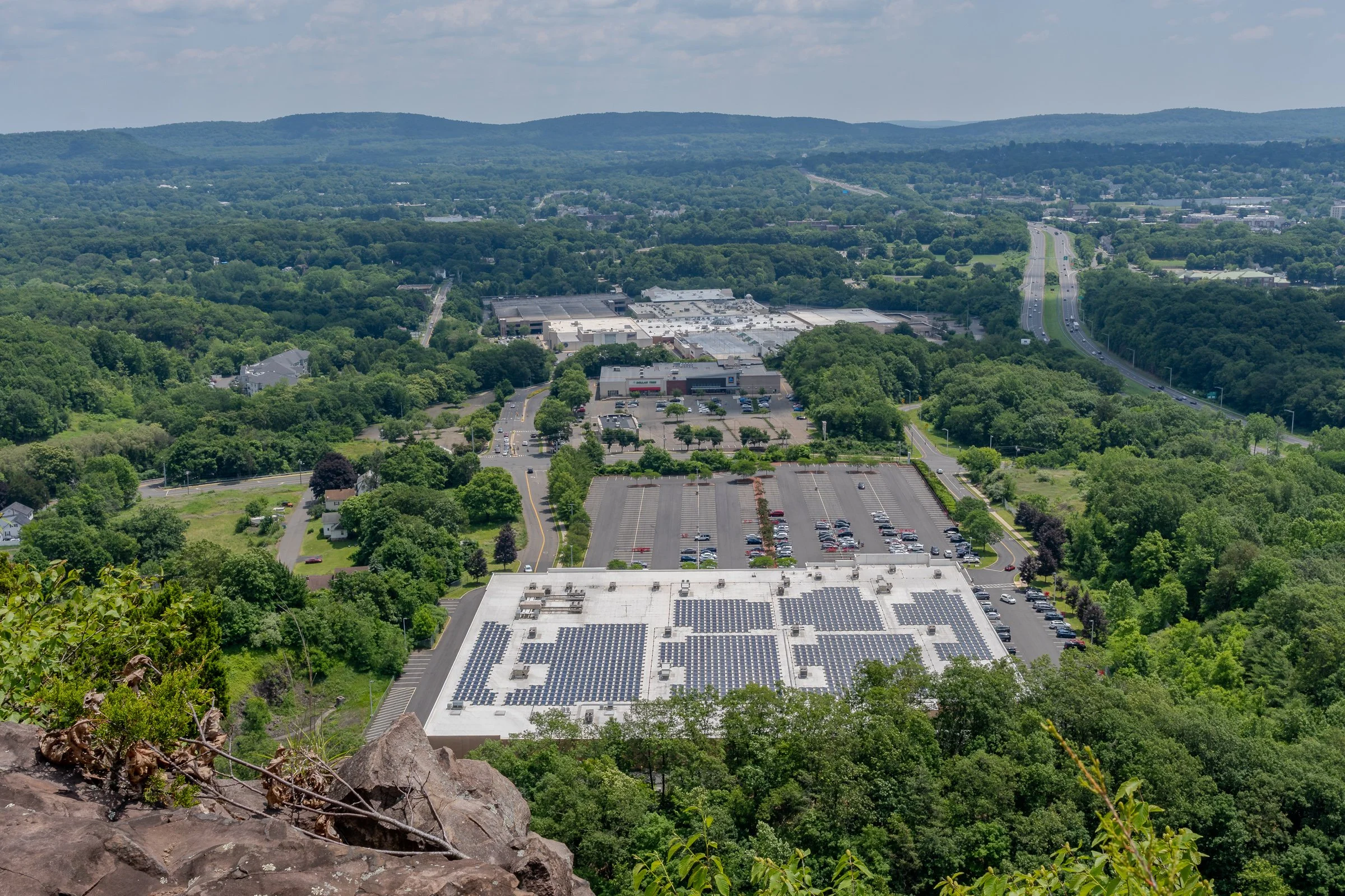
Once you reach the ridgeline, South Mountain delivers some seriously impressive views. The highlights include Merimere Reservoir, Mine Island, East Peak, Castle Craig, downtown Meriden, and the surrounding traprock hills.
This loop also feels much quieter than the more popular trails inside Hubbard Park. The parking area can be difficult to spot and parts of the route are poorly marked, but the views make the extra navigation effort worth it.
South Mountain connects with the blue-blazed Metacomet Trail, a 62-mile trail that follows Connecticut’s traprock ridges from the Hanging Hills north to the Massachusetts border. The Metacomet is also part of the larger New England National Scenic Trail.
Trail Description: The South Mountain Loop is a moderate hike that passes Elmere Reservoir before gradually climbing South Mountain. Several overlooks along the ridgeline provide views of Merimere Reservoir, Mine Island, East Peak, Castle Craig, downtown Meriden, and the commercial area near Interstate 691.
Trail Info:
Location: Berlin, CT (See link below)
Distance: Approximately 3.6 miles
Difficulty: Moderate
Trail Type: Loop
Highlights: Reservoir views, traprock cliffs, Mine Island, Castle Craig, and downtown Meriden
Dog Friendly: Yes
How to get there:
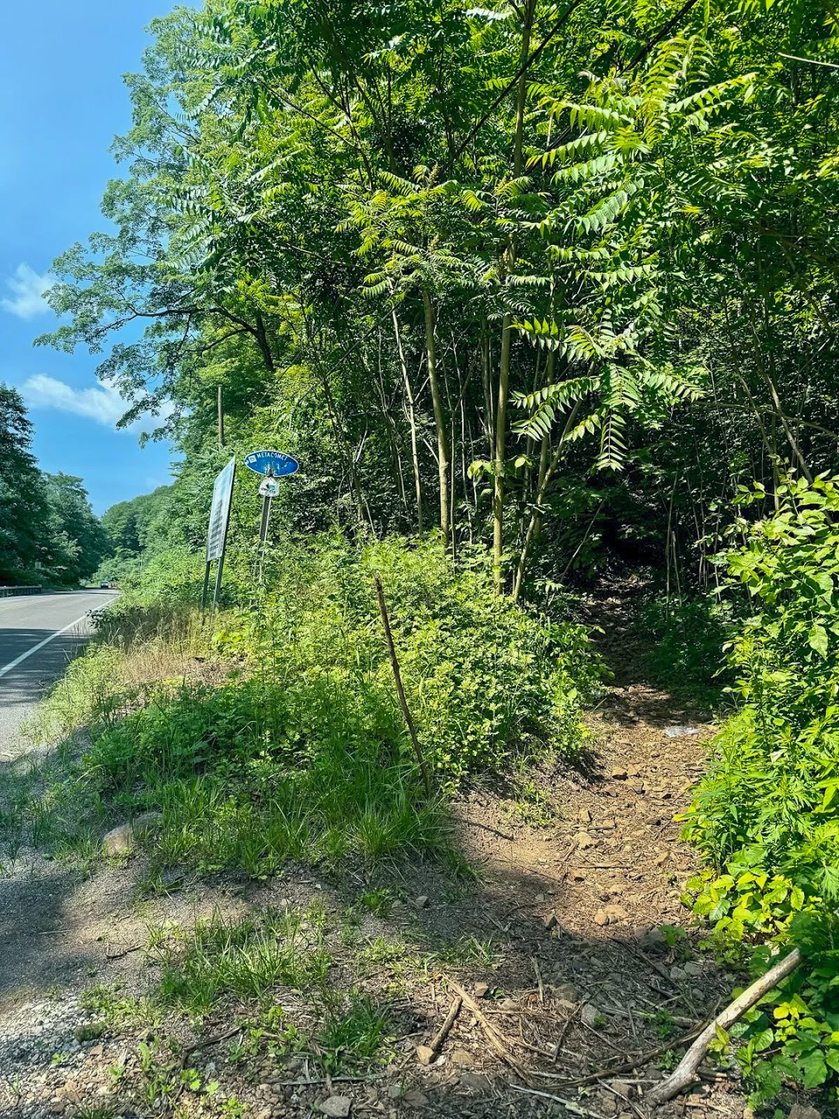
The trail begins where the blue-blazed Metacomet Trail crosses Chamberlain Highway, also known as Route 71, in Berlin.
Parking coordinates: 41.562803, -72.809665
This is not a traditional trailhead parking lot. There are only a few roadside spaces near the trail crossing, and the entrance can be easy to miss while driving along Route 71. Slow down as you approach and look for blue trail blazes on both sides of the road.
Do not block the roadway or park in the travel lane. When the closest spaces are occupied, additional roadside parking may be available a short distance south of the trail crossing.
Hiking Tips
Download park map, click here.
Parking is extremely limited, so an early start is a good idea on weekends.
Pay close attention at every major intersection. There are several unofficial or unblazed trails in the area, including routes toward Anderson Pond.
Nearby Things to Do:
Downtown Berlin for pre or post hike eats.
Donuts of course!
Post Hike Brews: Coles Roads Brewing

Panoramic Views
Parking Information
Drive slow as approaching this area as the parking area is small and can be missed.
South Mountain Trailhead
The Hike
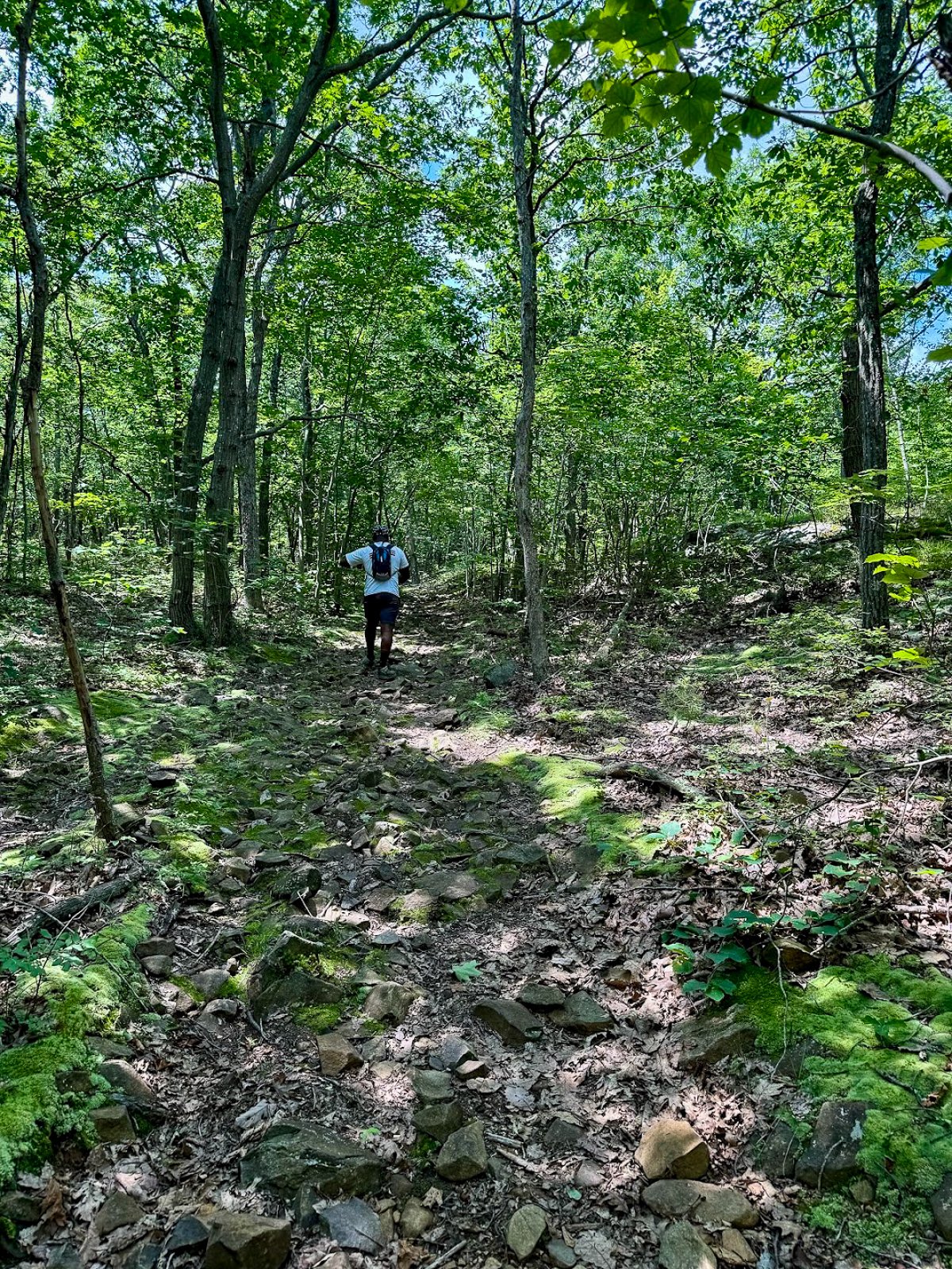
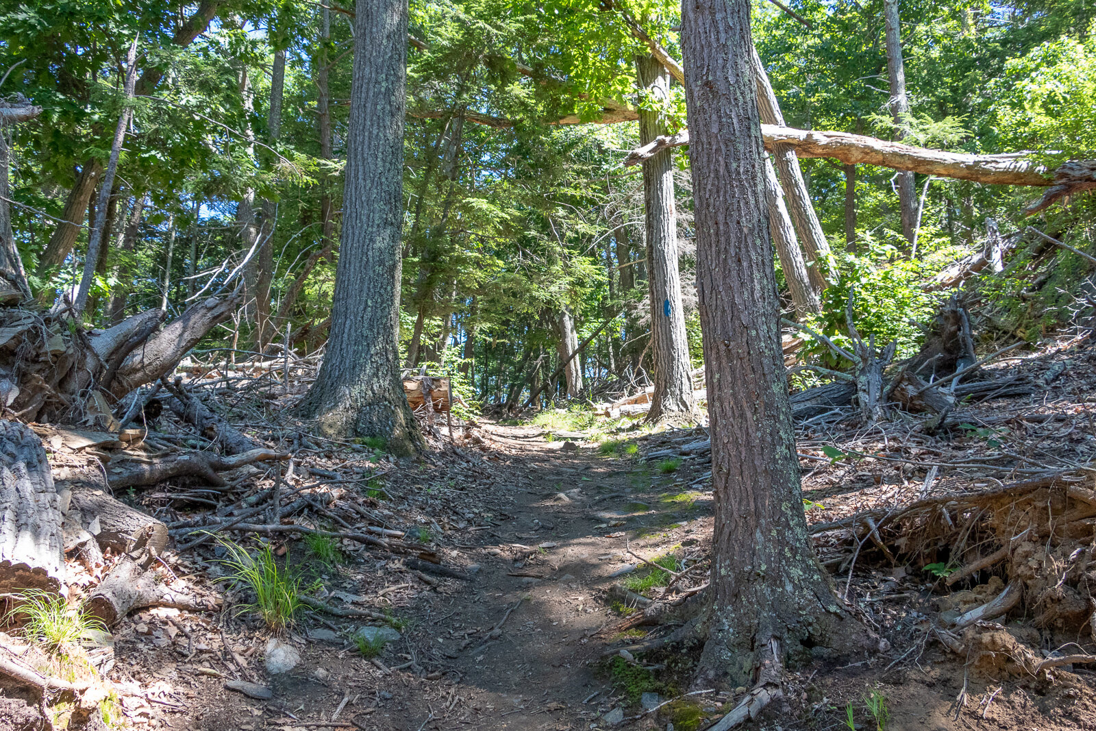
From Chamberlain Highway, enter the woods and begin following the blue blazes of the Metacomet Trail.
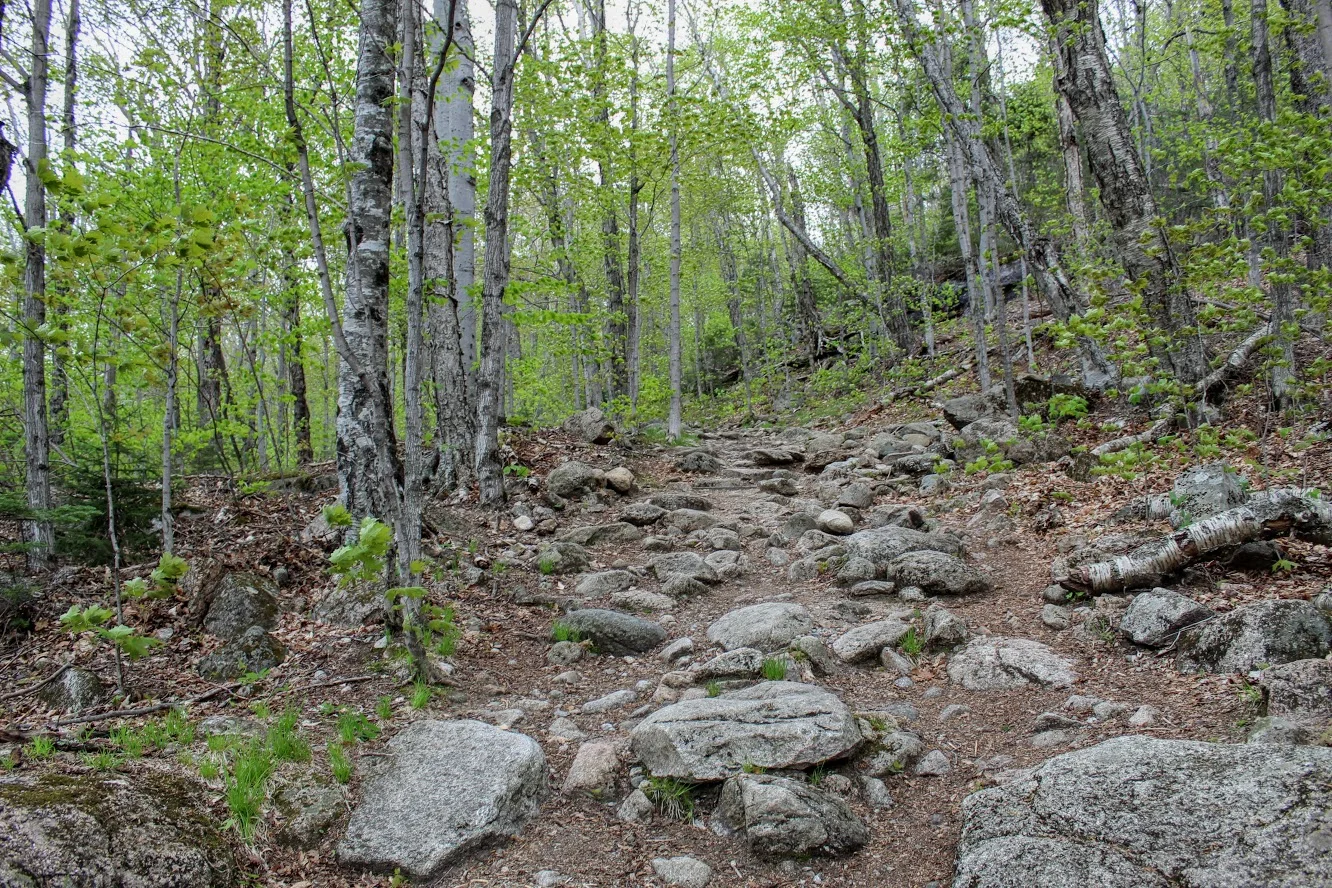
The opening section is relatively easy. You will soon pass a large water tank before arriving at Elmere Reservoir. It is not the dramatic mountain scenery you came for, but the reservoir provides a peaceful start to the hike.
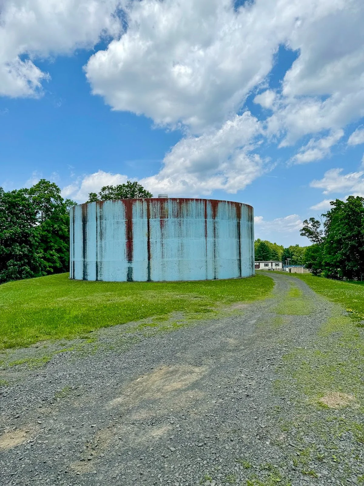
Water tank at start of hike
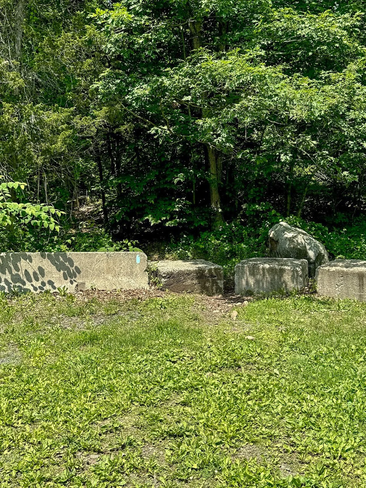
Continue beyond the reservoir and climb a small embankment near several concrete blocks. You will reach an intersection with an unblazed woods road. One direction leads toward Anderson Pond, while the other will eventually become your return route from the South Mountain cliffs.
For this route, remain on the blue-blazed trail.
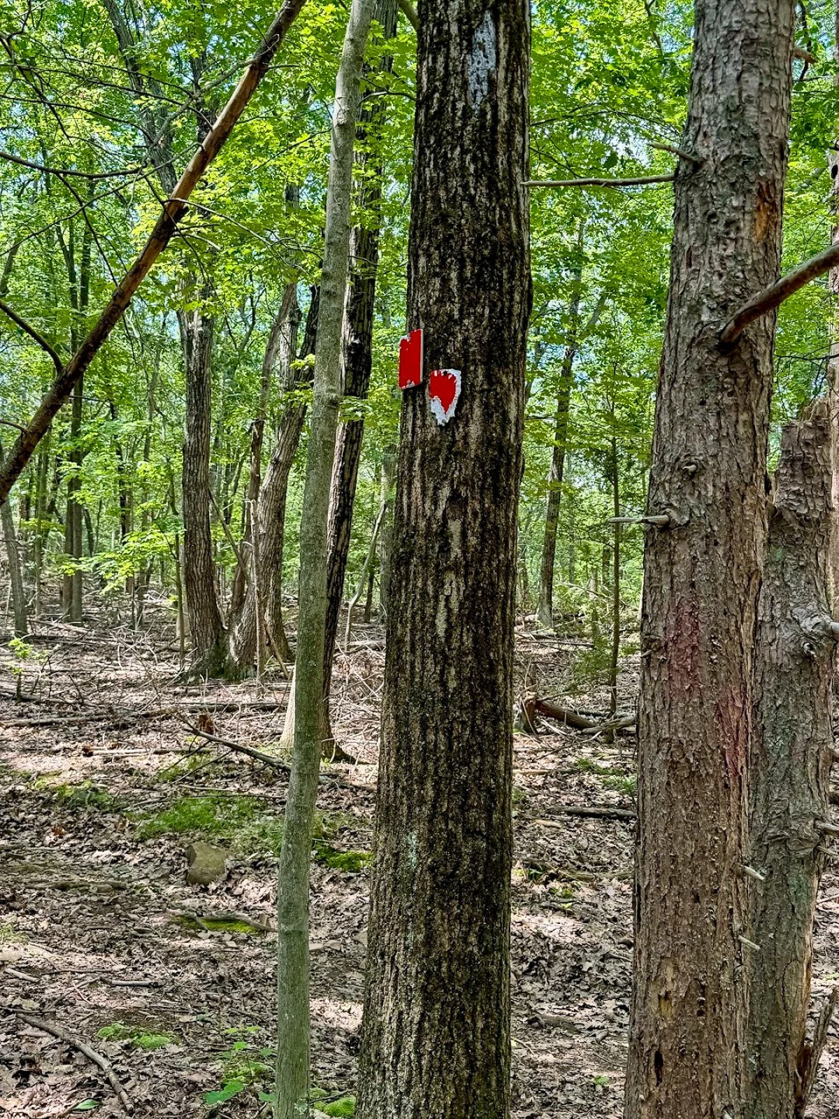
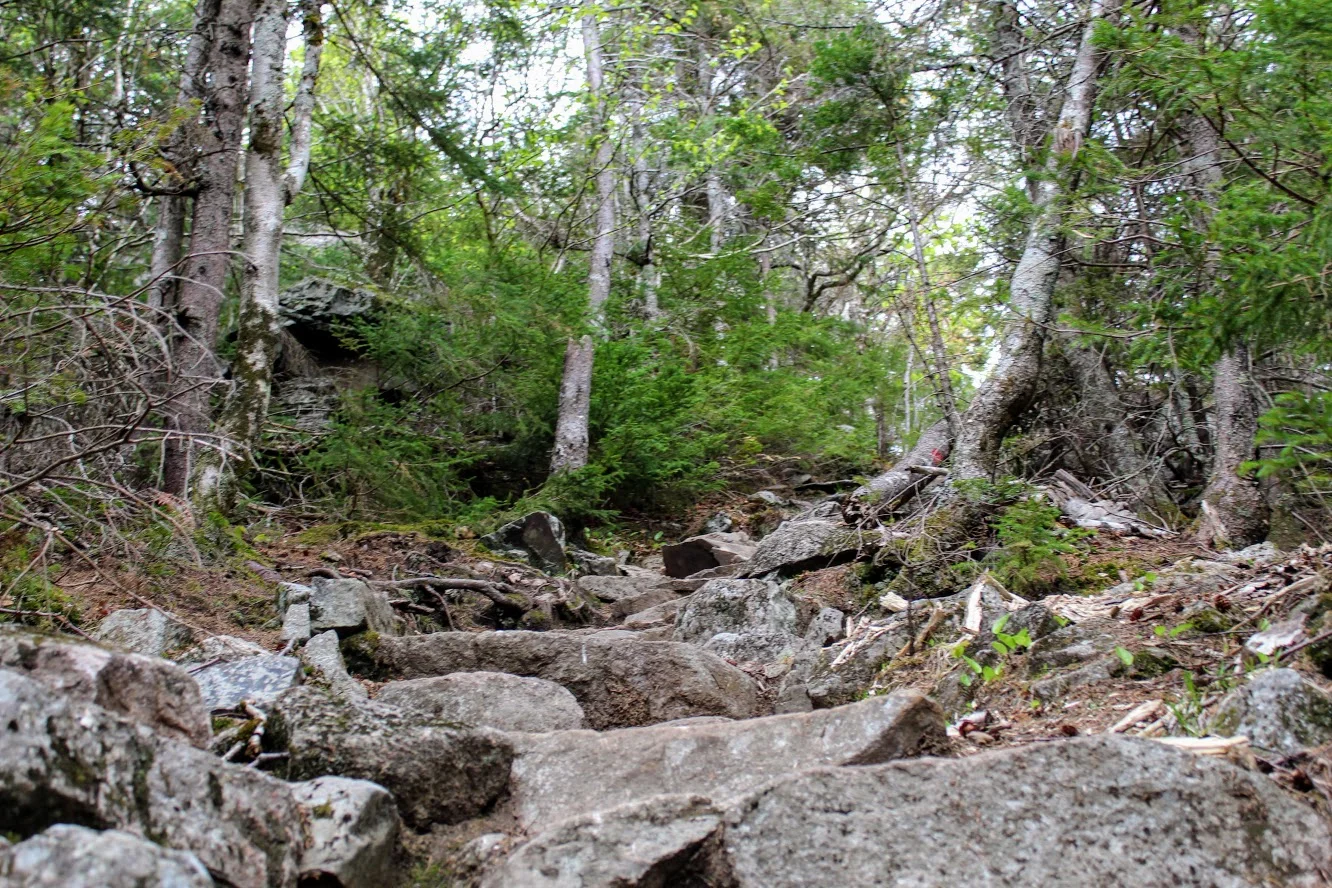
The trail may be rocky or wet through this section. Continue for a short distance until reaching another obvious intersection with a woods road on the left. Look carefully for faded or occasional red blazes.
Turn left here.
Climbing South Mountain
The red-blazed woods road begins a steady but manageable climb toward South Mountain. The incline is gradual rather than brutally steep, but it is enough to get the heart going.
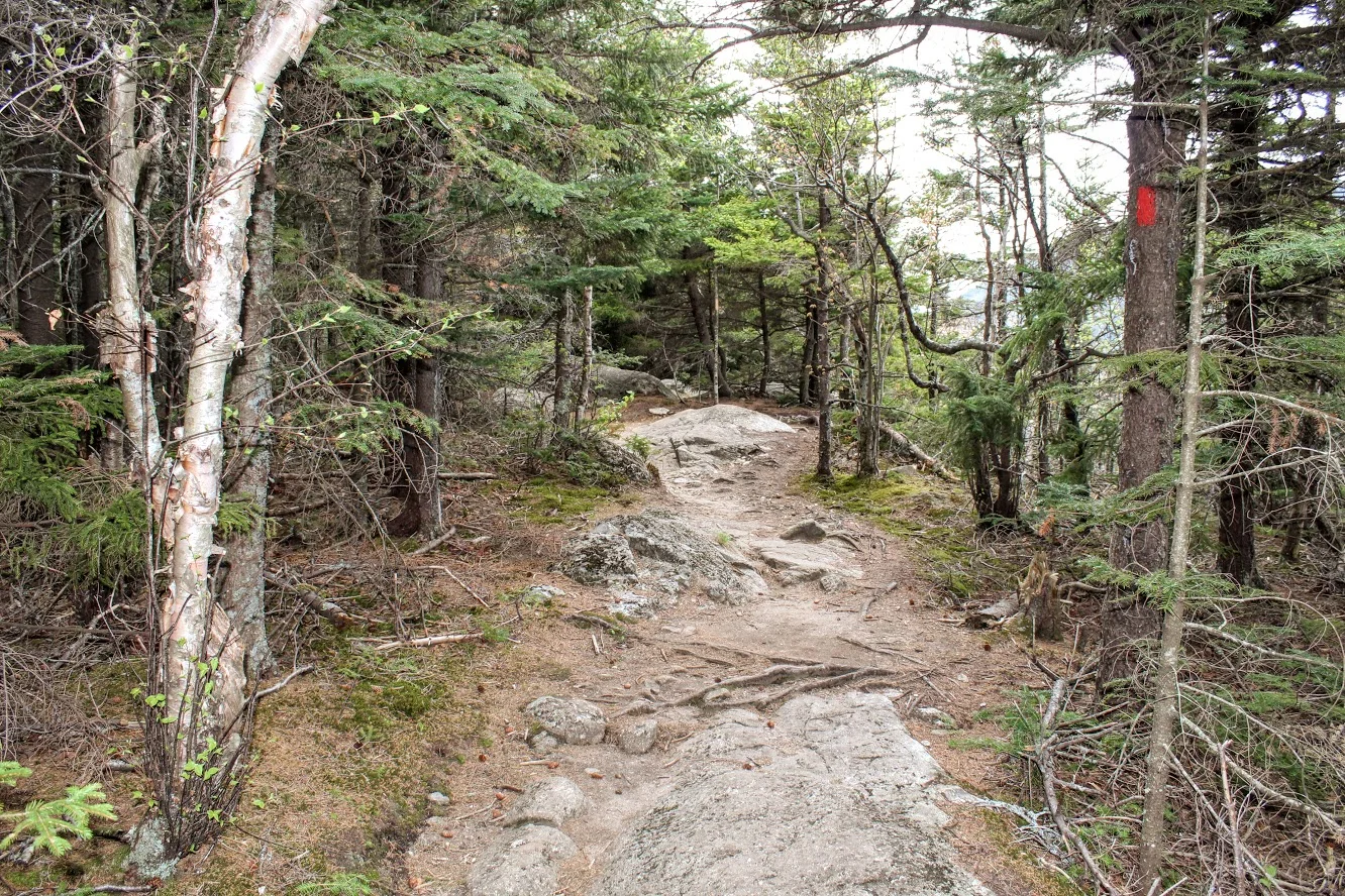
The trail markings become less reliable as you gain elevation. Stay on the most established woods road and check your map whenever you reach a questionable intersection.
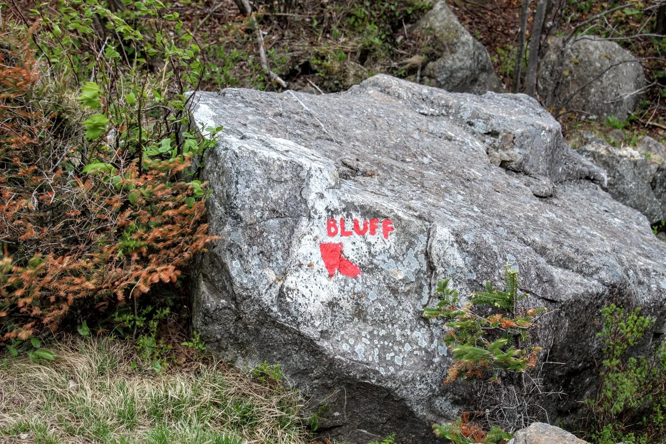
As you approach the top, watch for a poorly marked side trail on the right. This short path leads to one of the best viewpoints on the entire hike.
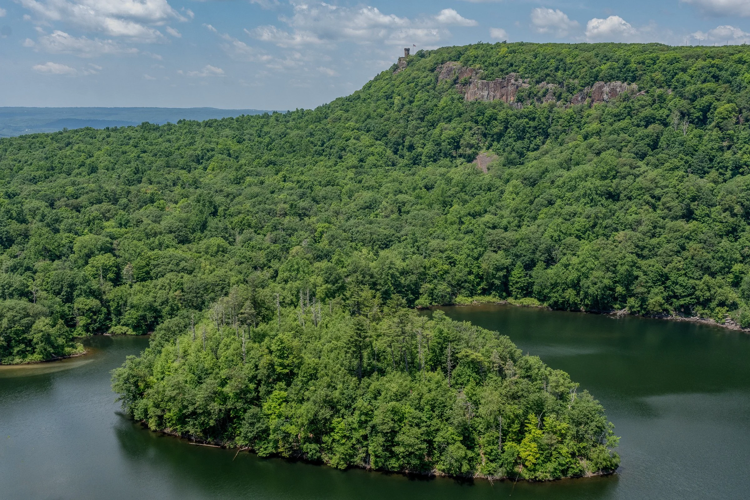
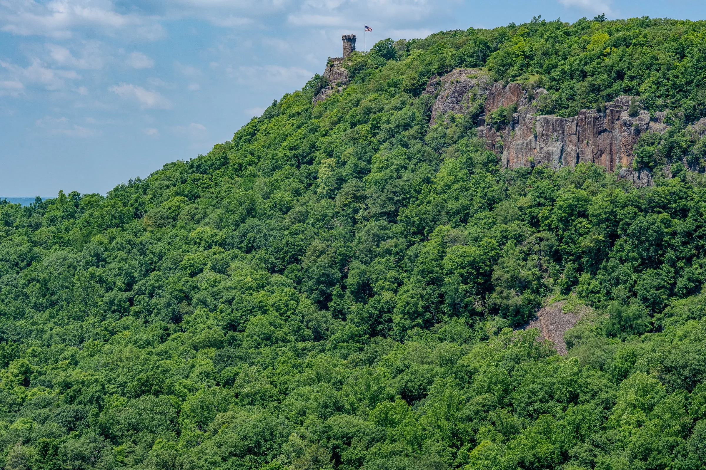
Merimere Reservoir Overlook
The first major overlook provides a gorgeous view across Merimere Reservoir.
Mine Island sits prominently in the water, with East Peak rising behind it. Castle Craig may also be visible along the ridgeline. This is the money-shot view of the hike and a great place to stop, catch your breath, and take a ridiculous number of pictures.
The open ridgeline provides a wide view across the reservoir and surrounding Hanging Hills. It feels like a much bigger mountain experience than you might expect from central Connecticut.
South Mountain rises to approximately 767 feet, while the reservoir and surrounding valleys sit several hundred feet below the cliffs.
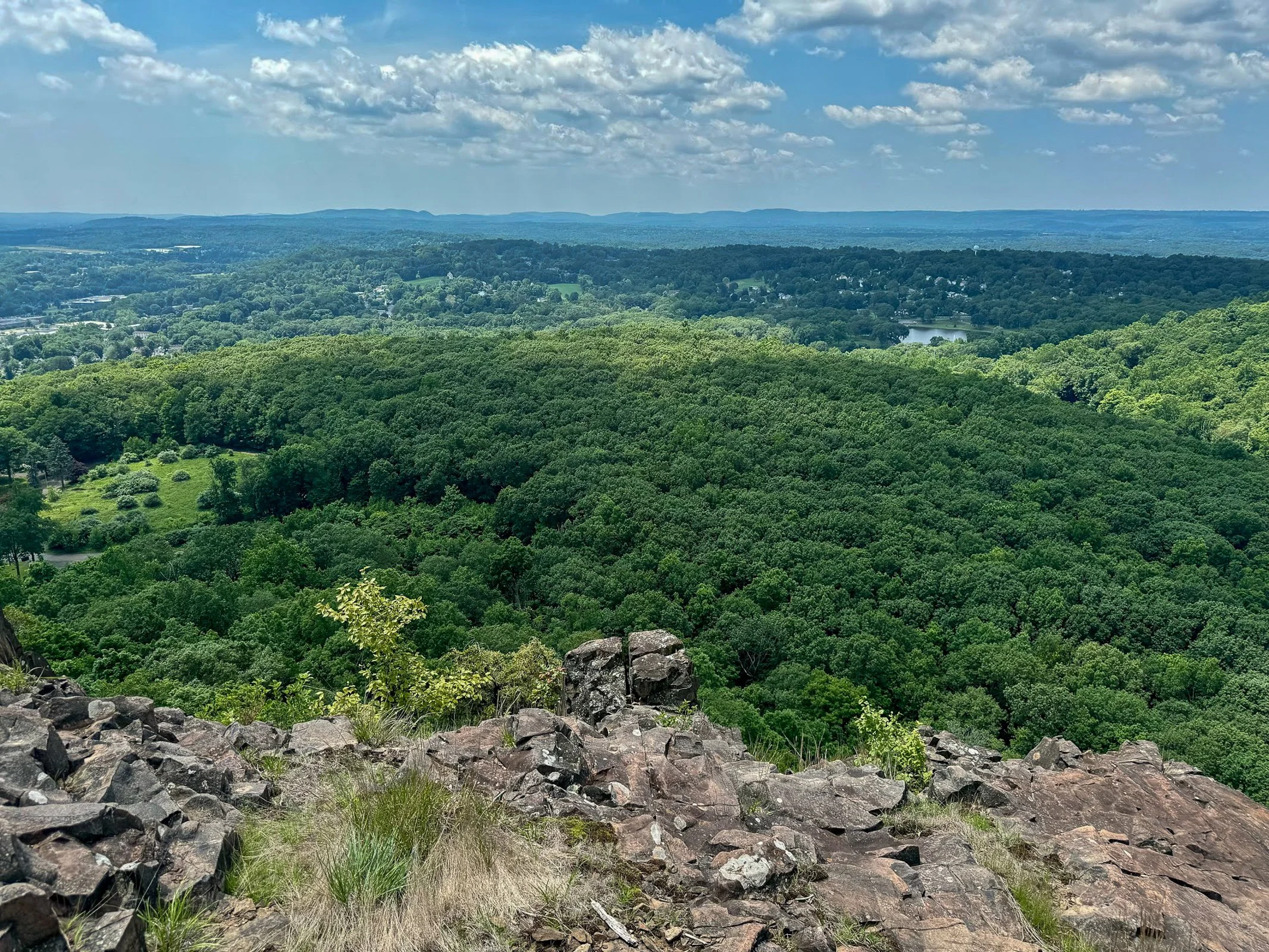
Downtown Meriden Overlook
After taking in the reservoir views, return to the main loop trail and continue along the ridge.
The woods road dips and climbs gently before reaching another open viewpoint. This side of South Mountain provides a dramatic look toward downtown Meriden and the developed areas surrounding Hubbard Park.
The contrast is interesting. One minute you are looking across a quiet reservoir toward Castle Craig, and the next you are standing above the city.
Continue following the ridgeline through the open woods. Trail markings may still be inconsistent, but the main route is usually easy enough to identify.
Target View and the Return Route
As the trail curves around the mountain, you will reach the east-facing cliffs sometimes referred to as the Target View. The shopping area sits directly below, with Interstate 691 and several additional traprock ridges visible in the distance.
It may not be the classic wilderness view, but it shows just how suddenly South Mountain rises above the surrounding city.
Continue descending on the woods road. This portion completes the loop and eventually returns to the earlier intersection near Elmere Reservoir.
Once you reconnect with the blue-blazed Metacomet Trail, turn right and retrace the opening section of the hike. Pass Elmere Reservoir and the water tank before returning to Chamberlain Highway.
Nearby Things to Do
It would not be Hiking for Donuts without a post-hike treat. Swiches & Coffee Donuts is a good option in town. After this hike, me and my buddy went to the local brewery, Coles Road Brewing. Also, Kensington Pizza is a big spot locally. Downtown Berlin has been getting new restaurants so be sure to stop in town.
Neil’s Donuts in Wallingford is a solid option as well after exploring South Mountain. It is not too far away for some amazing donuts.
Other Connecticut Hikes Nearby
Looking for more scenic Connecticut hikes?
Follow Hiking For Donuts on Instagram for more New England hiking adventures.

HIKING FOR DONUTS
Hi, I’m Mark. I live in Connecticut. I take new trips every chance I get. A good trip has a great hike, great food, and something fun to do. My goal is to search out new trips and share them to inspire others to try something new and exciting.
If you are looking for posts in a particular place, search City or State here.
SEE OTHER POSTS IN ARCHIVE
Archive
RECOMMENDED POSTS


RECENT POSTS


See the latest on Instagram and follow @HIKINGFORDONUTS

Haystack Mountain Trail, Connecticut: Fire Tower Hike With Epic Views
Haystack Mountain State Park Trail Guide (Norfolk, CT)
Haystack Mountain State Park might be one of Connecticut's best "bang for your buck" hikes. Less than a mile round trip gets you to a stone fire tower with sweeping views across four states.
Haystack Mountain State Park in Norfolk, Connecticut is one of the best short hikes in New England. This quick out-and-back trail leads to a historic stone fire tower with sweeping 360-degree views into Connecticut, Massachusetts, New York, and Vermont.
At less than a mile round trip from the upper parking area, this is an excellent beginner-friendly hike with a huge scenic payoff. If you’re looking for an easy Connecticut hike with mountain views, this trail deserves a spot on your list.
Trail Description: Haystack Mountain Trail contains an impressive stone fire tower with stunning views of the mountains in Connecticut, Massachusetts, New York, and Vermont.
Trail Info:
Location: Norfolk, CT (See link below)
Distance: 0.8 mile (30-45 min) Round Trip
Difficulty: Moderate
Trail Type: Out and Back
Highlights: Views, Mountains, Valley, Fire Tower, Panoramic Views
Dog Friendly: Yes
How to get there:
Haystack Mountain State Park - On Rte. 272 Norfolk, CT 06058
Trailhead parking location here.
Easy to find off Route 272. The road goes halfway up Haystack Mountain to a parking lot, where the shortest trail starts. The parking lot can hold about 10 cars.
Hiking Tips
Download park map, click here.
Cell phone service is spotty. Hike carefully.
There can be seasonal closures of the park.
Nearby Things to Do:
Yellow Trail: Longer 1.8 Mile Hike (starts at the beginning of park road at the gate entrance)
Nearby Hikes: Litchfield County area has some great short hikes you could pair with this one.
Post Hike Brews: NorBrook Farm Local Brewery

Panoramic Views
Haystack Mountain Trail Guide
Haystack Mountain State Park in Norfolk, Connecticut is one of the best short hikes in New England.
At less than a mile round trip from the upper parking area, this is an excellent beginner-friendly hike with a huge scenic payoff. If you’re looking for an easy Connecticut hike with mountain views, this trail deserves a spot on your list.
This guide will be for the shortest trail route at 0.8 miles from the top parking lot of Haystack Mountain. These days my time is a bit limited and the best bang for your buck is what is more appealing. If you want to make it a longer hike, there is the Yellow Trail that starts near the beginning of park road at the gate entrance. This will be 1.8 miles, out and back. Both of these options will be great hikes to get to the main attraction, the amazing tower views.
Trail Overview

Haystack Mountain Trailhead
Parking Information
Once you have parked at the top parking, which is about a mile once you enter the park, the trail is to the left to begin the summit.

Haystack Mountain Trail
The Hike to the Fire Tower
This trail is fairly straightforward. It is well-maintained and clearly marked. The first 0.2 miles are flat and easy breezy. The next 0.2 miles will get your heart pumping as the trail bends to the left and starts a quick incline with 200 feet of elevation. Those quads might be on fire but it is all worth it once you see the bad ass tower at the top.
Check out my Instagram reel for a video walkthrough of the Haystack Mountain Trail and the fire tower views here.

Haystack Mountain Trail Incline
Now, it’s time to climb the 34 foot stone tower up to the top for the 360 views at 1,683 feet of elevation.
Tower Views and What You’ll See

Haystack Mountain Fire Tower
Definitely some of the best views you will have in Connecticut. It was a bit overcast and cloudy for me, but still impressive views nonetheless. On a clear day, there is visibility of the Riga Plateau in Northwest Connecticut, the Berkshires in Massachusetts, the Catskills in New York, and the Green Mountains of Vermont. That is quite a combination of views.

View at the Top

Haystack Mountain Trail Views

Nearby Breweries and Things to Do
This would be great to pair with some other short hikes in the Litchfield County area. In addition, there are great local breweries as well such as NorBrook Farm for post hike brews.
Things to Do Nearby:
Yellow Trail: Longer 1.8 Mile Hike (starts at the beginning of park road at the gate entrance)
Nearby Hikes: Litchfield County area has some great short hikes you could pair with this one.
Post Hike Brews: NorBrook Farm Local Brewery
Other Connecticut Hikes Nearby
Looking for more scenic Connecticut hikes? Check out these links to other trail guides for hikes in Litchfield County:
Follow Hiking For Donuts on Instagram for more New England hiking adventures.
HIKING FOR DONUTS
Hi, I’m Mark. I live in Connecticut. I take new trips every chance I get. A good trip has a great hike, great food, and something fun to do. My goal is to search out new trips and share them to inspire others to try something new and exciting.
If you are looking for posts in a particular place, search City or State here.
SEE OTHER POSTS IN ARCHIVE
Archive
RECOMMENDED POSTS
RECENT POSTS
See the latest on Instagram and follow @HIKINGFORDONUTS

Hiking Mount Agamenticus, York, Maine
Trail Description: The Mount Agamenticus Conservation Region is located in Southern Maine. The Mount Agamenticus Loop is a popular trail that provides 360 degree views at the summit of the surrounding mountains in the distance.
Trail Info:
Where: York, ME Distance: 1.8m (1 hour) Difficulty: Easy toModerate Trail Type: Loop Features: Views, Mountains, Valley
How to get there:
Typing the location “Mount Agamenticus Trailhead” into Google Maps will take you to the parking lot. You can’t miss it. There is a lot of parking. It’s $2/hr to park and there is a barcode to scan for the app to use to pay. It was easy peasy in my opinion. And, worth the money based on how well they keep up with everything.
Coordinates: 43.21720438450835, -70.69198787482621
Link to google maps location here.
Hiking Tips
I suggest caution if it rained days prior. The trails in the forest are mostly roots and rock. Dry it’s no biggie but wet I don’t think it would be as enjoyable.
Download a copy of the trail map here.
There are multiple trail options. This guide is for the loop via Blueberry Bluff, Witch Hazel, and Ring Trail. The Big A trail has separate parking and is a 1 mile loop that’s mostly gravel & an easier option (stroller and wheelchair friendly).
The trail and parking lots are well maintained and great facilities. Nicest outhouse bathrooms I ever been in!

The Hike
Once parked at the Mountain Road parking lot, the beginning of the trail head is visible with markers at end of the parking lot.

There will be trail signs promptly upon starting the hike at a fork. Stay right and hop on the Ring Trail, which is the white marked trail.

As stated prior, the trail is very well marked. However, the trail is mostly rocks and roots. I saw some reviews mentioning that it was muddy and unpleasant after a rainstorm. And, I totally understand what they meant. The rocks and roots could be slippery. For us, it was dry and there were no issues.

There isn’t much of an elevation gain, only about 340 feet. But there is a small incline as you make your way to the top. Hiking along the Ring Trail, at almost 0.7m, there will be a small foot bridge with a path to the left at the end. This is the Witch Hazel trail. I did not see signs but based on the trail map, this was the way to go.

The Witch Hazel trail is brief. Only a few minutes to reach the Big A Trail. There will also be a small foot bridge.

And following the Big A trail at the top is where the first lookout platform is to take in all the views.

There is another lookout platform with stairs where you can see even higher out into the valley. There is also a fire tower, but it is fenced out and cannot be climbed.


Follow the Big A Trail out until it connects to the Blueberry Bluff, which is marked red. There is also an additional viewpoint here before the Blueberry Bluff.

Continue down the Blueberry Bluff back to the Ring Trail. Take a left at the sign back to the parking lot. You will cross the road at the end to get back to your car.

Southern Maine is tracking to be one of our favorite areas to visit and this was a great first hike in the area. Good hike to get the heart going and see some cool views. The platforms are a cool feature for viewing on the summit. And, the trails and parking lots are so well maintained. I cannot speak highly enough on that. I was not able to find a great guide with details for this hike so I am hopeful this will be helpful for others. It’s also good to see directions/steps before you go to get comfortability. Not a hard hike to follow but I understand where folks can get tripped up. I still do it many times. Luckily, my wife is always the voice of direction.
POST HIKE ACTIVITIES: The fun doesn’t have to stop here. Lots to do in the area. We stopped by the 90s themed brewery, Odd by Nature Brewing, for some post hike beers and nosh, which is about 8 minutes from the trailhead. And, the Nubble Lighthouse is roughly 15 minutes or so away. Definitely a trip to view. Cape Neddick is really cool. Many restaurants in the area as well. No matter what you decide to do, there is a lot to plan for a great weekend or day trip.

HIKING FOR DONUTS
Hi, I’m Mark. I live in Connecticut. I take new trips every chance I get. A good trip has a great hike, great food, and something fun to do. My goal is to search out new trips and share them to inspire others to try something new and exciting.
If you are looking for posts in a particular place, search City or State here.
SEE OTHER POSTS IN ARCHIVE
Archive
RECOMMENDED POSTS


RECENT POSTS
See the latest on Instagram and follow @HIKINGFORDONUTS

Zion National Park Travel Guide - Plan Your Trip
Located in Southern Utah, Zion National Park is one of the most popular National Parks. It has been in the top 3 most visited parks in the US over the past few years and I do not see that changing. Zion is a smaller national park but packs a punch with numerous thrilling hikes and breathtaking views. Lots of easy to moderate day hikes mixed in with some overnight backpacking adventures. Zion is home to many iconic trails such as the Narrows and Angel’s Landing. You don’t even have to hike to see Zion’s beauty. Just driving through the park is amazing. There is really a lot to do in Zion and there is something for all park visitors.
However, like most National Parks, it takes a lot of planning and research to maximize your trip and enjoy all the park has to offer in the allotted time available. There’s a shuttle bus to consider, weather, river flow rates, permits and reservations. In this guide, I hope to provide you with all the best information to have an incredible trip in Zion National Park.
About Zion National Park
Zion National Park is located in Southern Utah with the closest airport approximately 2.5 hours away in Las Vegas. And, the next closest is 4.5 hours away in Salt Lake City. You can either do this as a standalone trip and or make it a road trip for more Utah national parks. My trip included Zion, Bryce Canyon, and Capital Reef from Las Vegas. You will need to rent a car from whichever airport you choose.
Travel Tip: Zion has limited parking. If you have an oversized vehicle, most parking lots are not accommodating. Parking in Springdale and hopping on their free shuttle or Zion Canyon Visitor Center would be my suggestion.
Zion National Park shuttle
The Zion Canyon Shuttle is in operation most of the year, typically mid-February/March to November. During the time frame, cars are not permitted to drive in the Park along the Zion Canyon Scenic Drive. Fortunately, the shuttle operated by the Park Service is free, fast, and easy. You do not need to reserve shuttle tickets. The shuttle drops off at all major trailheads in the park and operates 7 days a week beginning mid-March. For more info on the full schedule and hours of operation, check out Zion's website, https://www.nps.gov/zion/planyourvisit/zion-canyon-shuttle-system.htm.
The Park shuttle departs from the Visitors Center in short intervals. Just hop on and get off at your convenience. Make sure you know the correct shuttle stop for your hike. Lines start building up rather quickly mid-morning to board the shuttle. Sometimes over an hour wait during peak season and holiday weekends.
Travel Tip: Try to get in the shuttle line by 8-9am to avoid long waits for the shuttle, especially if you are doing the Narrows or Angels Landing hikes. Also, make sure to check when the last shuttle time for that before you hike. Shuttle start and end times vary depending on the season. Don’t miss the last shuttle. Or else it is another 4 mile walk to the Zion Lodge and then you need to figure out how to get back to the Visitor Center!
If there is no parking at the Visitors Center, there is a second shuttle system in town, the Springdale Shuttle. This connects the hotels in Springdale with the main entrance of Zion in the case there is no parking.
When to Visit Zion National Park
The best time to visit Zion National Park is in the Spring and Fall. The park’s mild weather is best for hiking. And, the crowds are not as bad. April/May and September/October would be ideal. Both times I went were in mid to late May, where the weather was great and crowds feasible for most of the park.
Summer is the peak visitation of the park where crowds can be excessive. Popular hikes can be unpleasant due to the amount of people on the trail. Also, temperatures can often reach over 100 degrees.
Zion National Park is open all year-round, which allows you to hike in the off-season. The park doesn’t see heavy snow in the winter, but it is not ideal conditions to hike the park due to some trails being icy and requiring traction equipment.
With that said, everyone goes to hike the Narrows. This requires more thought. The trail is typically closed in the March to May timeframe when water levels are high. The weather is cooler and the water is much colder. Same conditions apply for the fall. With that said, my last visit was in the middle of May with air temperatures mostly in the mid to high 80s. The water was cold, about 45-50 degrees,but it was not bad at all since the air temperature was so high. No issues with water levels but always check the weather and prepare to rearrange your trip if needed. Summer is a great time to hike the Narrows because the weather is excellent with high temperatures. The days are longer, shuttles run all the way to 9pm, and the water in the river is at its warmest. However, the monsoon season creates the highest risk of flash floods during this time. This can be done in the Winter but the temperatures, air & water, are much colder. The shuttle bus does not run often, only on certain days. And, snowfall can potentially close the trail.

Best Things to do in Zion National Park
Hike the Narrows
The Narrows leads you through Zion Canyon and the Virgin River with twists and turns through the stunning slot canyon less than 20 feet wide in some areas stretching 15 miles. The “trail” is one of the most popular in the park. There are 2 ways to do this hike, bottom up or top down. Bottom up starts at the Riverside Walk at the Temple of Sinawava trailhead. The hike will continue upstream and the farthest you can go without a permit is Big Springs. This is the route most hikers take. However, for a more adventurous thrill, you can hike the full Narrows top down and a permit will be required. This journey will be 16 miles long and could span over 2 days.
Travel Tip: Catch the Zion Shuttle early. Make sure you watch the weather and bring proper gear for this hike. Do your research!
For more detailed info, including the trail, equipment and more helpful tips, check out my full guide on hiking the Narrows, click here.

Hike Angels Landing
Angels Landing is the most popular hike in the park. Thousands of visitors each year, mostly in the summer, seek out this hike. The trailhead is The Grotto (stop #6 on the Zion Shuttle). This hike is strenuous coming at about 5.4 miles round trip. The elevation gain is 1500 feet. The popularity of the trail due to not only the picturesque view but the thrilling journey to the top. The hike consists of chain-assisted rock scrambling sections and uphill switchbacks. With the final climb scaling a narrow ridge high above the valley floor. This is not for the faint of heart. If you have a fear of heights, this one may not be for you. At the time of my visit, there were no permits and the trail was pretty packed where people were literally on top of each other so I chose to skip. I did not feel comfortable or compelled enough to attempt the\is hike with hikers on my heels the entire time. Since that time, permits are now required via a lottery system. Both seasonally and the day before your planned hike. It costs $6 to enter an application and if you are one of the lottery winners, you will pay $3 per person.
Hike to Observation Point
For some of the best views in the park, the entire hike to Observation Point is stunning. However, the hike is extremely challenging at 8 miles long and 2300 feet of climbing. The climb is steady until the final viewpoint. The trailhead is Weeping Rock (stop #7 on the Zion Shuttle).
More Hiking
Zion National Park is full of so many great hikes. Everyone focuses on the Narrows and Angels Landing but there are others that offer a great hike and amazing views. The hike we were suggested to do by the ranger was The Watchman Trail. I don’t see too much mention of this hike on other guides and I don’t understand why. I felt every bit like I was immersed into Zion as the others do. The trail starts at the Visitor center and slowly climbs with switchbacks and moderate inclines. The total round trip is 3.3 miles. There is a small ¼ mile loop at the end of top of the one way that takes right under the Watchman.
If you have read my guides before, I like to get the best bang for my buck sometimes hiking. They don’t all need to be 8 milers to get the wow effect. The Canyon Overlook Trail is a 1 mile out and back that offers one of the best views in Zion. This trailhead is located on the opposite side of Zion Mt. Carmel Tunnel on Highway 9. You will need a car as the shuttles do not run on this side of the park. This trail starts with climbing a series of steps before walking beside the steep drop-offs of the Pine Creek slot canyon. Eventually, this will lead you to the amazing view at the summit.
Travel tip: Go early or go later in the day for the Canyon Overlook Trail. There is not a lot of parking here.
Looking for something less intense, flat, and has views, the Pa’Rus Trail is for you. The paved trail connects the Zion Canyon Visitor Center and Canyon Junction. The trailhead starts near the Watchman Campground and follows the river for just under 2 miles and ends at the Canyon Junction tram stop. It is accessible for wheelchairs, pets on leashes, and bicycles. The trail crosses the river a few times and wanders through the marvelous landscape of Zion Canyon. This trail should not be overlooked.
Other hiking options include Emerald Pools, Weeping Rock, Riverside Walk, Hidden Canyon, West Rim Trail (full day hike), and The Subway (permit required). As always, check Zion’s website for any closures before planning your trip.
Drive the Zion-Mount Carmel Highway
From the Canyon Junction to the East Entrance, this winding scenic drive is amazing. Along the switchbacks between Canyon Junction and the tunnel you have great views of Zion National Park and ample opportunities to pull over for impressive views. There is a $15 fee for oversized vehicles to drive through the tunnel. An oversized vehicle is any vehicle that is 11 feet 4 inches or higher and 7 feet 10 inches wide or wider. If your vehicle is taller than 13 feet 1 inch you cannot pass through the tunnel.
Explore Kolob Canyons
Kolob Canyons is the less visited area of the park in a smaller section that sits to the north of Zion Canyon Scenic Drive. There is another visitor center here and there are a few hiking trails.
Other activities include horseback riding, canyoneering, biking down Zion Canyon, and a jeep tour.

Where to Stay
There is only one lodging option to stay inside Zion National Park, that is Zion Lodge. This includes cabins, hotel rooms, and suites, plus an on-site restaurant and cafe. Also, the shuttle services the lodges multiple times a day. If you are looking to stay here, this will need to be booked far in advance. Reservations open up 12 months or more in advance! In addition, guests of Zion Lodge are allowed to drive their car through the park to reach the lodge, unlike the other visitors at Zion.
The more common choice is to stay in Springdale, which is outside of the park’s Southern entrance. Springdale offers a wide range of lodging, from motels to luxury resort-style rooms. The small town is very welcoming for all the tourists and has a lively scene including many restaurants, breweries, and bars. In my opinion, it is one of the best National Park towns. Due to the proximity of the park, rooms fill up rather quickly. I would book as far in advance as possible. For more affordable options, the Driftwood Lodge is a great option. If you want more luxury, the Cliffrose Lodge and Cable Mountain Lodge are walking distance to the park’s entrance. My last stay was at Cable Mountain Lodge so I can speak to that personally. It was amazing, super convenient, and had nice views. It was cool to enjoy the pool at night under the red rocks. It was a little more pricey than most but we walked to the entrance most days (5 minute walk) and did not have to worry about parking. You will still need a car to explore other areas of the park/hikes, but not always. Also, the lot across the hotel had a grocery store, brewery, and Zion Narrow rentals. All things of need!
If you like to camp, I may not be the guy but here’s some brief info. Zion National Park has 3 in-park campgrounds: Lava Point, South, and Watchman. The South And Watchman campgrounds are less than 1/2 a mile from the Visitors Center at the entrance of the park. Hence, the most popular. Sites are $20 for tent camping or $30 for a site with an electric hookup. All sites have picnic tables, a fire pit, and access to potable water, bathrooms, and trash containers. No showers are available at the campsites. The Watchman campground has 190 campsites and reservations open 6 months in advance. South Campground offers 117 campsites and reservations open 14 days in advance. Both reservations can be made at https://www.recreation.gov/camping/gateways/2994, or calling the reservation line at 877-444-6777. Lava Point Campground is typically open May through September, weather permitting. This campground is located in the Kolob Canyons part of the park, roughly 1.5 hours away from the main visitor center. There are 6 primitive campsites available to reserve. For more info on all camping, Zion’s website is very helpful and detailed and up to date on closings, https://www.nps.gov/zion/planyourvisit/campgrounds-in-zion.htm.
Where to Eat
After adventuring and hiking all day, this guy needs a good meal. Sometimes it is hard to find when visiting a National Park. However, Springdale offers many options and varieties for restaurants. And, I would venture to say some of the best food spots near a National Park. Depending where you stay on the lodging strip, you could walk or it is a very short drive generally. There is a Thai restaurant near the South Entrance called Thai Sipa, which is pretty good. After some early hiking and needing a late lunch, we went to MeMe’s Cafe. This is a quaint cafe offering options such as burgers, bbq sandwiches, & crepes for breakfast. I recall having a pulled pork sandwich with a slice of pineapple, cheddar cheese, and teriyaki sauce. It was called MeMe’s Hawaiian Sandwich. My favorite spot was Whiptail Grill. This is a Mexican cantina that is very unassuming as this is a converted gas station. I had my favorite meal here. The Whiptail Burrito was one of my favorite burritos I have had. In addition, the Southwest Taco Salad is insanely good. The salad is served in a grilled flour tortilla with mixed greens, black beans, and rice. Topped with house-made vinaigrette, pico, queso fresco and crispy tortilla strips. Highly recommend it.
If you are a coffee fanatic, coffee shops are all over. If you are looking for some baked goods or ice cream, they have it. There is something for everyone, which is rare for a town next to a National Park. Other good options to dine include: Oscar’s Cafe, Kings Landing Bistro, Spotted Dog, Park House Cafe, Zion Canyon Brew Pub, Bit & Spur, Zion Pizza and Noodle Co., and Switchback Grille.
HIKING FOR DONUTS
Hi, I’m Mark. I live in Connecticut. I take new trips every chance I get. A good trip has a great hike, great food, and something fun to do. My goal is to search out new trips and share them to inspire others to try something new and exciting.
If you are looking for posts in a particular place, search City or State here.
SEE OTHER POSTS IN ARCHIVE
Archive
RECOMMENDED POSTS


RECENT POSTS
See the latest on Instagram and follow @HIKINGFORDONUTS

Lovers Leap State Park, New Milford, CT
Trail Description: Lovers Leap State Park has multiple hiking trails with views of the Housatonic River and other structural landmarks such as the popular Lovers Leap Bridge.
Trail Info:
Where: New Milford, CT Distance: 1.8 miles (1.5 hours) Difficulty: Moderate Trail Type: Loop Features: Views, Valley, Bridge, Lake, River
How to get there:
178 Short Woods Rd, New Milford, CT 06776
https://goo.gl/maps/4FUFjzSinExpgzHfA
Hiking Tips
Be cautious switching trails. If markers cannot be found, turn back to retrace steps. Also, the blue trail appears to have a fake marking on top of the hill toward the wrong direction.
Don’t just hike up to the popular scenic view & leave. There is another cool view from the East on the Blue trail.
The Hike
Lovers Leap State Park is pretty easy to find. The parking lot is pretty big as this does seem like a busy hike. The wife and I caught a good time of day as the lot was almost empty. From the parking lot, we headed towards Lovers Leap Bridge. The bridge will appear pretty immediately. The structure is interesting. The lighting was spotty with shadows so I did not successfully get the best picture for the insta. Darn it!

We crossed the bridge and got the first view of the Housatonic River. Taking a right off the bridge took us down a gravel road, also known as the Lovers Leap Trail. Within 0.3 miles of some incline, the money shot picture awaits. This scenic view offers the best one in the park overlooking Lake Lillinonah. From here, you could take your donut and go home, but there is some more hiking to be had at this park.
There are some interesting features and landmarks on some of the other trails. We decided to trace back our footsteps on the gravel road until we noticed the red markers for the Castle Trail on the right. Have a map handy, we had an issue finding. Pretty sure we did not go the way intended but it worked. The red blazed was a pretty good incline. Got my lungs working. Within a short distance, we came upon the castle ruin, which was just its foundation and a tall chimney. And, across from this was a castle-like turret. As I try to sit here explaining it, here’s a picture. If you must know more, I suggest the google machine.


In between the castle features, there is a trail we took that connects the red blazed trail to the blue blazed trail, known as the Falls Mountain Trail. We took a right from the red to the blue. This took us up a steeper hill.
Once we reached the top of the hill, we saw a blue marker to the left but that was not correct. We met just bushes and the end of a ledge. It appears that it was painted incorrectly as a joke perhaps. That could be very dangerous if you are not paying attention. This is why we can’t have nice things. That person sucks who did that. Fortunately, we found other lost hikers and we noticed the view was behind us and we needed to retrace our steps and keep going straight and the ridge is on the right. From the ridge line, there is an open area view from the east that is pretty nice. From here, we retraced our steps down the blue to the red trail back to the gravel road.

Bonus Foodie Find:
After hiking, the post meal is important. Not all hikes are near donut shops unfortunately. However, other great food spots can be found. This hike is close to the downtown area of New Milford, CT. We stopped at Johana’s Restaurant for a brunchy meal. Great menu. I got the English Scramble - eggs, bacon, scallions, cheddar cheese in a skillet with home fries. Hell yes. And, my wife got the corn cheddar pancakes. That’s how we get down. Everything was delicious. Also, if you go in the warmer months, check out the farmers market. There’s an awesome bread company there.


HIKING FOR DONUTS
Hi, I’m Mark. I live in Connecticut. I take new trips every chance I get. A good trip has a great hike, great food, and something fun to do. My goal is to search out new trips and share them to inspire others to try something new and exciting.
If you are looking for posts in a particular place, search City or State here.
SEE OTHER POSTS IN ARCHIVE
Archive
RECOMMENDED POSTS
RECENT POSTS
See the latest on Instagram and follow @HIKINGFORDONUTS


Poets’ Walk Park, Red Hook, NY
Trail Description: Poets’ Walk Park is an easy jaunt through scenic meadows that offers wonderful views of the Hudson River and Catskills.
Trail Info:
Where: Red Hook, NY Distance: 2.4m (1.5 hours) Difficulty: Easy Trail Type: Loop Features: Views, Mountains, Water, River, Bridge
How to get there:
776 River Road, (County Road 103) Red Hook, NY
https://goo.gl/maps/y9V6GaXcWxRzqd6P9
Hiking Tips
Walk the entire loop. Many see the views of the bridge initially and turn around.
Not great phone service, so make sure to screenshot a map. Or my guide!
For trail map, click HERE.
The Hike
As I continue to look for the best bang for your buck views, I really don’t think it gets better than taking a stroll through Poets’ Walk Park in the fall. The Hudson Valley is full of amazing landscape and mountainous views. Most of those views require challenging hiking. However, a leisurely stroll in Poets’ Walk Park offers stunning views of the Catskills and the Kingston-Rhinecliff Bridge.
From the parking lot, begin walking on the gravel road by the trail signage. Continuing straight through the open field will lead you to a gazebo structure. Walking through the gazebo, there is the first “oh snap” view of the Kingston-Rhinecliff Bridge with the Catskills looming in the background. There is a neat little wooden bench to take a seat and enjoy the views.
The trail will split from here, where the loop begins. Either direction will bring you back to this spot. We chose left heading toward the river. Some great views of Catskills to the right and a closer view of the bridge to the left. The loop will begin on the right and suddenly you will find myself thwarted into the woods. There will be a few bridges to cross. If you need a moment of solitude, the Summerhouse gazebo area is a good spot to take a seat and look out into the mountains above the river.
From the Summerhouse structure, just retrace your steps back to the trail split and head on back to the parking lot. Easy peasy. The skies cleared on our the way back and the fall colors really popped. Just incredible views.
Depending on how long you choose to explore, take pictures, and enjoy the benches, this shouldn’t take more than an hour and half, give or take. Definitely one of those places I considered keeping to myself but the place was crazy packed. There is no secret here. It’s a spectacular park to visit for stunning views.
HIKING FOR DONUTS
Hi, I’m Mark. I live in Connecticut. I take new trips every chance I get. A good trip has a great hike, great food, and something fun to do. My goal is to search out new trips and share them to inspire others to try something new and exciting.
If you are looking for posts in a particular place, search City or State here.
SEE OTHER POSTS IN ARCHIVE
Archive
RECOMMENDED POSTS


RECENT POSTS
See the latest on Instagram and follow @HIKINGFORDONUTS

Jordan Pond Loop Trail, Acadia National Park
Trail Description: The trail is an easy hike that circles Jordan Pond with many opportunities to explore the shore and observe wonderful views.
Trail Info:
Where: Mount Desert, ME Distance: 3.4m (1.5-2 hours) Difficulty: Easy Trail Type: Loop Features: Views, Mountains, Pond, Water
How to get there:
The Jordan Pond North Parking Lot is located on the left side of Park Loop Rd at the Jordan Pond House. There is another lot next to the restaurant for additional parking as the lot fills up quickly.
https://goo.gl/maps/oQGDyrrCaNHjccsb8
Hiking Tips
Weekends are super crowded. Beware! Parking can be tough.
Post hike, eat at the Jordan Pond House. Get a popover & blueberry lemonade!
The Hike
One of the more iconic landscapes you will see at Acadia National Park is Jordan Pond. If you find yourself in Acadia, this has to be added to your list of things to check out. The shoreline of the pond has amazing views of The Bubbles, two glacially sculpted mountains at the northern end of Jordan Pond. The views are great all times of day, especially sunset and stargazing at night. Not only are the views spectacular, but the rewards of delicious food at the Jordan Pond House is almost worth the visit alone.
This was my very first trip to Acadia. I was not a happy camper to show up to nothing but fog. However, as I am learning, planning trips for national parks is impossible. You take what you can get from mother nature. Even though it was foggy, my wife and I decided to circle Jordan Pond as intended. We did have a few moments where the fog began to lift for some cool views on the pond and a tease of that fall foliage we drove 6.5 hours for! But that dissipated rather quickly. Even so, the eerie look was pretty cool.
The beginning of the trail can be found at the end of the field at the Jordan Pond House. The trail will be split as you approach. We chose to head right to stroll along the east side first. This section of the trail is more level. There are some bridges to cross over the streams that flow into the pond. As we made our way to the left side, there is a dirt trail, boulders, and a wooden plank path through the wetlands. The last 0.5m of the hike was on elevated boards, which I thought was a really cool way to protect the ecosystem. There are various points on the trail where you can hop off and explore the pond's shores. Other than that, the trail is well-marked and pretty self-explanatory.
The other great thing is that you do not need to really hike that entire trail to see some amazing views. The Jordan Pond House practically overlooks the pond. We did not get a chance to eat there the first day so we came back the next day and the weather was beautiful. I walked around the east side again briefly and I was able to see the stunning views I came here for.
Make no mistake, the views are as advertised. BUT do not, at any circumstance, miss out on a popover from the Jordan Pond House. By far, the best meal I have ever had in a national park. That popover with the jam and butter and you have to get the blueberry lemonade, magnifico! We actually tried the bison meatloaf sandwich too. Pretty damn good.
For views like this in a national park, this is as easy as it gets for a hike, or leisurely stroll. The trail is for everyone including children & dogs. It’s a great starter hike to get blood flowing or cool down after some more treacherous trails. This is a classic Acadia hike that should be added to your National Park bucket list. The view of the water with the curves of The Bubbles in the background is quite memorable. And, when you finish, it’s time for a popover!
HIKING FOR DONUTS
Hi, I’m Mark. I live in Connecticut. I take new trips every change I get. A good trip has a great hike, great food, and something fun to do. My goal is to search out new trips and share them to inspire others to try something new and exciting.
If you are looking for posts in a particular place, search City or State here.
SEE OTHER POSTS IN ARCHIVE
Archive
RECOMMENDED POSTS

RECENT POSTS
See the latest on Instagram and follow @HIKINGFORDONUTS

Pine Knob Loop Trail, Sharon, CT
Trail Description: The Pine Knob Loop Trail is located in Housatonic Meadows State Park and Housatonic State Forest. This short, challenging trail connects to the Appalachian Trail. The hike will bring you to a beautiful vista view of rolling hills over the Housatonic River valley.
Trail Info:
Where: Sharon, CT Distance: 2.8m (2 hours) Difficulty: Moderate Trail Type: Loop Features: Views, Mountains, Valley, River
How to get there:
By google mapping, “Pine Knob Loop Trail” this should lead you to the trail parking area. Link below.
https://goo.gl/maps/36Fa5oy7HjjrHTZP9
You will see the parking lot located on the left coming from Route US-7 N. There is a visible sign as well. The lot can fit 15-20 cars.
Hiking Tips
Go counter clockwise if you like your knees!
Not great phone service, so make sure to screenshot a map. Or my guide!
Due to storms, some trees are down with trail markings. Just make sure to keep an eye out.
The Hike
Beginning the hike, the trail leads directly into the woods. There is a small brook to cross that leads to the fork of the start of the trail, where you will see the blue blazed trail sign. Prior to the hike, my wife and I did some research and counterclockwise was recommended based on our findings. We prefer to go up an incline & scramble then come down on a steep decline. This is the knee friendly option and safer in my opinion (lessons learned). Also, I like to get the hard stuff out of the way. Staying straight at the fork on the blue blaze trail is how we started. The steep incline starts gradually about 0.4m into the hike. Really get the blood flowing out the gate.
The terrain will be a bit of a strenuous incline then leveling off with a small decline and then right back to steady uphill climb. Nothing your average hiker can’t handle.
At 1.1m, this is the time to catch your breath when you reach the first sneak peek of views. Then it is all worth it when you see the spectacular vista view of the hills and mountains of the North West valley of Connecticut. From here you can see Bald Mountain, Bread Loaf Mountain, Woodbury Mountain, DudleyHill, and Whitecomb Hill. Really impressive view.

After absorbing the stunning views, continue back onto the blue trail until this connects with the Appalachian Trail that is the white trail marking at about 1.3m.
Connecticut has had a plethora of storms lately so there are many trees down. Some had trail markings on them so be mindful of that. Otherwise, this is an amazingly marked trail and easy to follow. At 1.7m, you will see the rolling hills view again from the east. This view is blocked by some trees but is still amazing nonetheless.
At 2.1m, the blue and white trail will go separate ways. Turn left on the blue trail to finish the loop. We noticed a hatch brook that appears to have water cascading down on certain days but it has been dry lately. Nothing to see on this day. The rest of the hike was a fairly easy stroll through the trees and forest.
The Northwest part of Connecticut is unexplored territory for me. Based on my research, this area of CT offers many great hiking trails. The Pine Knob Loop Trail was my first experience in the area. And, I was not disappointed. The trail was not busy at all. We saw more people once we connected to the Appalachian Trail portion. I would highly suggest hiking poles for this trail. The hike offered various degrees of difficulty and an amazing summit view. This would be a great fall foliage hike. Also, there are two wineries within 15 minutes from the hike if you need to persuade a hiking companion. Looking for something different, check this one out!
HIKING FOR DONUTS
Hi, I’m Mark. I live in Connecticut. I take new trips every change I get. A good trip has a great hike, great food, and something fun to do. My goal is to search out new trips and share them to inspire others to try something new and exciting.
If you are looking for posts in a particular place, search City or State here.
SEE OTHER POSTS IN ARCHIVE
Archive
RECOMMENDED POSTS


RECENT POSTS
See the latest on Instagram and follow @HIKINGFORDONUTS

Mount Beacon Fire Tower, Beacon, NY
Mount Beacon is one of the most popular trails along the Hudson River. It offers different terrain for a good workout, old railway landmarks, and incredible views of the Hudson Valley as well as the Catskills and NYC on a clear day. Most people will hike to the top of the mountain overlooking Beacon. However, adding the fire tower to this hike is worth it. Check out the blog for details and pictures!
Trail Description: Mount Beacon offers gorgeous views of the Hudson Valley and you can see as far as NYC and the Catskills from the fire tower.
Trail Info:
Where: Beacon, NY Distance: 4.4 miles (3-3.5 hours) Difficulty: Moderate Trail Type: Out and Back Features: Views, Hudson River, Fire Tower, Mountains, Valley, Reservoir, Railway
How to get there:
788 Wolcott Ave Beacon, NY 12508
You will see the parking lot located the intersection of Route 9D and Howland Avenue in the City of Beacon. Parking can be limited here. For more info, https://www.scenichudson.org/mountbeacon.
Hiking Tips
Get there early for parking on weekends.
First half mile is the toughest. After that, it’s a breeze. Keep going!
Once you reach the white-blazed trail, take that up to fire tower. The White Trail is not marked as well as the Red Trail, look for faded markings on the rocks.
The Hike
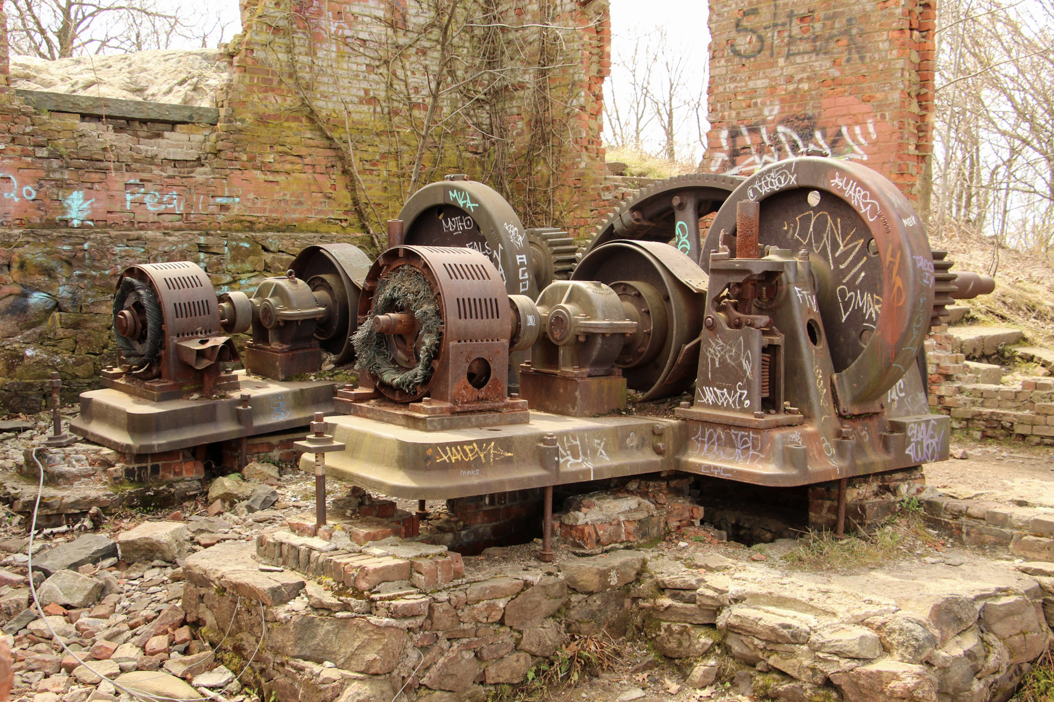
Mount Beacon is one of the most popular trails along the Hudson River. It offers different terrain for a good workout, old railway landmarks, and incredible views. The trail head starts at the parking lot where we found the information kiosk. From here, walk past the wooden gate and proceed along the gravel path on the red-blazed Casino Trail. We arrived at the ruins of the Mount Beacon Incline Railway. The railway was used as a tourist attraction for the views of the Hudson River as well as visiting a Casino Hotel at the top of the mountain in the early 1900s. This was the steepest railway in the world during its operation. Pretty wild! If you want to know more historic details, click here. After passing the ruins, we started making our way up the metal staircase continuing onto the red-blaze trail.
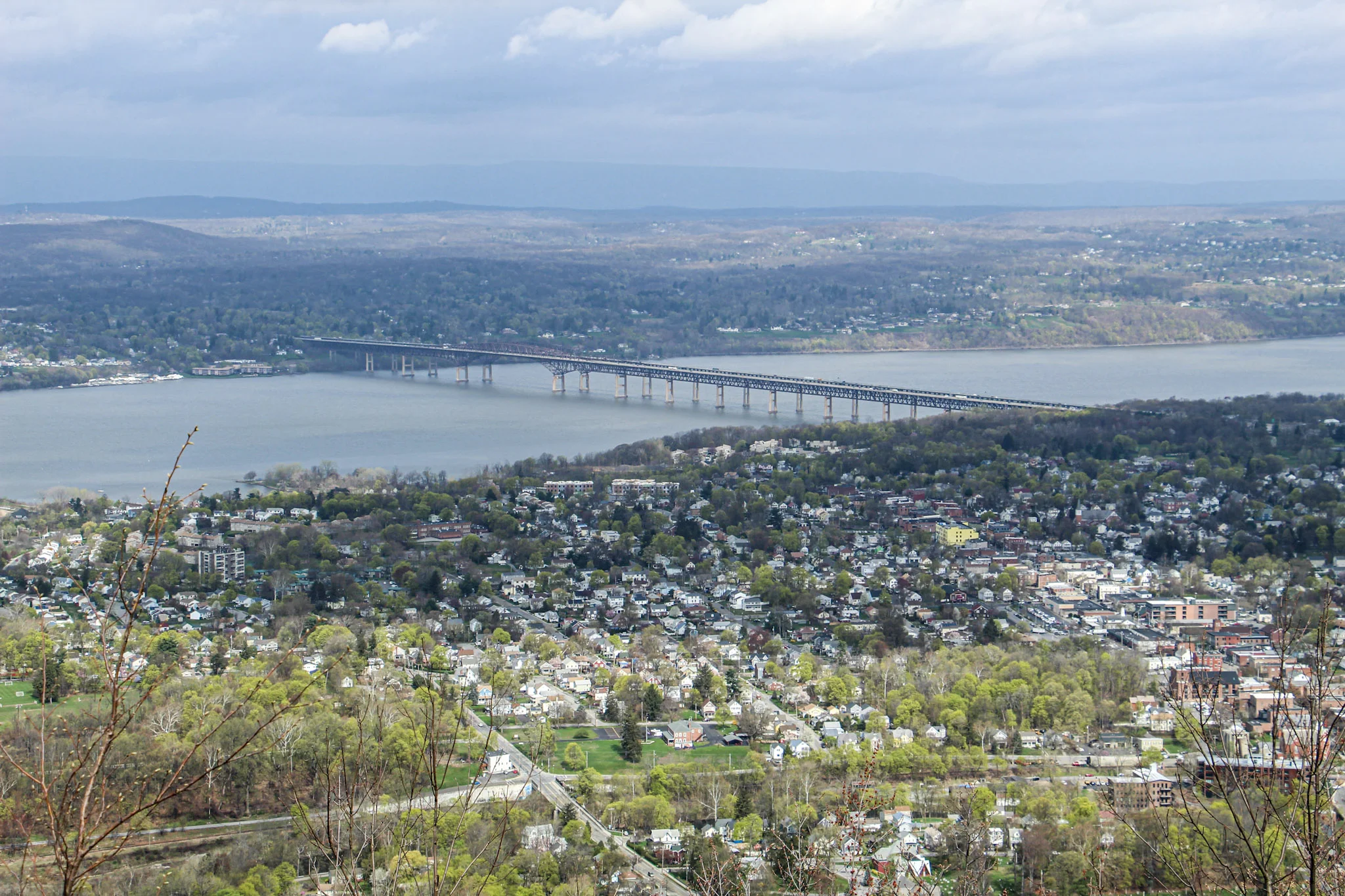
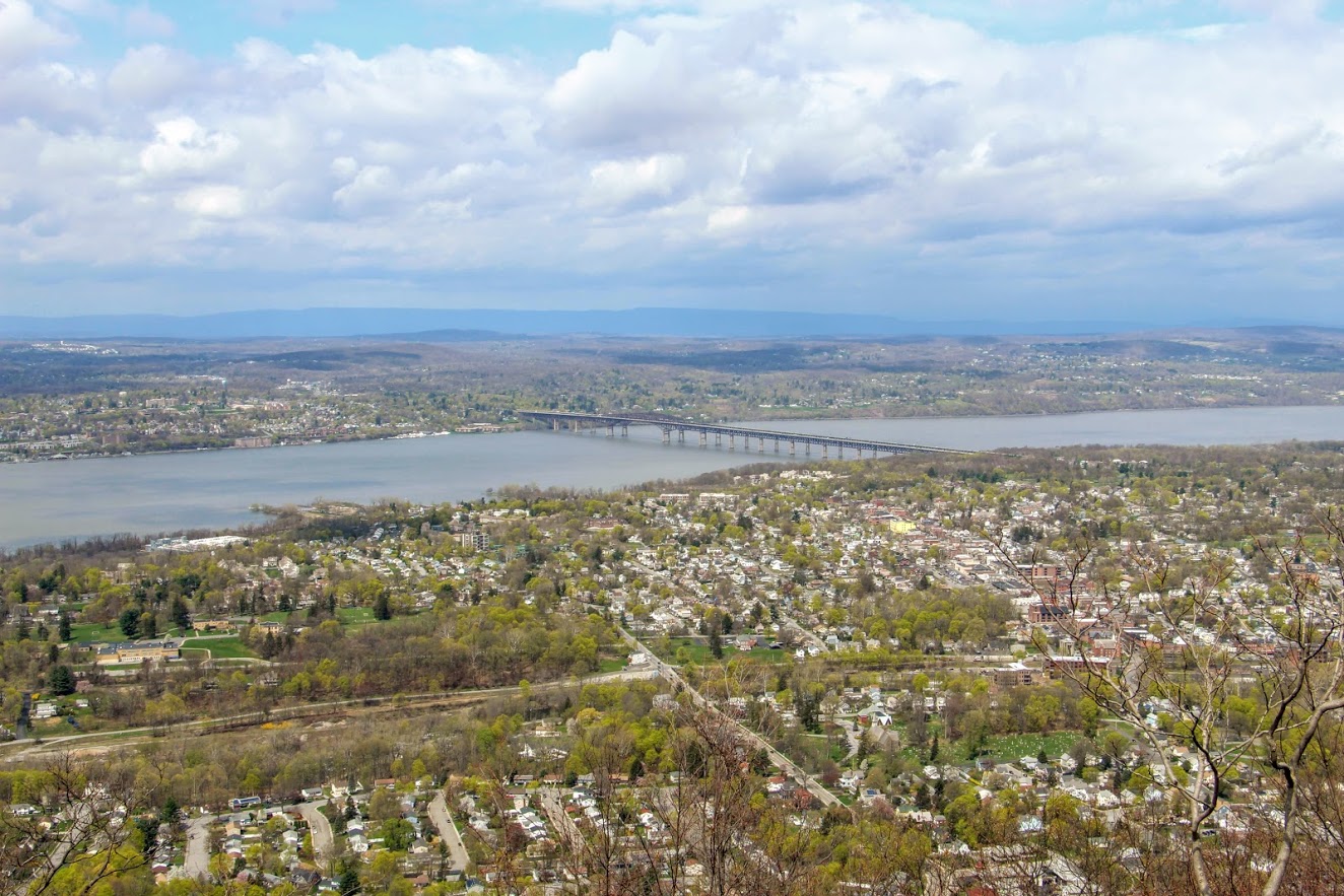
The tough part begins here, only for about a half mile. This is where you see happy faces coming down and not so happy faces going up. The hike will slowly begin to ascend up the mountain following the switchbacks. There may be areas that look unmarked but keep your eyes on the red markings. Eventually, the terrain will become rockier and even steeper uphill. Huffing and puffing our way up, the first glimpse of a view appears as we came up on the first landmark. The motor house of the railway has brick walls still standing and there you will find huge rusted gears and the motor. Past the motor house lies the foundation of what used to be the casino, which is where the first scenic view of the hike can be seen. The view from Mount Beacon stretches across the Hudson with stunning views overlooking Beacon. It is awesome that you can get this view only after hiking just over a mile. The hike started with overcast but amazingly the sky started opened up once we reached the overlook.
It was time to head toward the fire tower. We turned around from the look out, walked across the old casino ground toward the tower. Eventually, we noticed a red marking on a tree and followed that dirt road through two metal poles and continued on the red-blaze trail. We passed what looks to be a door or frame of an old car or truck on the trail. Additional steep climbing ensued for about 10-15 minutes until there is a clearing with a view of the fire tower. Shortly after, we arrived to the White trail. Before we reached the White Trail, we did notice an unmarked trail leading up the hill toward the fire tower but thanks to research we did not take that path. About 15 minutes later, we found ourselves making our way up the fire tower. This fire tower is pretty high. I was actually getting a bit nervous going up. By this time, the sky opened up completely and the views were an unbelievable 360 view. From the top, you will see Beacon Reservoir and Catskills to your northwest, the Newburgh-Beacon Bridge and Shawangunk Ridge to the west, and, to the south, the southern Hudson Highlands. Even as far down as NYC. And, probably more stuff I don’t even know! My girlfriend had to pry me off the tower. It was super windy but I just kept saying, “This is awesome”. Very fortunate to be able to have access to great hikes like this in the Hudson Valley. Oh, and there’s a donut shop 5 minutes away that is amazing for post hike donuts (Glazed Over Donuts blog post). I cannot recommend this hike enough!
More pics of the hike:


HIKING FOR DONUTS
Hi, I’m Mark. I live in Connecticut. I take new trips every change I get. A good trip has a great hike, great food, and something fun to do. My goal is to search out new trips and share them to inspire others to try something new and exciting.
If you are looking for posts in a particular place, search City or State here.
SEE OTHER POSTS IN ARCHIVE
Archive
RECOMMENDED POSTS
RECENT POSTS
See the latest on Instagram and follow @HIKINGFORDONUTS

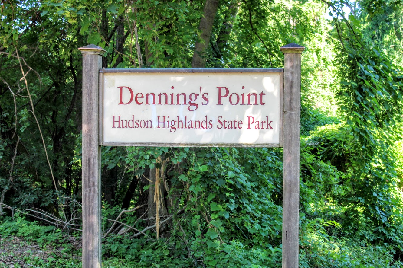
Dennings Point, Long Dock Park, Beacon, NY
Lock Dock Park Beacon, New York: Klara Sauer Trail to Dennings Point Trail
Trail Description: The Klara Sauer Trail is a flat walk until you meet up with the Dennings Point Trail along the shoreline. There are short access trails for views of the Hudson River and a beach with mountainous lookouts, where kayakers will often stop by onshore.
Trail Info:
Where: Long Dock Park, Beacon, NY Distance: 2.8 miles (1.5-2 hrs) Difficulty: Easy Trail Type: Out and Back Features: Bridge, Water, Mountains, Beach, River
How to get there:
GPS this address below. Easy to find.
23 Long Dock Rd Beacon, NY 12508
Hiking Tips:
At the time of my hike, storm damage caused trees to block the trail paths. If this is the case, turn around and go back the same way.
Make sure to stop at all access trails for additional views. Including the beach!
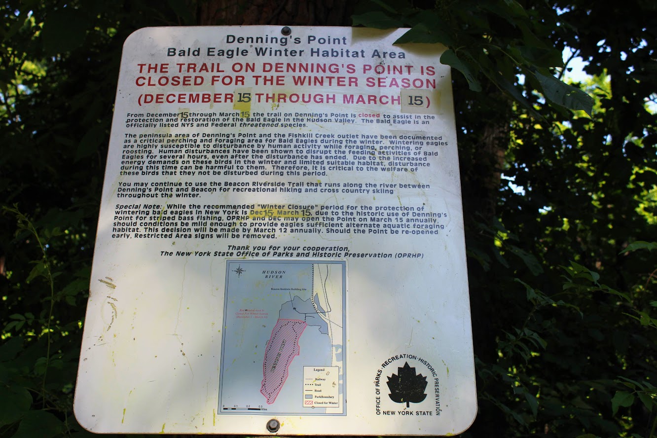
Denning’s Point Trail is closed December 15th to March 18th.
The Hike
Sometimes it is good to go for a nice leisurely walk, with an awesome view. The Hudson Valley is full of satisfying and challenging hiking trails with beautiful views. I am learning more and more about the area. There is a lot to offer if you are looking for outdoor activities. Short on time and looking for something easy, my girlfriend introduced me to a very cool spot located in Beacon, NY, called Long Dock Park.
path from the parking lot to the pier.
Upon arriving, I could see the fantastic view of the Hudson River as we parked. There is a good amount of parking but I can see this area being very busy. As we walked toward the pier, you will see trail maps within the park. Many people we saw were jogging, bike riding, and walking their dogs on the trails. You can also rent a kayak or paddleboard for the day. We walked out to the dock which is to the right of the parking lot. There are stools and fishing rod holders. A few fishermen were out bright and early on this day. From the dock, you get a fantastic view of the town across the river, including the bridge Beacon to Newburgh. This would be a good location to see the sunrise or sunset. The park has a very relaxing atmosphere.

Newburgh bridge from beacon.

View from the pier across the river.
Long Dock Park is connected to the Hudson Highlands State Park by a train track turned trail. Dennings Point is the northernmost area of the Hudson Highlands State Park, and is a peninsula that extends out in the Hudson River. That was our goal destination of the day. After checking out the views from the dock, we started our walk on the Klara Sauer Trail. This flat and easy trail will lead along the shoreline of Dennings Point. There are access trails to venture and see better views of the river along the way. Some lookouts were muddy so I am glad I had my hiking boots on.
Views from some of the access point along the klara sauer trail.
Ducklings going for a swim.
Hudson river view with some mountains.
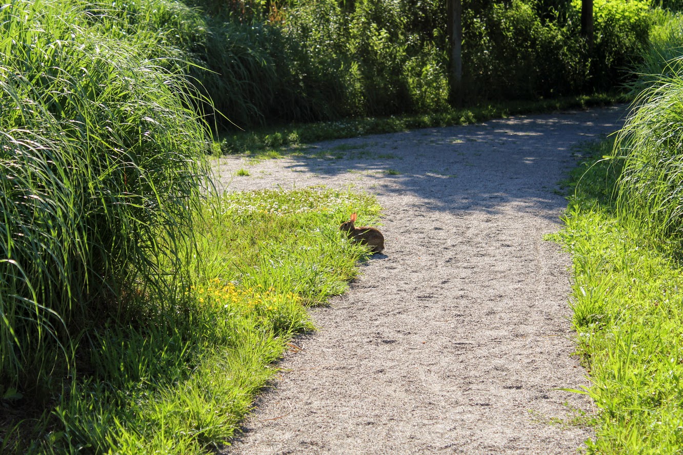
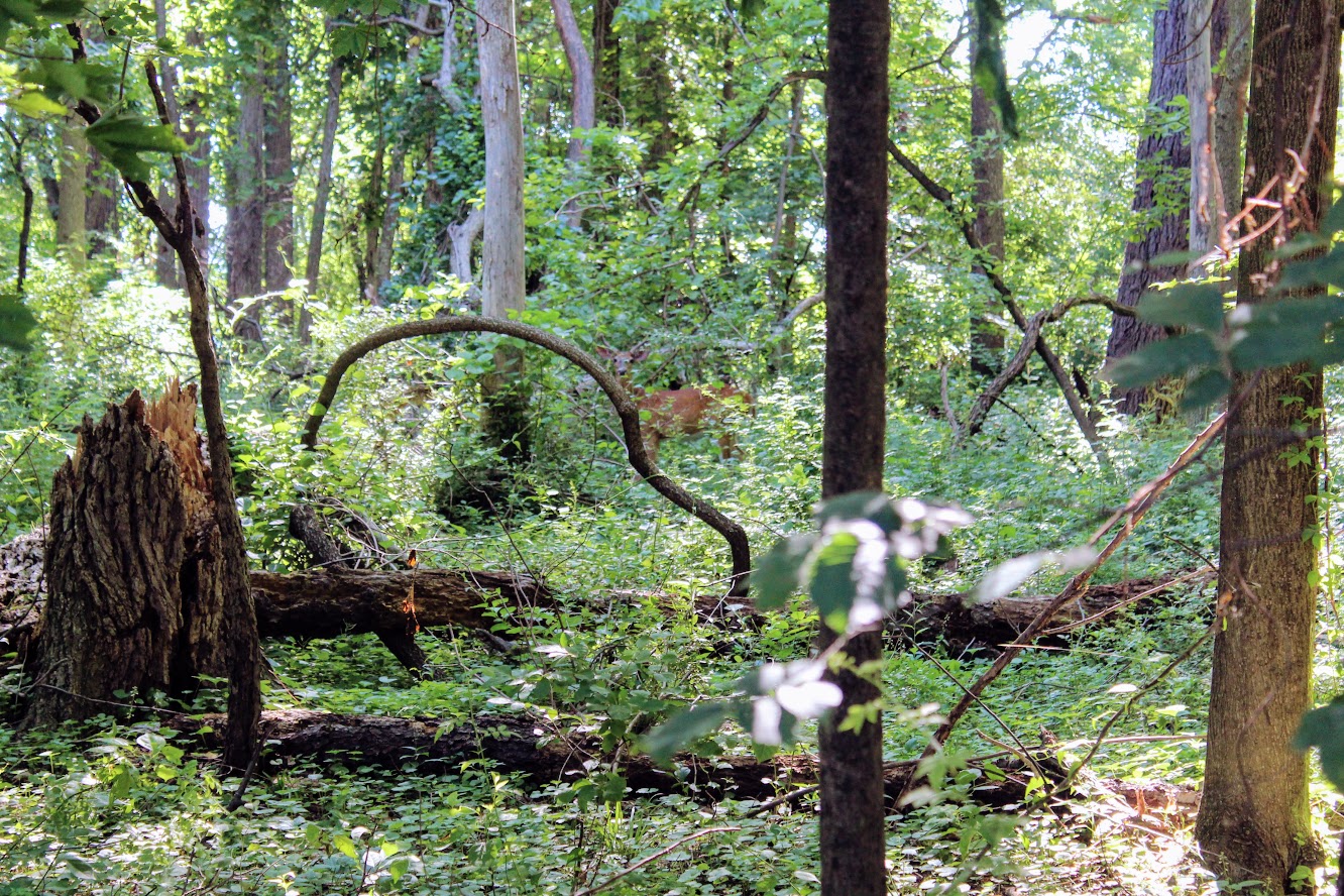
Unexpectedly, we did see more wildlife than anticipated. Peter Rabbit and Bambi made appearances.
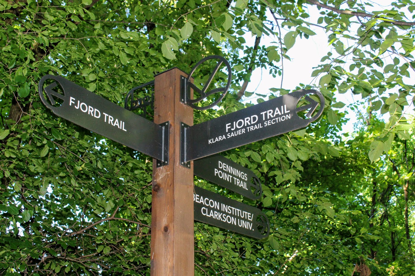
At the end of the Klara Sauer trail, we saw signs for the Dennings Point trail at the T intersection. Dennings Point trail was to our right. We did take a detour to our left on the Fjord trail to see the railroads tracks and caught a train going by under the bridge.
Railroads track if you veer on the trail to look for a train passing.
We circled back to follow the Dennings Point trail into the woods. We passed an abandoned building covered in tree branches where there was a brick factory many years ago. There will be a beach area path, where kayakers will stop for breaks, on your right. The beach front offered some impressive mountain views. Note, this trail is typically a loop but we reached an area that says to turn around due to the recent storm damage. We just turned around went back the same way.
when you run into this turn around the way you came!
views of kayakers and mOuntains.
views from the beach area of dennings point.
Great views.
This was a nice break from intense hiking. This was still great exercise. I would definitely come back. We walked about 2.8 miles and took us under 90 minutes. We got to see some great views. Long Dock Park is a great spot to kayak the Hudson River, do some fishing (may need a license), or just picnic with the friends and family.
love the views of the woods. trees down from storms on Dennings Point trail.

HIKING FOR DONUTS
A blog for the outdoors foodie enthusiast
Hi, I’m Mark. I live in Connecticut. I take new trips every chance I get. A good trip has a great hike, great food, and something fun to do. My goal is to search out new trips and share them to inspire others to try something new and exciting.
If you are looking for posts in a particular place, search by city or state here.
EXPLORE OTHER POSTS IN THE ARCHIVE
Archive
RECOMMENDED POSTS

MOST RECENT POSTS
See where I have been recently on Instagram. Follow @HIKINGFORDONUTS

Old Furnace State Park, Killingly, CT
Old Furnace State Park is located in Killingly near Rhode Island. This is a great park for hiking, biking, and fishing. Exploring new areas is always fun, even if you get lost on the trails. Check out the blog to make sure you stay on the trails!


Scrolling through the list of the 2018 Sky’s Limit Hiking Challenge in Connecticut, I wanted to explore unknown parts of the state that would be new to me. I haven’t spent much time in the Windham County area, neighboring Rhode Island. I really had no idea where I was going and there was not too much info on the park online. But, I convinced my girlfriend to drive over an hour with a promise of beers and off we went.
Old Furnace State Park is located in Killingly, CT. You will find the park entrance off Route 6 via Route 395. Ross Pond State Park is fairly close so my GPS took me there instead. If yours does the same, just keep going past that until you can take a left onto South Frontage Road and the park will be there on your left. The blue-blazed trail of this park runs about 3 miles. This particular hiking challenge calls for 2 miles round trip until you reach the overlook from the cliffs at 200 feet over Half Hill Pond. With this view you get a great look of valley stretching into Rhode Island.

We finally found the parking lot and noticed there was mountain biking event going on. Apparently, this is a big mountain biking trail. I didn’t expect to see anyone. The hiking trail starts at the parking lot. I used the trail located at ct.gov here . The path instantaneously takes you into the woods.

As we began, we crossed a small brook that led us to crossing a small footbridge.


The trail was fairly wide open until we reached an unmarked section ducking through a brush of bushes. We found ourselves questioning our direction. Eventually, a blue marker did appear.


From here the ascent started to get steep. About a mile into the hike, we saw the path break into two. Unfortunately, we kept going straight and that was not correct and saw some brown marked trails.


Thus, we circled back and took the path to the left which was the ridge along the pond. And, finally we found ourselves at the cliffs overlooking Half Hill Pond. The pond was completely filled with water lilies.


We stopped here because the trail was pretty buggy and I didn’t think the rest of the trail would offer much. But if you want to continue, this will lead you down to the parking lot and boat ramp at Ross Pond to Squaw Rock Road where you turn around and come back. If you are not from the area, the directions to the park could be difficult and the trail itself has areas that should be marked better. The hike itself was not hard. I would rate it easy. I would bring bug spray and pay very close attention for the blue markers. Looks like a good area to fish and maybe kayak as well. I’m sure this is a nice spot for locals but one time is probably enough for me.
The Review
Old Furnace State Park, Blue Trail, Killingly, CT (~2m): 2.5 out of 5.

HIKING FOR DONUTS
A blog for the outdoors foodie enthusiast
Hi, I’m Mark. I live in Connecticut. I take new trips every chance I get. A good trip has a great hike, great food, and something fun to do. My goal is to search out new trips and share them to inspire others to try something new and exciting.
If you are looking for posts in a particular place, search by city or state here.
EXPLORE OTHER POSTS IN THE ARCHIVE
Archive
RECOMMENDED POSTS
MOST RECENT POSTS
See where I have been recently on Instagram. Follow @HIKINGFORDONUTS

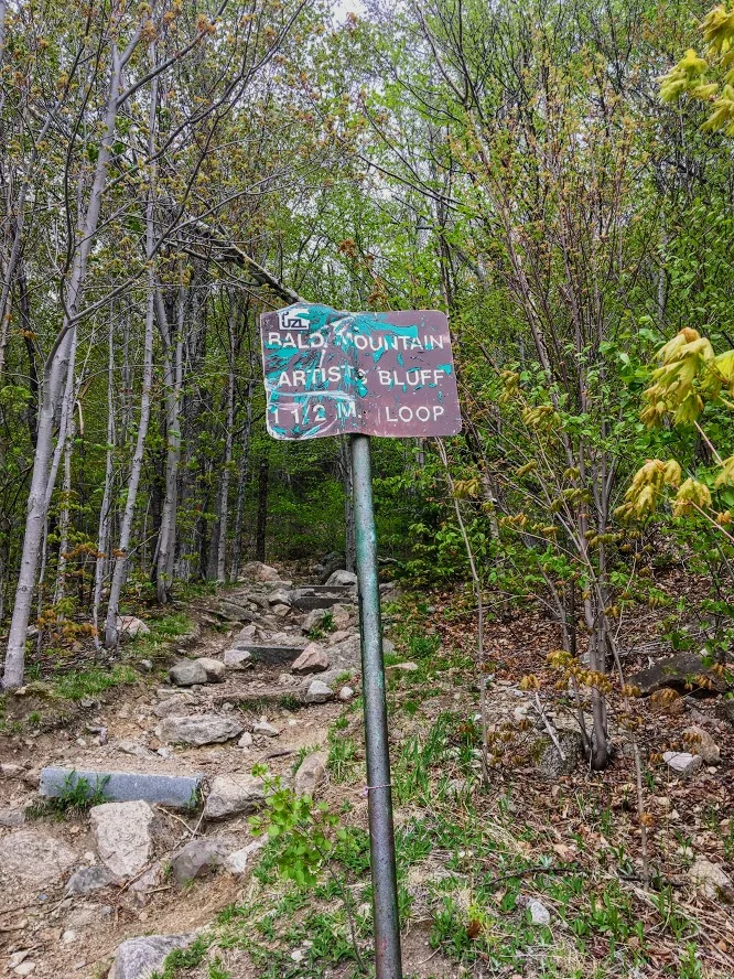
Artists Bluff Trail, Franconia Notch State Park
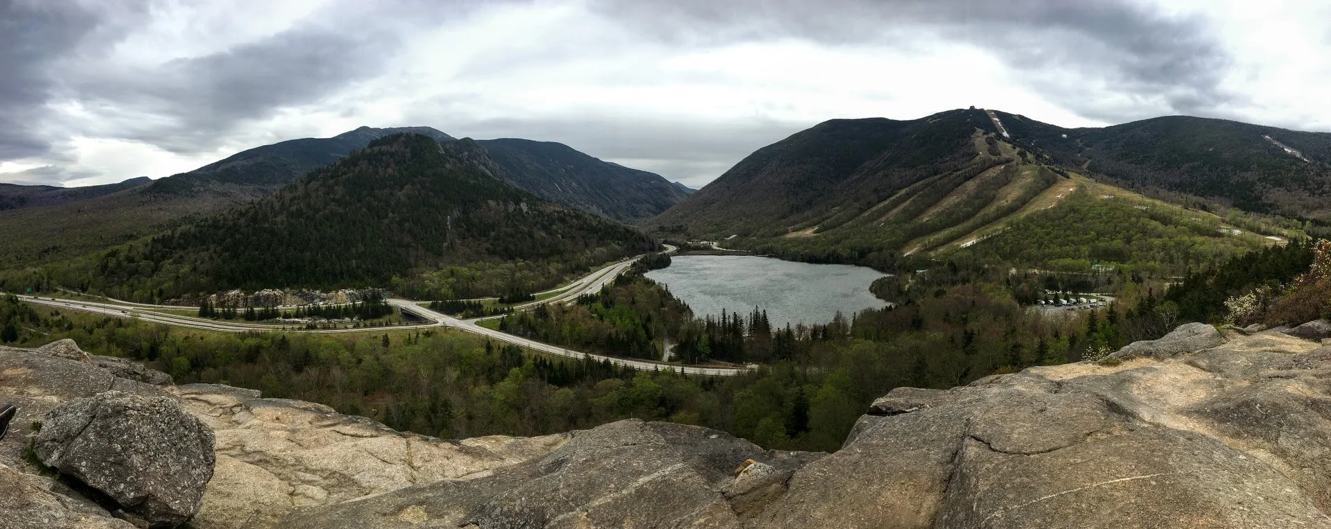
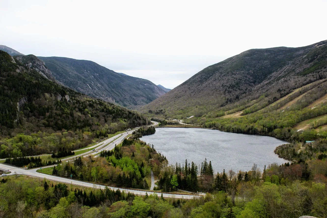
Artists Bluff is one of my favorite trails in the White Mountains of New Hampshire located in Franconia Notch State Park. This trail checks off all boxes for a great hike. The views are spectacular. Check it out!
Trail Description: The Artists Bluff Trail is a short hike that offers some of the best views of Cannon Mountain and Franconia Notch.
Trail Info:
Where: Franconia Notch State Park, Franconia, NH Distance: 1.5 miles (1-1.5 hrs) Difficulty: Easy to Moderate Trail Type: Out and Back Features: Views, Valley, Lake, Forest
How to get there:
From I-93 (Franconia Notch Parkway) get off on Exit 34C toward the Cannon Mountain Ski Resort and head west on NH 18. Go up roughly a half mile where you see a large parking area on your right. Walking across the empty lot in front of you will lead to the signs for the Artists Bluff and Bald Mountain.
Hiking Tips
Shortly along the trail, there’s a fork in the path that not clear which direction to go. Stay to your right to follow the Artist Bluff Trail. The other option will take you on the Bald Mountain Trail and will take you longer to get to Artists Bluff.
Great fall hike with amazing foliage.
The Hike
If you are looking for a great trail with amazing views that is relatively quick in New Hampshire, the Artists Bluff Trail in Franconia Notch State Park is exactly that. My friend owns a house close by and about 10 of us drove up for the weekend. After having too many beverages the night before, we wanted something relatively short on this morning. And, we wanted to beat the rain that was inevitable. We have hiked Artists Bluff in the past but it is a great hike and it is very satisfying. The loop is only 1.5 miles but it is challenging with steep sections. And, the trail will lead you to amazing views of Cannon Mountain and Franconia Notch.
Upon arriving we saw the parking lot off Route 18 on your right across from the Cannon Peabody slopes. We walked across the empty lot in front of us that led us to the signs of the start of trail for Artists Bluff and Bald Mountain.

We followed the Red marked trails to get to the bluffs. The trail starts off pretty easy then you have some steep inclines and declines as you get closer to the bluffs.


About .25 miles or so into the hike we saw split in the path to hike up to the summit of Bald Mountain on our left. This will add .5 miles to the hike. As we wanted to beat the rain, we stayed the course toward Artists Bluffs.

The trail eventually broke into the open and I saw views of Cannon Mountain. There was a storm recently in the Northeast and there were actually quite a bit of trees knocked down. I came across volunteers doing some maintenance to the trail and trying to clean up. After passing the volunteers, I came up to the rock that points to the direction of the bluffs.

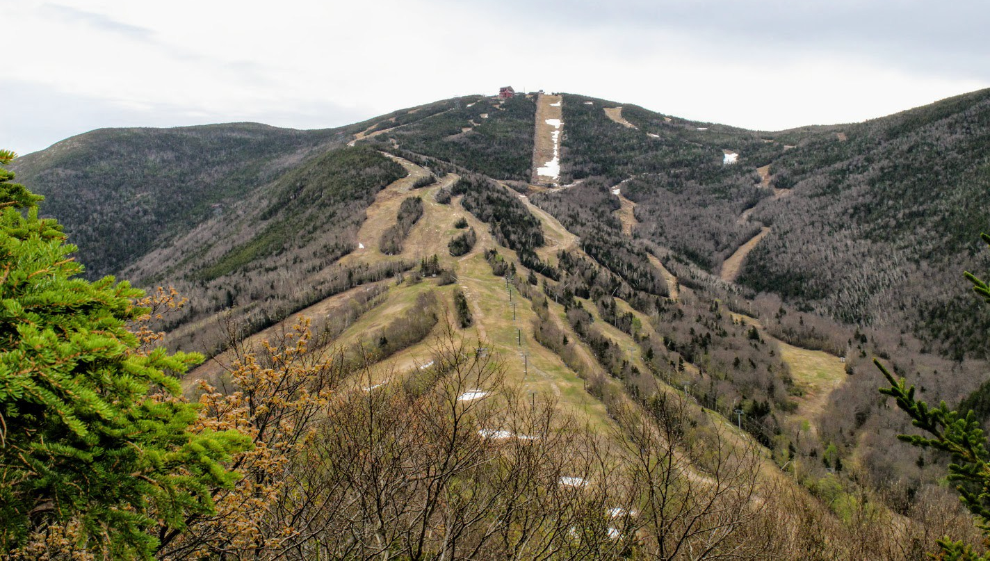
Artists Bluff stands at 2,368 feet high. The views at the top are amazing. You get a great outlook of the Franconia Notch. We hung out for about a half hour at the top reminiscing and questioning prior nights beverage consumption. And, then we decided to head back. The initial descend was pretty tough and rocky but the trail got easier as the path took us along Route 18 across from Echo Lake. And, this took us to where we originally started.

I would do this hike again and likely many more times. Each season of the year I am sure you get different views. Fall foliage would be the best. The trail is well marked and the forest is beautiful. Even though this is close to the highway, it is still far enough away and quiet as you hike. For a hike in the White Mountains, I would say this was an easy level hike. However, I could see this trail being moderate for others due to some the steeper sections. The hike will only take about an hour. But you will always add 20-30 minutes at the top taking in the views. The only thing that would have made this better is if I had some donuts with me!

HIKING FOR DONUTS
A blog for the outdoors foodie enthusiast
Hi, I’m Mark. I live in Connecticut. I take new trips every chance I get. A good trip has a great hike, great food, and something fun to do. My goal is to search out new trips and share them to inspire others to try something new and exciting.
If you are looking for posts in a particular place, search by city or state here.
EXPLORE OTHER POSTS IN THE ARCHIVE
Archive
RECOMMENDED POSTS

MOST RECENT POSTS
See where I have been recently on Instagram. Follow @HIKINGFORDONUTS

Hancock Brook Trail, Waterbury, CT
Spring weather is finally upon us. As summer approaches, I look forward to finding new hiking trails. I came across Hancock Brook on Instagram and the hike surprised me. And, no it's not closed. Read up on my advice to make sure you complete this trail!


It has been a long, very long winter in the Northeast. The weather finally felt like spring and that means it was time to find some new trails to hike. I came across the Hancock Brook Trail in Waterbury, CT on Instagram from some fellow CT hikers I follow. I never heard of it and the views looked cool. However, my research displayed this trail was closed including sites like Alltrails. After seeing recent posts and finding one actual site with directions on this trail, I felt comfortable enough to give it a go. And, I can confirm the trail is NOT closed. People are giving up too easily. Yes, there is a rotted bridge but the trail can be accessed elsewhere. For directions, plug into your GPS: Sheffield St., Waterbury, CT, 060704. Drive all the way down until you hit the quarry and there is a small parking lot to your right.
The Hancock Brook Trail is a blue-blaze trail along the edge of the Mattatuck State Forest. This hike is a 2.8 mile loop. The terrain does get quite rocky, which includes steep uphill and downhill portions and some climbing. The trail was covered in leaves on this day and was quite slippery because of that. I would consider this a moderately difficult hike for the average hiker.

Onto to the infamous bridge I kept reading about. Ignore the bridge.

From the parking area, you will start walking up the side of the quarry and look for the first Blue marker. Upon entering the woods, the trail splits and the trail to the right with one blue marker will take you along Hancock Brook. The first half mile or so will give views of the stream and its rapids. The trail is fairly narrow and gets unpleasant as you reach the inclines where the bushes have grown into the trail.


You will reach a spot in the trail where you hear lots of trucks and work on the quarry. There will be a sign to stay on the blazed trail on a tree with the Blue marker.

Continue this direction and go straight. This is a tricky part of the trail. The markings are not great until you reach the peak. You will want to veer right but that will take you the wrong way. There is a like a raised branch signaling not to go this way. If not, you will reach a small pond and you will see a very sketchy trailer. Do not go there. That is not part of the trail. You will be too close for comfort. Turn around. I just envisioned all the crazy TV shows I saw with a crazy dude coming out of a trailer and chasing me.

If you went the right way, you will reach the pond and see the trailer across far enough away. You need to make an abrupt left into the woods to start the incline. Once you do not see blue markings, stop and just turn around. We walked by it as well. I took pictures for guidance. The blue marker was covered by trees.
The trail will get tougher at this stage as you enter a pine forest. There is a mini pond with a bunch of trees down as you get closer to the ascend uphill. Keep an eye out for the blue markings. They are a little too far apart in this area. Once you pass this pond, the steep uphill will begin and there will be some switchbacks.

This tough stretch will be worth it as you will reach a beautiful lookout spot for views. The rock formation is called Lion Head and is the peak at 660 feet. This is a great spot to stop and soak in nature. Have a snack and fuel up on water. Maybe eat a donut.


The climb down was tough at first but got pretty easy as we kept going. And, the trail markings were way better. The spots where they were too far apart, I suggest going the way that made sense and you will find them. You will pass a few more lookout points to enjoy more views along the way.


At the end of trail, there will be a steep downhill section before you reach the quarry where you started. And, somehow we completely missed the waterfall coming in, or the water started to come down from melting while we hiked. Before we left, we took a closer look at what is called Hancock Cascades. This was to the left at the end of the final descend.


This was a surprisingly good hike. This took us about 2 hours and that is with stopping for 20 minutes. I don’t think I would have found it without Instagram. The hike was fun and didn’t take too much time. I would just be careful of the markers. There were times where it was lacking and you really had to keep an eye out. And, stay away from the Breaking Bad looking trailer!
Trail Review:
Hancock Brook Trail, Waterbury, CT (2.8m): 3 out of 5


HIKING FOR DONUTS
A blog for the outdoors foodie enthusiast
Hi, I’m Mark. I live in Connecticut. I take new trips every chance I get. A good trip has a great hike, great food, and something fun to do. My goal is to search out new trips and share them to inspire others to try something new and exciting.
If you are looking for posts in a particular place, search by city or state here.
EXPLORE OTHER POSTS IN THE ARCHIVE
Archive
RECOMMENDED POSTS

MOST RECENT POSTS
See where I have been recently on Instagram. Follow @HIKINGFORDONUTS

Winter is here...in the Basin
Fun weekend back in New Hampshire. This time I made a trip back to Franconia Notch State Park and hiked to the Basin. A pretty, cool spot that is very accessible.

It was time for another trek up to New Hampshire. After a few brewery stops, we finally made it up to my friend’s house. And, there was snow on the ground! Even though weather was in 20s, we still wanted to enjoy the outdoors New Hampshire has to offer. My friend decided The Basin in Franconia Notch State Park would be a good “jaunt” for the 5 of us and our friend’s puppy. The trail and parking lot is right off the highway off I-93. We parked at the visitor center and just hopped on the trail towards the Basin. This trail was mostly flat but due to the snow and ice, it was more tricky. In nicer weather, this is a very easy walk, paved most of the way and offers handicapped accessible viewing as well. We walked over a few bridges and eventually came across some cool waterfalls. We then made our way to The Basin, which offers rushing waters that has eroded the rock into a smooth, circular cave-like formation. After seeing that we walked a little further before the Pemi Trail and started our way back to the cars. Our hike was roughly 3.5 miles. Even though it was quite cold, it was a beautiful day to be outside. We enjoyed our mascot keeping us on our toes. Always fun to see a pup’s first time in the snow. Another reminder to get out there and enjoy time with friends!


HIKING FOR DONUTS
A blog for the outdoors foodie enthusiast
Hi, I’m Mark. I live in Connecticut. I take new trips every chance I get. A good trip has a great hike, great food, and something fun to do. My goal is to search out new trips and share them to inspire others to try something new and exciting.
If you are looking for posts in a particular place, search by city or state here.
EXPLORE OTHER POSTS IN THE ARCHIVE
Archive
RECOMMENDED POSTS
MOST RECENT POSTS
See where I have been recently on Instagram. Follow @HIKINGFORDONUTS

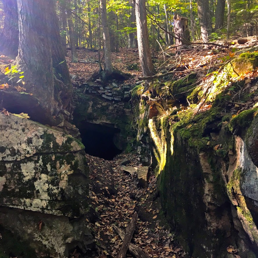
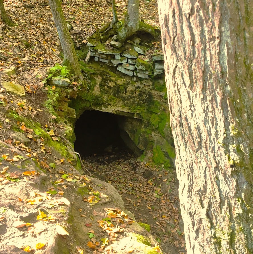
Mine Hill Preserve Trail, Roxbury, CT
More fun fall hikes in CT! The fall colors are really showing now. I decided to hike a new trail this time. I chose Mine Hill Reserve Trail in Roxbury, CT. The trail was unique and offered cool historic features. Check it out for great leaf peeper pics.
Trail Description: The Mine Hill Preserve trail is part of the Roxbury Land Trust as a national historical landmark. Venturing on this trail will take you through scenic woodlands, rocky terrain, mine tunnels, bat caves, and old furnace structures from the 19th century.
Trail Info:
Where: Roxbury, CT
Distance 3.6 miles (2 hrs)
Difficulty: Easy to Moderate
Trail Type: Loop
Features: Water, Bat Caves, Quarry, Bridge, Mine Tunnels, Old Furnaces
How to get there:
6 Mine Hill Road, Roxbury, CT 06783
The GPS lost signal as I got on Mine Hill Road, but just follow the signs on the gravel road to the parking lot.
Hiking Tips
Download a map of the trail, http://www.roxburylandtrust.org/MapMineHill.pdf.
Veer left to start with the more difficult section toward the Donkey Trail. The latter part of the trail is more like a brisk nature walk on flat ground.
The Hike
This past weekend’s hike was recommended by a friend. Nichole and I took a ride out to Roxbury, CT to the Mine Hill Preserve Trail. This trail offers some unique features where you will see various mines and old furnace stoves from the 19th century. This is definitely off the beaten path. There is a very small parking lot where the trail heads start. There are only two trails here. There is a 3.6m loop (blue trail- Mine Hill Preserve) and an additional 2m loop can be added (red trail – Carter Reserve). Due to time constraints, we just did the blue trail loop. The maps online for this area are very helpful too. I would suggest downloading here prior to the hike. The trails are a short walk from the parking lot. If you really wanted to just see the old furnace structures, this is only a 10 minute walk from the start if you veer right. Prior to hiking, I read the veering to the left would get the difficult portion of the hike done and that is what we chose.

In this direction, you pass a small pond to your right.

The main loop ascends up the Donkey Trail and here you will pass two mine tunnels.


The terrain was pretty interesting and varied. This side of the loop was by far the most challenging. It was very rocky and had some steep uphill areas. As you keep hiking , you will cross paths with multiple bat cages that serve as entry ways for the caves inside them.


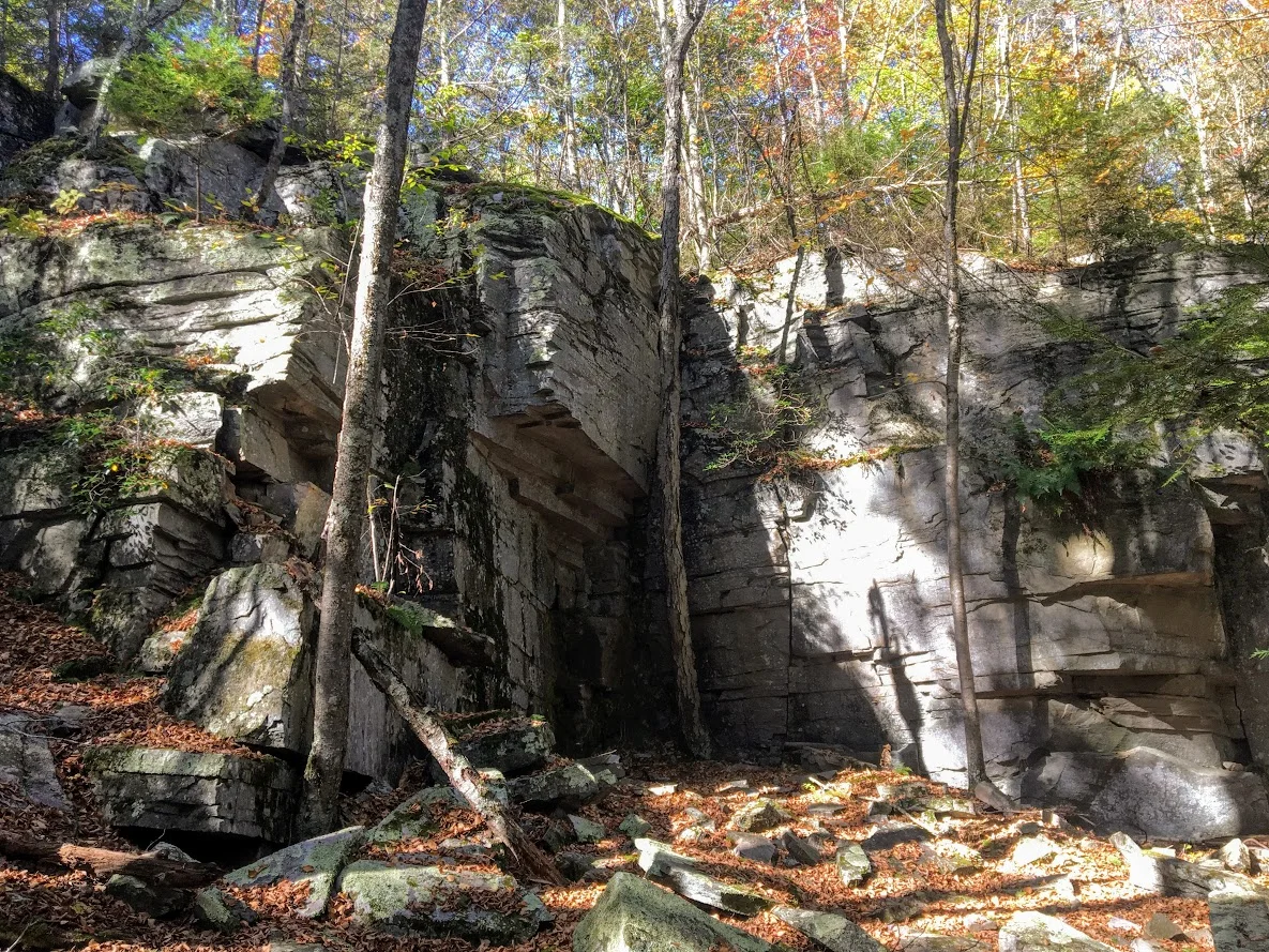
The trails begins to descend and you will meet at the Old Quarry bridge which joins a dirt road that will lead you to the other side of the loop. The other side of the loop was more of a nature path. It was flat the whole way, roughly 1.5m. This was less interesting until the end where you will find the old forge site. The fall colors kept me attentive along the way.
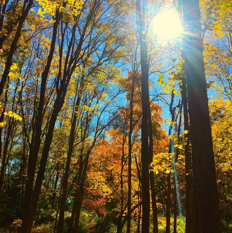


Overall, the historic points of the trail offered a different features you don’t get on hikes generally. The trail was very maintained and marked well. The hike would be good for anyone beginner to advanced. I would recommend hiking boots since the terrain can be rocky. The loop didn’t take us too long, about 1 hr 45 min. Next time, I would leave more time and add the additional 2m loop. Pretty good recommendation!
Review:
Mine Hill Reserve Trail, 3.6m (Roxbury, CT): 3.5 out of 5

HIKING FOR DONUTS
A blog for the outdoors foodie enthusiast
Hi, I’m Mark. I live in Connecticut. I take new trips every chance I get. A good trip has a great hike, great food, and something fun to do. My goal is to search out new trips and share them to inspire others to try something new and exciting.
If you are looking for posts in a particular place, search by city or state here.
EXPLORE OTHER POSTS IN THE ARCHIVE
Archive
RECOMMENDED POSTS

MOST RECENT POSTS
See where I have been recently on Instagram. Follow @HIKINGFORDONUTS

Chauncey Peak Trail, Giuffrida Park, Meriden, CT
It is leaf peeper season here in the Northeast. There is no better time to go hiking than in the fall. I am going to attempt as many hikes as I can get in. Here's the first of many! And, one of my favorites.
Trail Description: Located in Guiffrida Park, the Chauncey Peak Trail offers a scenic hike with beautiful ridge line views of Bradley Hubbard Reservoir.
Trail Info:
Where: Guiffrida Park, Meriden, CT Distance: 2.8 miles (2-2.5 hrs) Difficulty: Moderate Trail Type: Loop Features: Views, Reservoir, Lake, Peak
How to get there:
This is fairly easy. Just GPS Guiffrida Park and the address should be 800 Westfield Rd, Meriden, CT 06450. Once you pull in, you will see the parking lot.
Hiking Tips
Start the hike to the right of the parking lot into the forest. Much easier route going up and down.
The trail has been updated and re-routed. Be sure to follow the blue trail around Chauncey Peak and past the landfill. Look for the Blue markings.
There are many great views from the ridge line, be sure to take them all in.
The Hike
It is officially fall. It is chilly in the morning, the leaves are changing, and it is getting darker out earlier. Time to get out there and be a leaf peeper. Sounds kind of sketchy…..But seriously, fall hikes are the best. I slacked a little bit this summer with hiking, but I intend to take advantage of the fall weather.
For my first fall hike, I chose the Chauncey Peak Trail at Giuffrida Park in Meriden, CT. This is my favorite hike in the Hartford area, hands down. I have hiked this trail multiple times and I enjoy it just as much each time. This is a very fun hike with great scenic views and a variety of terrains overlooking Bradley Hubbard Reservoir. Unfortunately, due to the fog on this day, it was tough to get that view in. I like to start the hike veering to the right under the trees into the woods on the Blue trail. You will get the strenuous part of the hike done in the beginning. You will immediately be on the incline ascent up the peak, this will be steep and rocky stretch. This won’t last too long. Once you get to the top, you will keep following the blue trail and this will bring you to the ridge line for great panoramic views. Once you are done taking hundreds of pictures, you will descend down until you meet a footbridge that takes you to the bottom of the reservoir. You will follow out the blue trail to the white trail along the water’s edge to the parking lot. This part will be flat and serves as a nice cool down.
The trail is well marked. They are taking great care of it. When I hiked this originally I got lost but since then the markings have greatly improved.I would consider this a moderate hike. You need hiking boots. Depending on the weather, it can be very slippery. I was slipping on the leaves and loose rocks myself due to some wetness. I finished hiking under 2 hrs. If you want a nice short day hiking with challenge and rewarding views, I highly recommend this trail.
Review:
Chauncey Peak Trail, 2.8m (Meriden, CT): 4.5 out of 5
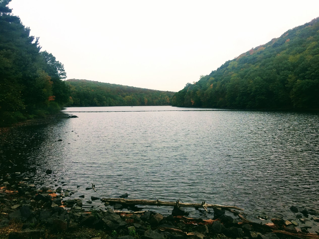
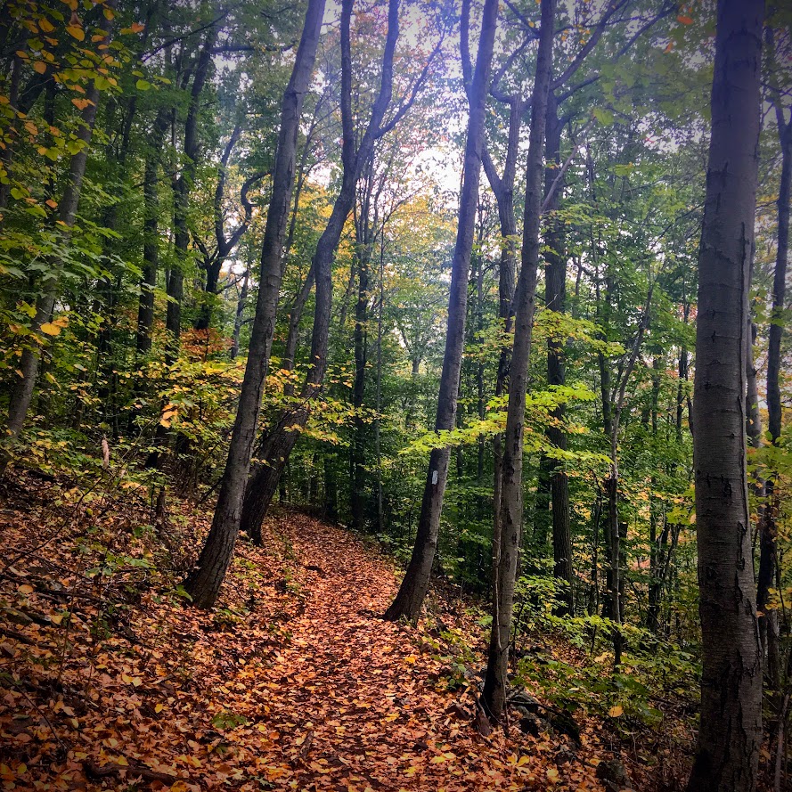
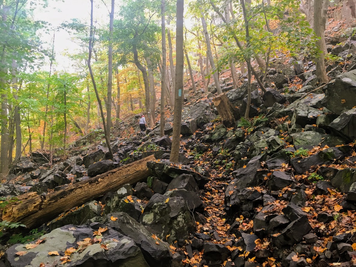
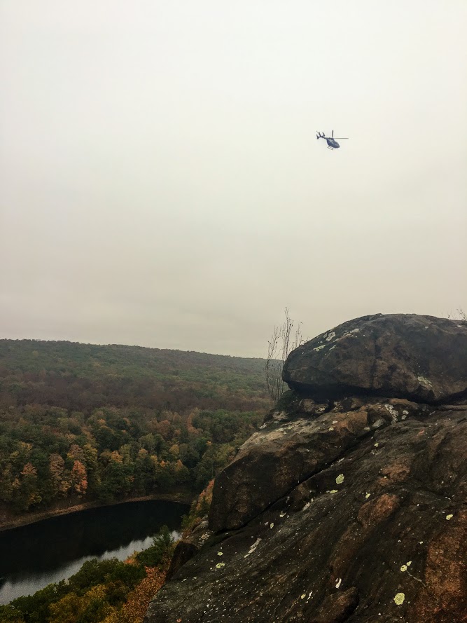
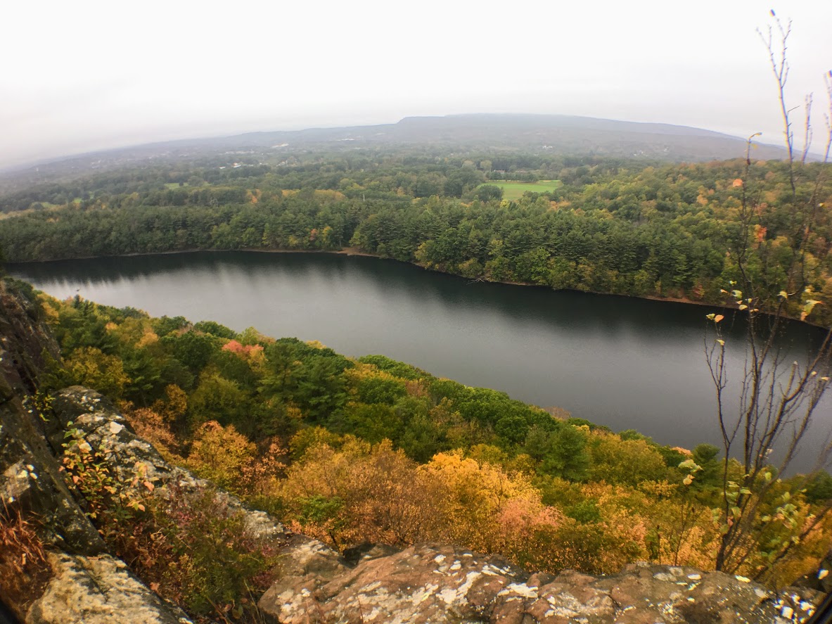
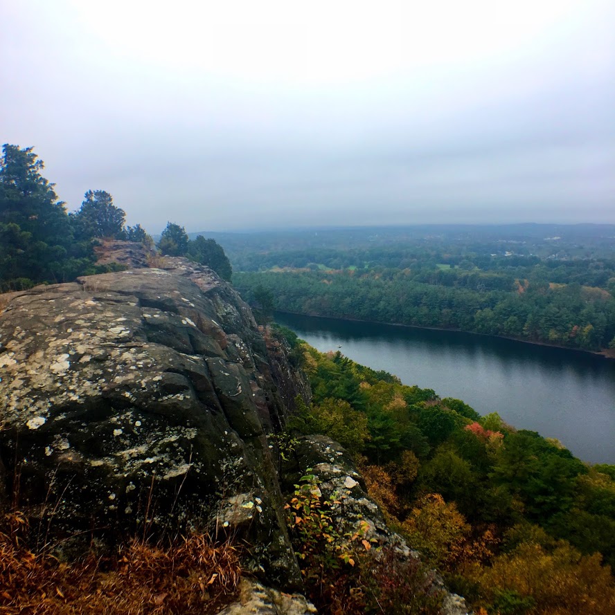
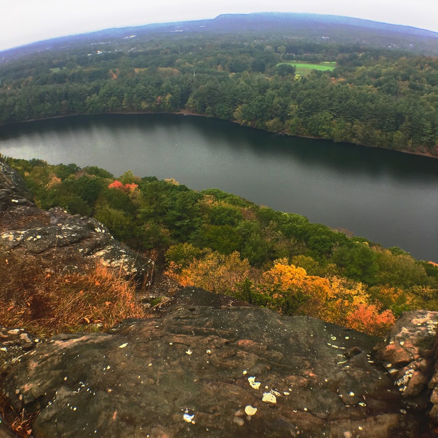
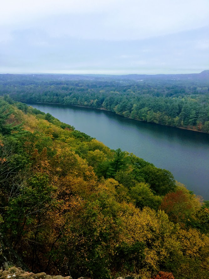
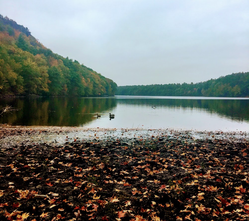
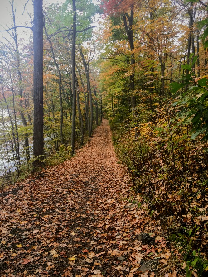
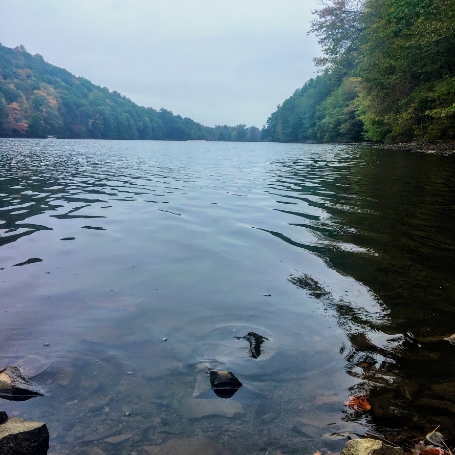

HIKING FOR DONUTS
A blog for the outdoors foodie enthusiast
Hi, I’m Mark. I live in Connecticut. I take new trips every chance I get. A good trip has a great hike, great food, and something fun to do. My goal is to search out new trips and share them to inspire others to try something new and exciting.
If you are looking for posts in a particular place, search by city or state here.
EXPLORE OTHER POSTS IN THE ARCHIVE
Archive
RECOMMENDED POSTS
MOST RECENT POSTS
See where I have been recently on Instagram. Follow @HIKINGFORDONUTS
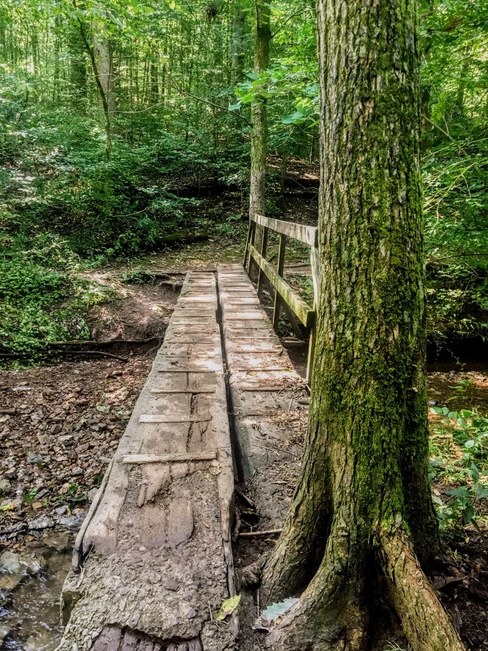
Honky Tonk Hiking in Nashville, TN!
Spent the long labor day weekend hiking in Nashville, TN! Aside from bars, music & food, I was able to enjoy some great outdoor activities. Got a hike in and explored a lake. Nashville hikes.

It has been a busy month….and a very busy summer. The last trip on my agenda for the summer was Nashville, TN. I have never been there before and I hear lots of great things. My girlfriend, Nichole, has been there 4 times now. She was tasked with showing me the ropes. Aside from the food and the bars, we made time for some outdoors activities and adventuring. I did some research found some cool parks nearby such as The Warner Parks. We decided to rent a car for the day and made our trek ready to sweat off the beers, biscuits, and hot chicken.
We stayed in downtown Nashville and made the 20 minute drive to Edwin Warner Park first. Here is where we started with a nice refreshing hike. The weather held up for us and was perfect. The park was easy to get to and there is ample parking. There is a nature center for water and bathrooms also.

We decided to take the Harpeth Woods Trail, which was roughly a 2.5 mile loop. There are three trailheads in Edwin Warner Park which access the trail: Owl Hollow, Natchez Trace Trailhead, or the Nature Center Trailhead. We walked further down from the Nature Center and started at the Natchez Trace Trailhead. The Harpeth Woods Trail is the blue trail. The trail is very well marked, all we needed to do is follow the blue arrows. Please note, this is a very popular park. We were there on Labor Day but there isn’t a lot of options in the metro Nashville area.


This particular hike was a typical woodsy trail. No scenic views but a good hike. There were some cool rocks formations and bridges to cross. There was a small part of the hike that was a nice incline but that was maybe 1/10 of a mile. In my opinion, this was an easy hike based on my abilities. I wore Nike training shoes and have a bum ankle still. However, I can see this being moderate for others. I did my best to take unique pics.


After the hike, we decided to venture to Percy Warner Park as well since it was only a mile away. At this location, there is a cool landmark known as the Percy Warner Park Stairs. This gives you a nice burn going up and a view from the top from where the trail heads start.


The last stop was Radnor Lake. This location was only 20 minutes from the Warner Parks. Since we had the rental car, we figured we would try to get in as much as possible. This area was very, very busy and parking was an issue. There are two parking entrances. One lot was completely full. However, it is was a really nice ride to both entrances. We got to see pretty nice houses and scenic views. Nichole even questioned some houses, "I wonder if someone famous lives here." Once we got a parking space, we just quickly perused the lake and went on the bridge to see some views. It’s cool for the area and I understand the traffic. This sums up our labor day in Nashville. I didn’t anticipate getting this much outdoors in so close to the city.


HIKING FOR DONUTS
A blog for the outdoors foodie enthusiast
Hi, I’m Mark. I live in Connecticut. I take new trips every chance I get. A good trip has a great hike, great food, and something fun to do. My goal is to search out new trips and share them to inspire others to try something new and exciting.
If you are looking for posts in a particular place, search by city or state here.
EXPLORE OTHER POSTS IN THE ARCHIVE
Archive
RECOMMENDED POSTS
MOST RECENT POSTS
See where I have been recently on Instagram. Follow @HIKINGFORDONUTS

Mount Lafayette, New Hampshire
The White Mountains in New Hampshire is one of my favorites areas to hike. On this day, I conquered Mount Lafayette. What a hike!
Trail Description: Mount Lafayette is the highest peak in the Franconia Ridge at 5,260 feet. The summit offers amazing 360 views of the Pemigewasset Wilderness Area.
Trail Info:
Where: Lincoln, NH Distance: 8.0 miles (7-8 hrs) Difficulty: Hard Trail Type: Out and Back Features: Views, Peaks, Mountains, Greenleaf Hut
How to get there:
The parking lot for this hike is located in Franconia Notch on I-93. You can park on either side of the Interstate. Traveling north, you can park in the trailhead lot for the Falling Waters and Old Bridle Path trails. Traveling south, take exit 34b at Lafayette Place Campground. Follow the foot tunnel that goes under I-93 to the parking lot the opposite side of the highway to start the trail.
Hiking Tips
Bring lots of water, wear your best boots, hiking poles, and pack snacks.
Suggest doing the loop version of this hike along the Franconia Ridge trail to see Mount Lincoln and Little Haystack for more views.
Due to the popularity, the trail can be very crowded.
The White Mountains in New Hampshire are one of my favorite areas to visit and go hiking. It is one of the coolest areas in the Northeast and makes me feel like I’m in a different part of Unites States. It has a pacific coast mountainous look. I try to do a few hikes a year in New Hampshire. A large group of my friends rent houses in the area a few times a year to hang out. Even better, my best friend recently purchased a vacation home close to this area, about 15 minutes from Franconia. I bought new hiking boots and figured I wanted to do a fun, difficult hike in the White Mountains. More specifically, a hike I have not done. The one hike I really wanted to do was the Mount Lafayette summit. My friend said it was “easier” than Mount Washington but still hard. Lies. It was really freakin’ difficult. And, a terrible decision to wear new boots.
By the time we got there, it was near 11am and my friend suggested shaving a mile off the hike by skipping the trails where you would see Mt Lincoln and Little Haystack. I was against this decision but I was overruled. Disclaimer: This is a very popular hike. One of the best New England has to offer. There were cars lined up the side of the roads and the lots were full. This created a very tight hiking path. There was a lot of stopping and waiting for other hikers as the paths can be very narrow. For a summer hike, the weather was perfect, mid-70s and the skies were sunny and clear. We made our way to the trail which begins to the right of the information sign (there are bathrooms as well). Most hikers choose to go up the Falling Waters Trail as it is recommended by the trail guides. Another reason we chose to go up the Old Bridle Path as this was less crowded. After a good 1.5 miles into the trail you will seeing some great scenic views.


This path is 2.9 miles that will lead you to the AMC Greenleaf Hut. The hut is where hikers can use the restroom, eat, and enjoy the views. The hut also has some lodging options for those hikers who choose to do so.

From here, you will begin the rocky assent for another 1.1 miles to the top of Mount Lafayette, about 5,260 feet above elevation. We came down the same way we went up. The total hike was 8 miles.


Unfortunately for myself, the trail down wasn’t too fun as I sprained my ankle pretty bad. This hike is no joke and I would recommend using caution. For the inexperienced, I would prepare for a 8-9 hour hike. With my ankle issue, the hike took us over 8 hours. I would suggest using hiking poles, good boots and bring lots of H2O. I saw a couple wearing sandals. I can’t tell you how bad an idea that is. You will keep asking yourself, this isn’t a mile, 2, 3, 4? Given the incline, the hike will feel a lot longer. It was well worth it. The views are awesome. It leaves a very good sense of accomplishment. I will definitely go back another year to complete the Franconia Ridge Trail.

Review:
Bridle Path to Mount Lafayette Summit Trail (Franconia, NH, 8 miles): 5 out of 5!!!

HIKING FOR DONUTS
A blog for the outdoors, foodie enthusiast
Hi, I’m Mark. I live In Connecticut. I take new trips every chance I get. A good trip has a great hike, great food, and something fun to do. My goal is to search out new trips and share them to inspire others to try something new and exciting.
If you are trying to find posts about a particular place, search by city or state here.
Explore other posts in the archive
Archive
RECOMMENDED POSTS
RECENT POSTS
See where I’ve been recently on Instagram. Follow @HIKINGFORDONUTS.
Taking the plunge!
Welcome to my blog! It is time to share my travels, hikes, foodie problems, and everything else awesome. Enjoy!
My name is Mark. I love traveling and exploring. Nothing gets me excited like a new adventure. I have been fortunate enough to travel to 27 States and 5 Countries. I have traveled through Canada, hiked all over Iceland (before it was popular and cool), and backpacked in Switzerland. And, I am a huge foodie. ..BIG TIME! I love all types of foods, especially donuts! I enjoy seeking out new and interesting places to eat locally and wherever I travel. I am generally the food guy of the group. That is my one true job. Find the most dynamite place to eat. So far, I have only really failed once and that was in Missoula, Montana. I deserve a pass on that one.
I can’t count how many times I have been asked about a city, hike, or restaurant and I say, “Haven’t been there. I hear it’s nice.” Or…”I think I have been there, but can’t remember.” And, one of my friends or my girlfriend will chime in, “Yeah, we did that.” I guess it’s a good problem that I have been to so many cool places. I just have a hard time keeping up! That leads to me to the blog. I have been thinking about a blog for years now. I figured what better way to look back at my memories than to start a blog, all while describing my trips, adding some food insights, and showing the pictures I take along the way. You may see any other awesome explorations whether it be a craft brewery on the weekend or trip to a new baseball stadium.
Denver biscuit company
My other main purpose for this blog is to help others find new places to eat, travel, and explore. There are places I never anticipated to travel but wanted to learn more. I hope this blog helps increase reader’s curiosity of exploration. I spend hours and hours and days researching trips, food, and hikes. I want to be able to enhance that research for others, offering my experiences and thoughts. I hope this will spark interest in others to enjoy new unexpected experiences with their eyes and bellies. If you don’t mind my interesting way of conversing and not the best grammar, please follow along and enjoy.
Donut Haus in Estes Park, CO

HIKING FOR DONUTS
A blog for the outdoors foodie enthusiast
Hi, I’m Mark. I live in Connecticut. I take new trips Every chance I get. A good trip has a great hike, great food, and something fun to do. My goal is to search out new trips and Share them to inspire others to try something new and exciting.
If you are looking for posts in a particular place, search by City Or State Here.
EXPLORE OTHER POSTS IN THE ARCHIVE
Archive
RECOMMENDED POSTS
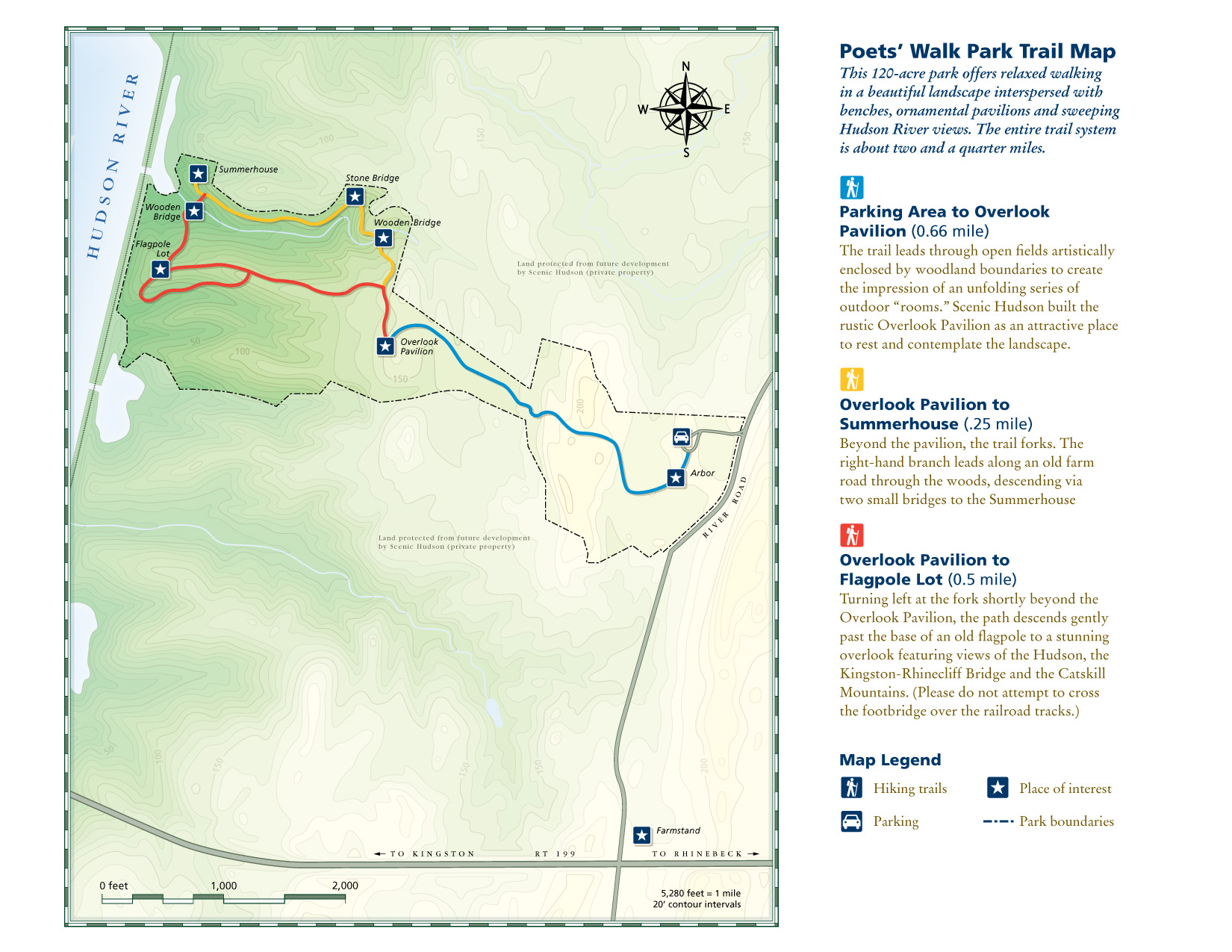
RECENT POSTS
See where I’ve been recently on Instagram and follow @HIKINGFORDONUTS