


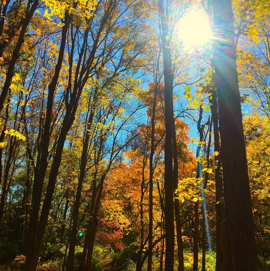
Hancock Brook Trail, Waterbury, CT
Spring weather is finally upon us. As summer approaches, I look forward to finding new hiking trails. I came across Hancock Brook on Instagram and the hike surprised me. And, no it's not closed. Read up on my advice to make sure you complete this trail!


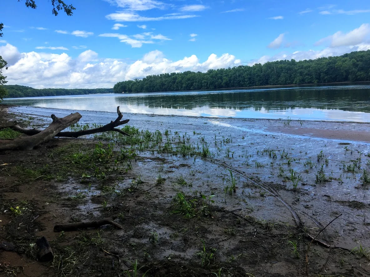
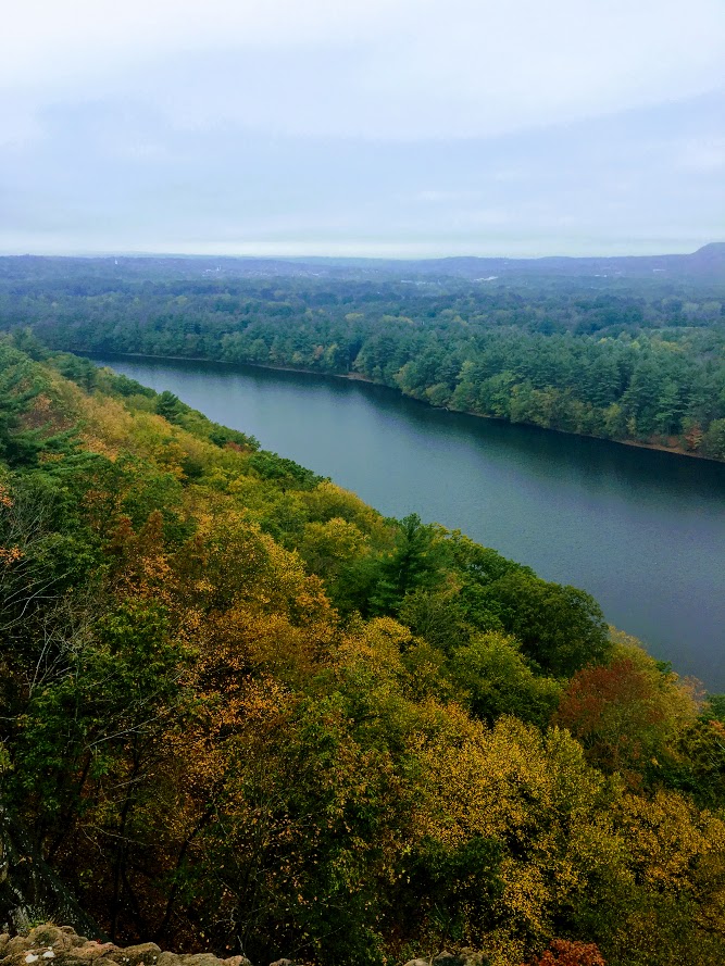
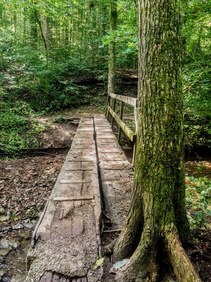
It has been a long, very long winter in the Northeast. The weather finally felt like spring and that means it was time to find some new trails to hike. I came across the Hancock Brook Trail in Waterbury, CT on Instagram from some fellow CT hikers I follow. I never heard of it and the views looked cool. However, my research displayed this trail was closed including sites like Alltrails. After seeing recent posts and finding one actual site with directions on this trail, I felt comfortable enough to give it a go. And, I can confirm the trail is NOT closed. People are giving up too easily. Yes, there is a rotted bridge but the trail can be accessed elsewhere. For directions, plug into your GPS: Sheffield St., Waterbury, CT, 060704. Drive all the way down until you hit the quarry and there is a small parking lot to your right.
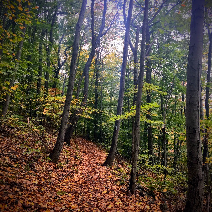
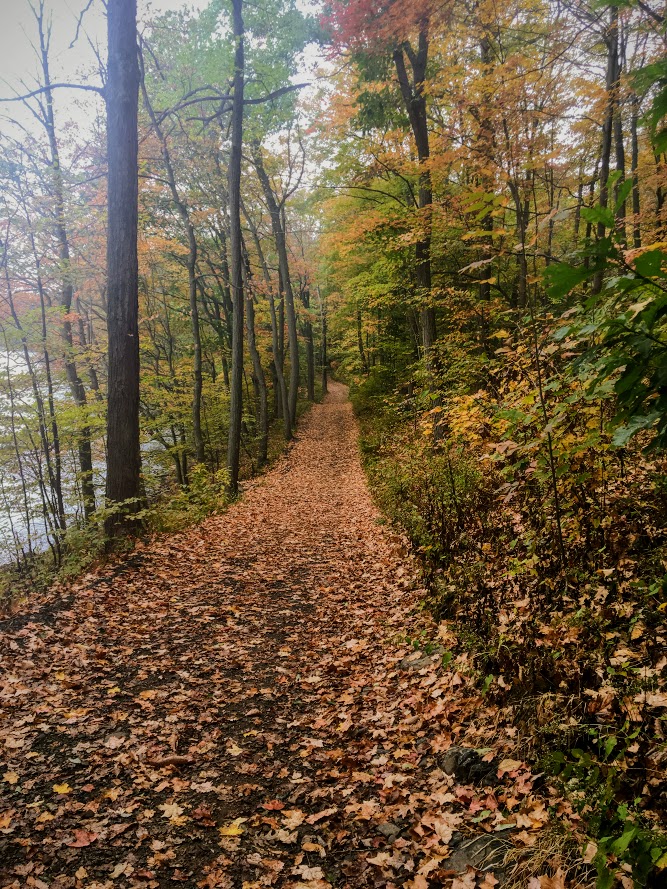
The Hancock Brook Trail is a blue-blaze trail along the edge of the Mattatuck State Forest. This hike is a 2.8 mile loop. The terrain does get quite rocky, which includes steep uphill and downhill portions and some climbing. The trail was covered in leaves on this day and was quite slippery because of that. I would consider this a moderately difficult hike for the average hiker.

Onto to the infamous bridge I kept reading about. Ignore the bridge.

From the parking area, you will start walking up the side of the quarry and look for the first Blue marker. Upon entering the woods, the trail splits and the trail to the right with one blue marker will take you along Hancock Brook. The first half mile or so will give views of the stream and its rapids. The trail is fairly narrow and gets unpleasant as you reach the inclines where the bushes have grown into the trail.


You will reach a spot in the trail where you hear lots of trucks and work on the quarry. There will be a sign to stay on the blazed trail on a tree with the Blue marker.

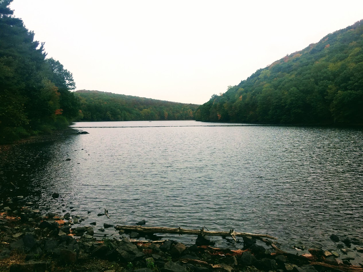
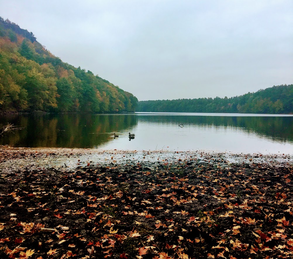
Continue this direction and go straight. This is a tricky part of the trail. The markings are not great until you reach the peak. You will want to veer right but that will take you the wrong way. There is a like a raised branch signaling not to go this way. If not, you will reach a small pond and you will see a very sketchy trailer. Do not go there. That is not part of the trail. You will be too close for comfort. Turn around. I just envisioned all the crazy TV shows I saw with a crazy dude coming out of a trailer and chasing me.

If you went the right way, you will reach the pond and see the trailer across far enough away. You need to make an abrupt left into the woods to start the incline. Once you do not see blue markings, stop and just turn around. We walked by it as well. I took pictures for guidance. The blue marker was covered by trees.
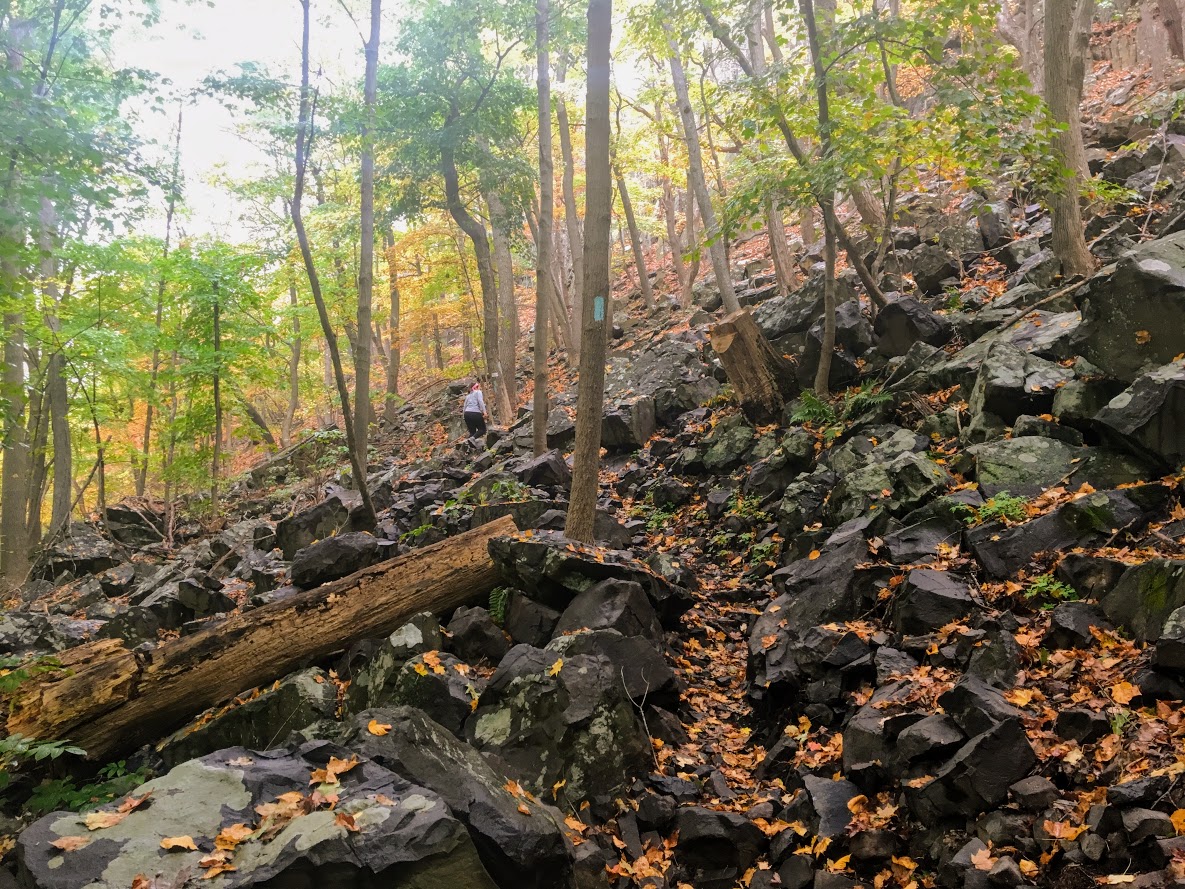
The trail will get tougher at this stage as you enter a pine forest. There is a mini pond with a bunch of trees down as you get closer to the ascend uphill. Keep an eye out for the blue markings. They are a little too far apart in this area. Once you pass this pond, the steep uphill will begin and there will be some switchbacks.

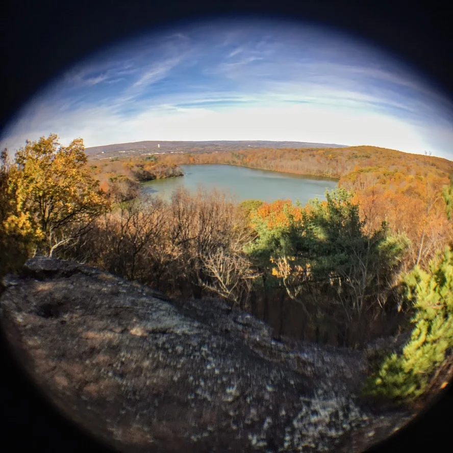
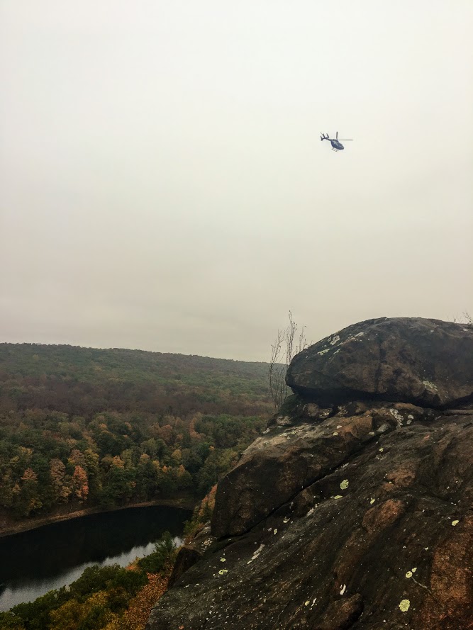
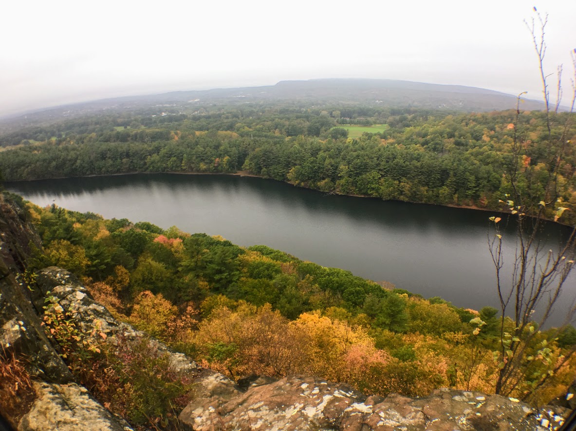
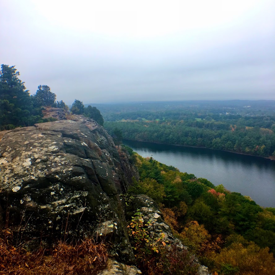
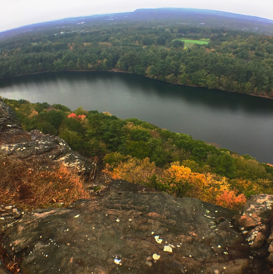
This tough stretch will be worth it as you will reach a beautiful lookout spot for views. The rock formation is called Lion Head and is the peak at 660 feet. This is a great spot to stop and soak in nature. Have a snack and fuel up on water. Maybe eat a donut.


The climb down was tough at first but got pretty easy as we kept going. And, the trail markings were way better. The spots where they were too far apart, I suggest going the way that made sense and you will find them. You will pass a few more lookout points to enjoy more views along the way.


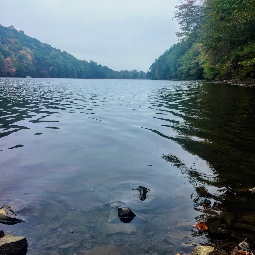
At the end of trail, there will be a steep downhill section before you reach the quarry where you started. And, somehow we completely missed the waterfall coming in, or the water started to come down from melting while we hiked. Before we left, we took a closer look at what is called Hancock Cascades. This was to the left at the end of the final descend.


This was a surprisingly good hike. This took us about 2 hours and that is with stopping for 20 minutes. I don’t think I would have found it without Instagram. The hike was fun and didn’t take too much time. I would just be careful of the markers. There were times where it was lacking and you really had to keep an eye out. And, stay away from the Breaking Bad looking trailer!
Trail Review:
Hancock Brook Trail, Waterbury, CT (2.8m): 3 out of 5


HIKING FOR DONUTS
A blog for the outdoors foodie enthusiast
Hi, I’m Mark. I live in Connecticut. I take new trips every chance I get. A good trip has a great hike, great food, and something fun to do. My goal is to search out new trips and share them to inspire others to try something new and exciting.
If you are looking for posts in a particular place, search by city or state here.
EXPLORE OTHER POSTS IN THE ARCHIVE
RECOMMENDED POSTS

MOST RECENT POSTS


See where I have been recently on Instagram. Follow @HIKINGFORDONUTS


Hiking the Rockies: Hallett Peak
If you want to try a challenging hike in Colorado, this post is for you. Check out my Hallett Peak hike and advice not getting lost like me!
In the summer of 2013, I decided to take my first trip to Colorado. I was looking for a new destination to explore and adventure. As far as in the U.S., Colorado was at the top of my list. My buddy Corey devised a plan as per usual, which was all it took for me to say yes. We had never been there and the Rocky Mountains were calling our names.
Three months later we landed in Denver and got right on the hiking trails. At the time, we were younger and in better shape so the altitude didn’t affect us too much. With that said, my conditioning was tested on a challenging, mammoth hike, which at the time was highest elevation I had ever been. And, that trail was Hallett Peak.

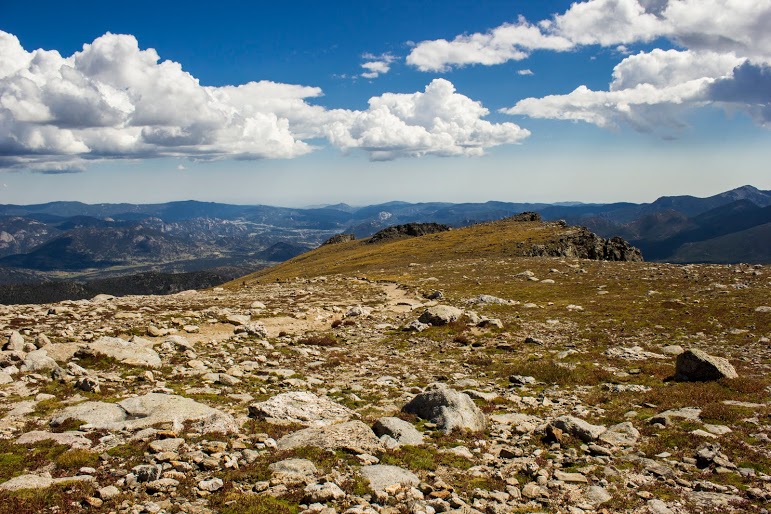
Hallett Peak lies along the Continental Divide, the point at which water on the western slope flows towards the Pacific Ocean, and water on the eastern slope flows towards the Atlantic Ocean. Hallet Peak stands at 12,713 feet tall. The highest mountain I have hiked up to this point was Mount Washburn in Yellowstone a few months earlier at over 7,000 feet.
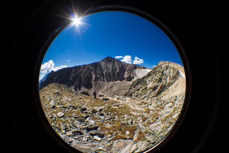

The hike begins at the Bear Lake Trailhead, and then follows the signs toward Flattop Peak. Most of the hike is above tree line as it switchbacks up the side of Flattop Mountain. The trail had some steep uphill moments. The altitude was starting to get to me as we got higher. I had to stop every so often and catch my breathe. This gave us a chance to see wildlife, mostly little critters, and the abundant wildflowers along the way. Once you arrive at the summit you must identify the unnamed trail leading south toward Hallet Peak. Be careful, as we got lost and added an additional two miles by missing the trail. Although, the views were amazing so adding more to the hike was a bonus. Around the top of the of Tyndall Glacier, the last half mile of the hike involves ascending up the slippery, rocky slopes toward the summit by connecting short trails marked by cairns. We reached the top as storm clouds began to appear.

Love me some cairns.


Before we headed back to beat any possible storms, we ate lunch and drank some well-deserved beers. The total round trip for this trail is 10.3 miles. With our detour, we trekked just over 12 miles. This trail was absolutely awesome with remarkable views. The trail was really, really tough but I would do it all over again. I definitely felt like I was on top of the Rockies. John Denver was not full of……


HIKING FOR DONUTS
A blog for the outdoors foodie enthusiast
Hi, I’m Mark. I live in Connecticut. I take new trips every chance I get. A good trip has a great hike, great food, and something fun to do. My goal is to search out new trips and share them to inspire others to try something new and exciting.
If you are looking for posts in a particular place, search by city or state here.
EXPLORE OTHER POSTS IN THE ARCHIVE
RECOMMENDED POSTS


MOST RECENT POSTS
See where I have been recently on Instagram. Follow @HIKINGFORDONUTS
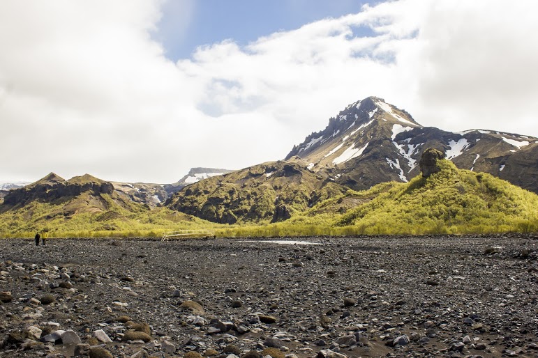
Hiking in Iceland: Thórsmörk
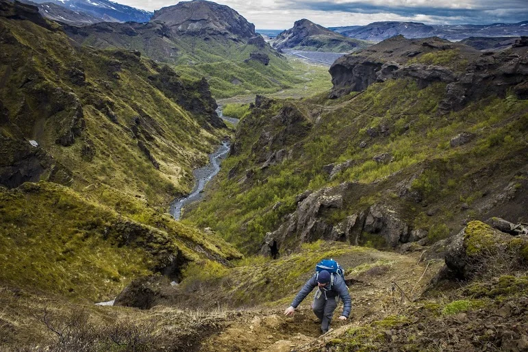
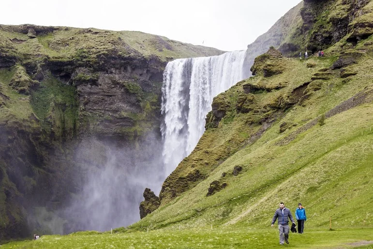
In 2010, a Volcano erupted in Southern Iceland. This eruption occurred near a popular hiking path from Skógar to Thórsmörk. Luckily, during my trip, the hiking route was opened. The terrain was difficult and cut the hike short but the views along the way were mesmerizing.
On my eight hour flight to Iceland, there was a lot of time to spare. The movie selection wasn’t great. And, then I saw the film, “The Secret Life of Walter Mitty.” Ben Stiller was in it and I figured it had to be decent. I started watching and realized, hey this is in Iceland. I turned to Corey and was like did you know this? And, he responded, yes I told you 10 times about this movie…..I’m not a good listener. As I watched, I would pause the movie every 20 minutes and say is this where we are going?!?!?! There was one scene where a volcano erupted and had Ben Stiller’s character running for cover. Pause again, I turn to Corey, are we going to see this? And he said, uh, we are hiking this. Oh snap. It’s about to go down. Eyjafjallajökull, you read that right, is a small ice cap located in Southern Iceland. In March, 2010, thousands of earthquakes were detected and caused an eruption in Fimmvörðuháls, the area of a popular hiking route from Skógar to Thórsmörk, which was then proceeded by a much more violent eruption at the top of the volcano, beneath the glacier. This second eruption caused massive floodwater to pour down the side of the volcano. Over 800 people were evacuated and Iceland’s Glacial Lagoons were destroyed. This even caused a stir with air traffic in Europe, which was paused for numerous days. Four years later, the devastation was still visible and lava was still smoking on the side of the volcano. As luck would have it, the hiking trails were opened and hikers can travel the route and take in these new views. And, that is what we planned to do if the weather permitted. We booked a night at the Volcano Huts in Thórsmörk, which was an awesome experience even if we didn’t attempt a hike. We had to take an hour long bus ride into Thórsmörk, crossing streams and passing glacier tongues.

The initial plan was to hike the entire trail close to 16 miles, see some lava. As we got closer, we realized there was no way we could safely make it to the Fimmvörðuháls pass. However, we like exploration and adventure. We decided to continue with our bold plan until we just couldn’t go on. Try to see as much as we can. You never know if you will be back.
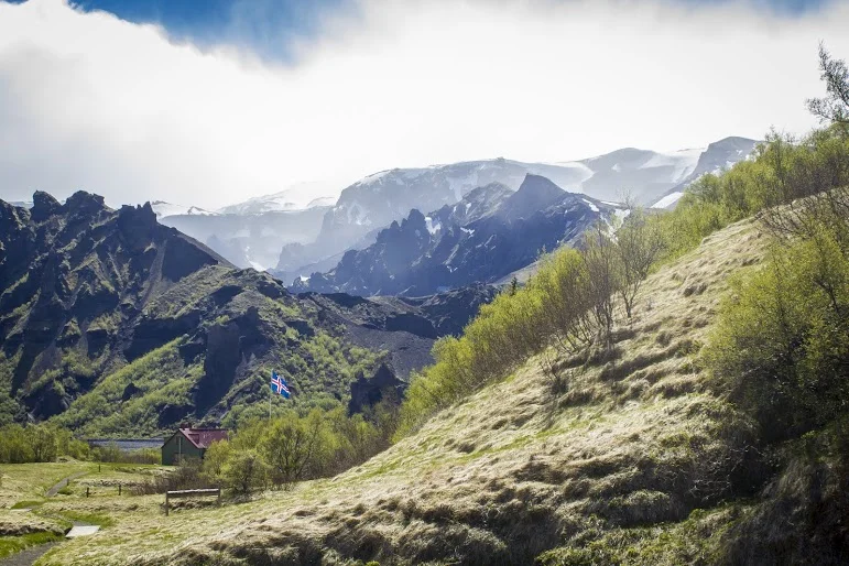


After speaking with the guide at the hut, we started our trek onto the beginning of the Fimmvörðuháls pass. The trail began with small brooks through a woodsy path. And, just like that we were exposed to a large field and a visual of glacial capped mountains. The next section of the hike was an enormous, rocky flood plain that we had to cross. There was a mobile bridge positioned at the end of the rocky terrain where the river was currently running through. We made our way across the bridge to the base of the snowy mountain on the opposite end of the valley where we started. We began our accent up the mountain and the terrain quickly transformed as snow began to appear. We crossed paths with our first hiker of the day heading the opposite direction. We made sure we were going in the right direction and were informed that the terrain was going to get dicey. And, there were currently blizzard conditions farther up the trail. We had packed for the worst, tents, extra clothing and food, so we continued on. Goals of lava steaming were still in sight.

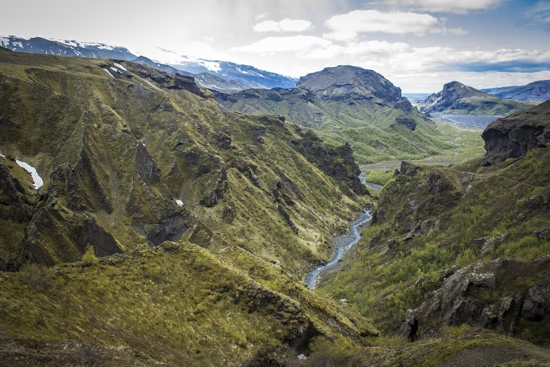


As we made our way up the side of the mountain, patches of snow turned into thick layers of snow. And, this is where things got interesting. There weren’t any prior footprints to just step in as no one had dared to travel this far. We had to carefully, side step along the along the ridge line. Or else we were going sledding down the side of the mountain and……goodbye. We passed multiple sections of pure snow/ice drifts on this very steep mountain slope. Definitely one of the times I had some actual fear and wanting to maybe just turn around. But, persistence always prevails. Eventually we reached the top of the ridge trail and proceeded onto flat land covered in volcanic ash, mud, and rocks. We continued to trek across the this plain until we reached the cliff on the opposite side of the mountain.
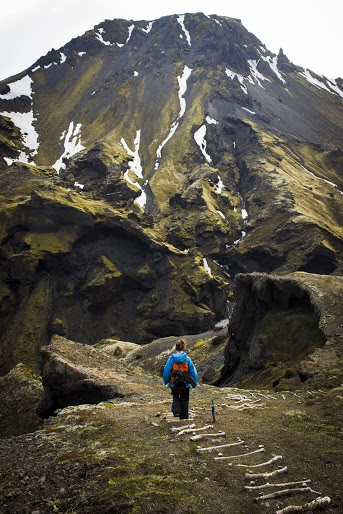


At this point, the remainder of the trail looked too risky. As we would need to descend down between the mountains and ascend back up. After what we just did along the ridge line, we called it at this point. We regrouped and chomped on treats to refuel. Then, Corey noticed smoke on the side of the mountain and realized that it was cooling lava. We have attained our goal of seeking lava! The scene was remarkable. The experience was epic. This is what HikingforDonuts is all about. Push yourself, go beyond your comfort zone, and discover what’s out there. .....Then eat a donut ☺.


HIKING FOR DONUTS
A blog for the outdoors foodie enthusiast
Hi, I’m Mark. I live in Connecticut. I take new trips every chance I get. A good trip has a great hike, great food, and something fun to do. My goal is to search out new trips and share them to inspire others to try something new and exciting.
If you are looking for posts in a particular place, search by city or state here.
EXPLORE OTHER POSTS IN THE ARCHIVE
RECOMMENDED POSTS

MOST RECENT POSTS
See where I have been recently on Instagram. Follow @HIKINGFORDONUTS

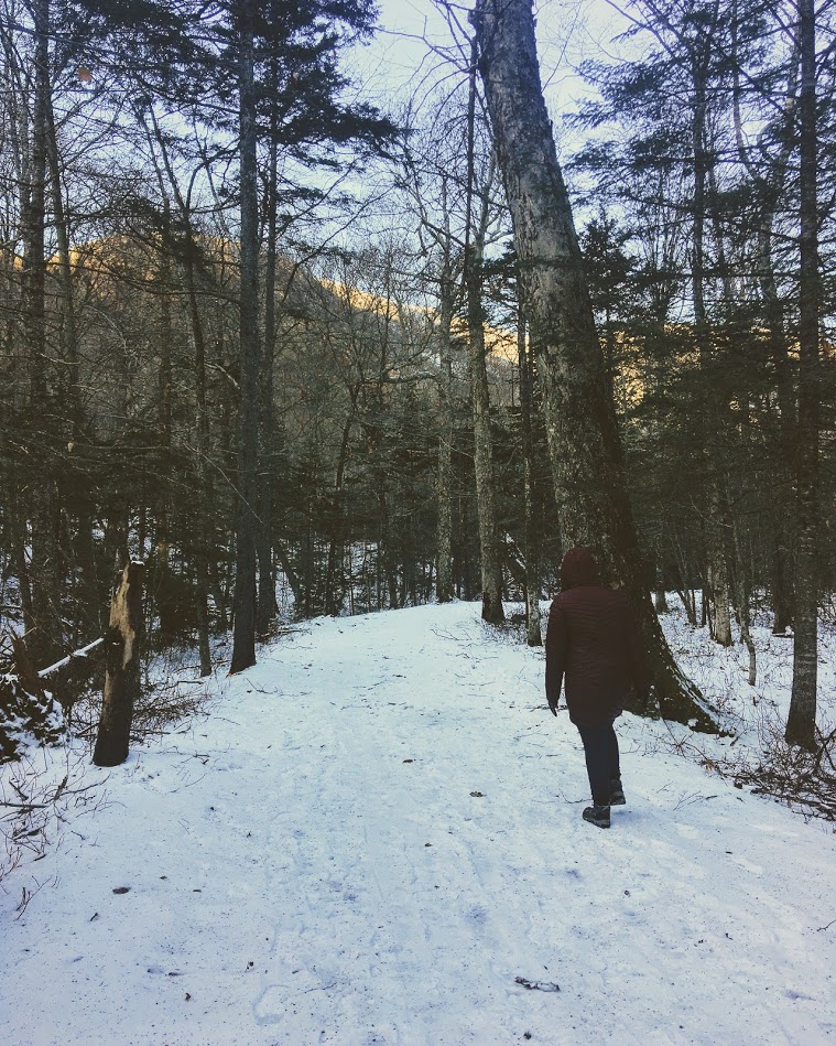
Winter is here...in the Basin
Fun weekend back in New Hampshire. This time I made a trip back to Franconia Notch State Park and hiked to the Basin. A pretty, cool spot that is very accessible.

It was time for another trek up to New Hampshire. After a few brewery stops, we finally made it up to my friend’s house. And, there was snow on the ground! Even though weather was in 20s, we still wanted to enjoy the outdoors New Hampshire has to offer. My friend decided The Basin in Franconia Notch State Park would be a good “jaunt” for the 5 of us and our friend’s puppy. The trail and parking lot is right off the highway off I-93. We parked at the visitor center and just hopped on the trail towards the Basin. This trail was mostly flat but due to the snow and ice, it was more tricky. In nicer weather, this is a very easy walk, paved most of the way and offers handicapped accessible viewing as well. We walked over a few bridges and eventually came across some cool waterfalls. We then made our way to The Basin, which offers rushing waters that has eroded the rock into a smooth, circular cave-like formation. After seeing that we walked a little further before the Pemi Trail and started our way back to the cars. Our hike was roughly 3.5 miles. Even though it was quite cold, it was a beautiful day to be outside. We enjoyed our mascot keeping us on our toes. Always fun to see a pup’s first time in the snow. Another reminder to get out there and enjoy time with friends!


HIKING FOR DONUTS
A blog for the outdoors foodie enthusiast
Hi, I’m Mark. I live in Connecticut. I take new trips every chance I get. A good trip has a great hike, great food, and something fun to do. My goal is to search out new trips and share them to inspire others to try something new and exciting.
If you are looking for posts in a particular place, search by city or state here.
EXPLORE OTHER POSTS IN THE ARCHIVE
RECOMMENDED POSTS


MOST RECENT POSTS
See where I have been recently on Instagram. Follow @HIKINGFORDONUTS

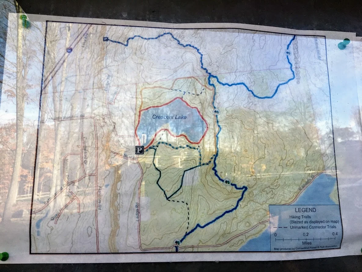
Sunset Rock State Park, Crescent Lake, Southington, CT
Check out the Crescent Lake trail in Southington, CT. This was a confusing trail but well worth the views. Enjoy!
Trail Description: Sunset Rock State Park offers a scenic hike around Crescent Lake that connects to the Metacomet Trail.
Trail Info:
Where: Southington, CT Distance 3.2 miles (2-2.5 hrs) Difficulty: Easy to Moderate Trail Type: Loop Features: Views, Lake, Water
How to get there:
Address to GPS: 357 Shuttle Meadow Rd, Plainville, CT 06062. Parking lot is easy to find.
Hiking Tips
Three trails to choose from. The Blue to Orange trail takes you above the lake and is rockier and steeper. Much better views.
Be mindful if you lose the trail markings or end up on a different trail. There is a lack of trail markings. And, some confusing areas where trail markers change colors.
The Hike
On this brisk fall weekend, we decided to hike the Crescent Lake Trail in Southington, CT. This is one of those trails that there isn’t the best information online and it is poorly marked. I will do my best explaining but my advice is always have the map handy and make sure someone is good at directions!
The parking lot is easy to get to, it is off Shuttle Meadow Road. Once you park you will see the lake right in front of you and potentially some people fishing. There are 3 trails. The Red trail is the lower level trail which is mostly flat. This is to your far left from the lot. This is roughly 2m. The blue -orange trails takes you the upper levels to get good views above the lake and this is rockier and steeper. This trail is to your right from the lot. This is about 3.2m and this connects to the Red at the end once you descend down. There is also a green trail, but not sure where that takes you. It appeared to be just a woodsy hike.
We got lost a few times but Nichole is really good with reading trail maps. The issue is lack of markings/incorrect markings. And, the Metacomet Trail connects so you have to be very careful when the colors change. We took the upper trail followed blue-orange markers until we saw just orange then to red. There we were some tough sections where you could choose 3 directions but there are big orange arrows on trees along the way so be mindful of those. There is also an intersection where you see trail arrows for the Metacomet at the top, keep going toward the blue orange and you will pass a camp fire pit. Minus the confusion, it was a cool hike and the view was awesome from the top. I could of took pictures for an hour….luckily, Nichole stopped me. The upper trail I would suggest hiking boots. It was a moderate hike for beginner to intermediate. Some of the inclines got our hearts beating and needing some water. I think this would be a good spot to snowshoe. I hope to keep the fall hikes going. Another local spot in the books, glad we decided to try it even though the reviews were suspect.
Review:
Cresent Lake Trail, 3.2m (Southington, CT): 4 out of 5


HIKING FOR DONUTS
A blog for the outdoors foodie enthusiast
Hi, I’m Mark. I live in Connecticut. I take new trips every chance I get. A good trip has a great hike, great food, and something fun to do. My goal is to search out new trips and share them to inspire others to try something new and exciting.
If you are looking for posts in a particular place, search by city or state here.
EXPLORE OTHER POSTS IN THE ARCHIVE
RECOMMENDED POSTS

MOST RECENT POSTS
See where I have been recently on Instagram. Follow @HIKINGFORDONUTS

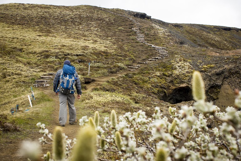
Mine Hill Preserve Trail, Roxbury, CT
More fun fall hikes in CT! The fall colors are really showing now. I decided to hike a new trail this time. I chose Mine Hill Reserve Trail in Roxbury, CT. The trail was unique and offered cool historic features. Check it out for great leaf peeper pics.
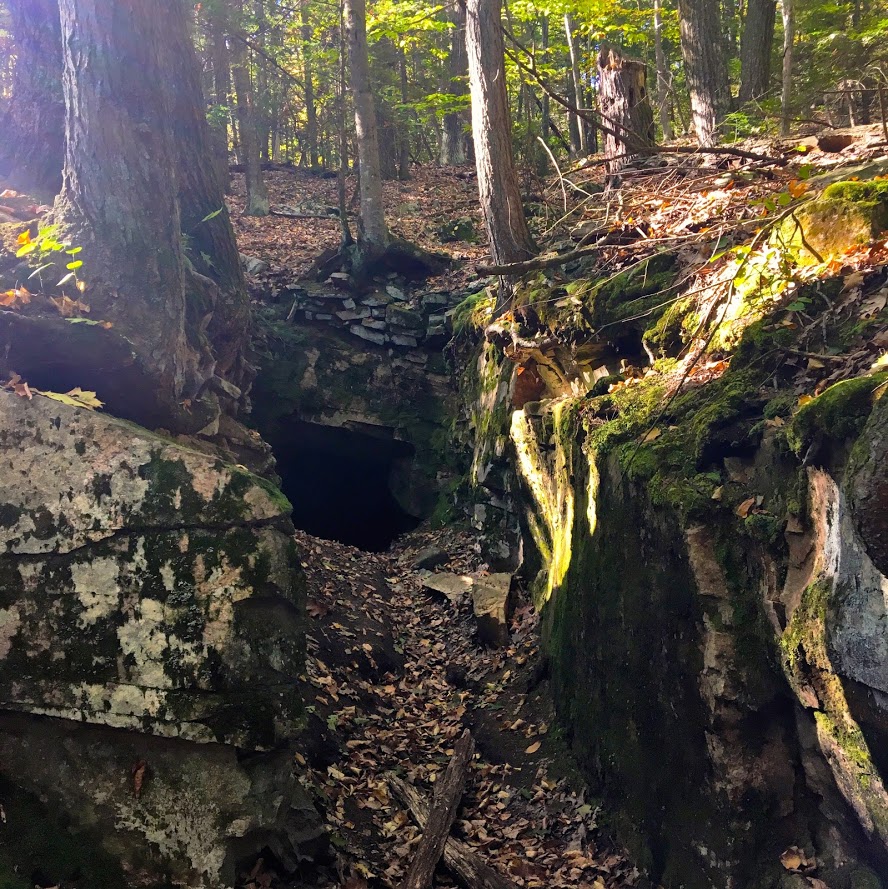
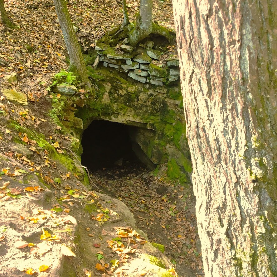
Trail Description: The Mine Hill Preserve trail is part of the Roxbury Land Trust as a national historical landmark. Venturing on this trail will take you through scenic woodlands, rocky terrain, mine tunnels, bat caves, and old furnace structures from the 19th century.
Trail Info:
Where: Roxbury, CT
Distance 3.6 miles (2 hrs)
Difficulty: Easy to Moderate
Trail Type: Loop
Features: Water, Bat Caves, Quarry, Bridge, Mine Tunnels, Old Furnaces
How to get there:
6 Mine Hill Road, Roxbury, CT 06783
The GPS lost signal as I got on Mine Hill Road, but just follow the signs on the gravel road to the parking lot.
Hiking Tips
Download a map of the trail, http://www.roxburylandtrust.org/MapMineHill.pdf.
Veer left to start with the more difficult section toward the Donkey Trail. The latter part of the trail is more like a brisk nature walk on flat ground.
The Hike
This past weekend’s hike was recommended by a friend. Nichole and I took a ride out to Roxbury, CT to the Mine Hill Preserve Trail. This trail offers some unique features where you will see various mines and old furnace stoves from the 19th century. This is definitely off the beaten path. There is a very small parking lot where the trail heads start. There are only two trails here. There is a 3.6m loop (blue trail- Mine Hill Preserve) and an additional 2m loop can be added (red trail – Carter Reserve). Due to time constraints, we just did the blue trail loop. The maps online for this area are very helpful too. I would suggest downloading here prior to the hike. The trails are a short walk from the parking lot. If you really wanted to just see the old furnace structures, this is only a 10 minute walk from the start if you veer right. Prior to hiking, I read the veering to the left would get the difficult portion of the hike done and that is what we chose.

In this direction, you pass a small pond to your right.

The main loop ascends up the Donkey Trail and here you will pass two mine tunnels.


The terrain was pretty interesting and varied. This side of the loop was by far the most challenging. It was very rocky and had some steep uphill areas. As you keep hiking , you will cross paths with multiple bat cages that serve as entry ways for the caves inside them.


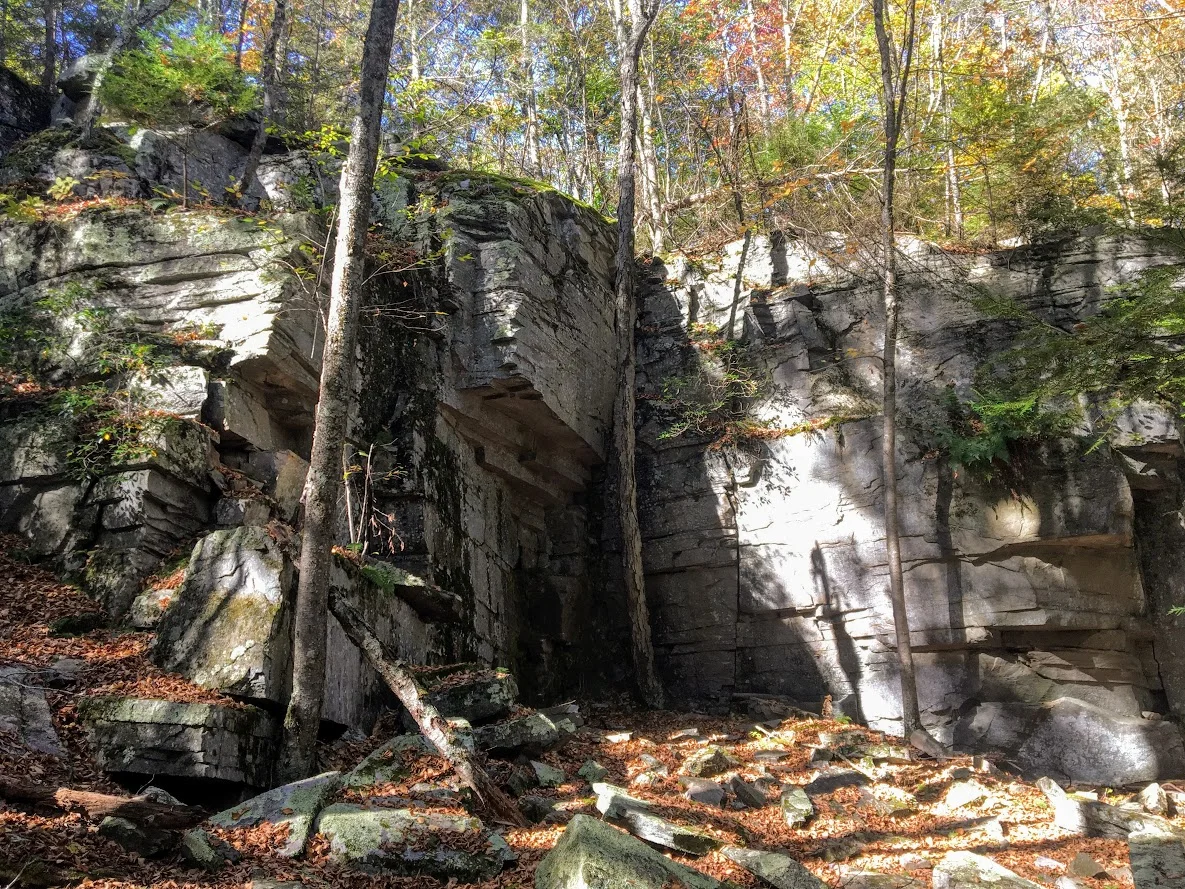
The trails begins to descend and you will meet at the Old Quarry bridge which joins a dirt road that will lead you to the other side of the loop. The other side of the loop was more of a nature path. It was flat the whole way, roughly 1.5m. This was less interesting until the end where you will find the old forge site. The fall colors kept me attentive along the way.


Overall, the historic points of the trail offered a different features you don’t get on hikes generally. The trail was very maintained and marked well. The hike would be good for anyone beginner to advanced. I would recommend hiking boots since the terrain can be rocky. The loop didn’t take us too long, about 1 hr 45 min. Next time, I would leave more time and add the additional 2m loop. Pretty good recommendation!
Review:
Mine Hill Reserve Trail, 3.6m (Roxbury, CT): 3.5 out of 5

HIKING FOR DONUTS
A blog for the outdoors foodie enthusiast
Hi, I’m Mark. I live in Connecticut. I take new trips every chance I get. A good trip has a great hike, great food, and something fun to do. My goal is to search out new trips and share them to inspire others to try something new and exciting.
If you are looking for posts in a particular place, search by city or state here.
EXPLORE OTHER POSTS IN THE ARCHIVE
RECOMMENDED POSTS


MOST RECENT POSTS
See where I have been recently on Instagram. Follow @HIKINGFORDONUTS

Chauncey Peak Trail, Giuffrida Park, Meriden, CT
It is leaf peeper season here in the Northeast. There is no better time to go hiking than in the fall. I am going to attempt as many hikes as I can get in. Here's the first of many! And, one of my favorites.
Trail Description: Located in Guiffrida Park, the Chauncey Peak Trail offers a scenic hike with beautiful ridge line views of Bradley Hubbard Reservoir.
Trail Info:
Where: Guiffrida Park, Meriden, CT Distance: 2.8 miles (2-2.5 hrs) Difficulty: Moderate Trail Type: Loop Features: Views, Reservoir, Lake, Peak
How to get there:
This is fairly easy. Just GPS Guiffrida Park and the address should be 800 Westfield Rd, Meriden, CT 06450. Once you pull in, you will see the parking lot.
Hiking Tips
Start the hike to the right of the parking lot into the forest. Much easier route going up and down.
The trail has been updated and re-routed. Be sure to follow the blue trail around Chauncey Peak and past the landfill. Look for the Blue markings.
There are many great views from the ridge line, be sure to take them all in.
The Hike
It is officially fall. It is chilly in the morning, the leaves are changing, and it is getting darker out earlier. Time to get out there and be a leaf peeper. Sounds kind of sketchy…..But seriously, fall hikes are the best. I slacked a little bit this summer with hiking, but I intend to take advantage of the fall weather.
For my first fall hike, I chose the Chauncey Peak Trail at Giuffrida Park in Meriden, CT. This is my favorite hike in the Hartford area, hands down. I have hiked this trail multiple times and I enjoy it just as much each time. This is a very fun hike with great scenic views and a variety of terrains overlooking Bradley Hubbard Reservoir. Unfortunately, due to the fog on this day, it was tough to get that view in. I like to start the hike veering to the right under the trees into the woods on the Blue trail. You will get the strenuous part of the hike done in the beginning. You will immediately be on the incline ascent up the peak, this will be steep and rocky stretch. This won’t last too long. Once you get to the top, you will keep following the blue trail and this will bring you to the ridge line for great panoramic views. Once you are done taking hundreds of pictures, you will descend down until you meet a footbridge that takes you to the bottom of the reservoir. You will follow out the blue trail to the white trail along the water’s edge to the parking lot. This part will be flat and serves as a nice cool down.
The trail is well marked. They are taking great care of it. When I hiked this originally I got lost but since then the markings have greatly improved.I would consider this a moderate hike. You need hiking boots. Depending on the weather, it can be very slippery. I was slipping on the leaves and loose rocks myself due to some wetness. I finished hiking under 2 hrs. If you want a nice short day hiking with challenge and rewarding views, I highly recommend this trail.
Review:
Chauncey Peak Trail, 2.8m (Meriden, CT): 4.5 out of 5

HIKING FOR DONUTS
A blog for the outdoors foodie enthusiast
Hi, I’m Mark. I live in Connecticut. I take new trips every chance I get. A good trip has a great hike, great food, and something fun to do. My goal is to search out new trips and share them to inspire others to try something new and exciting.
If you are looking for posts in a particular place, search by city or state here.
EXPLORE OTHER POSTS IN THE ARCHIVE
RECOMMENDED POSTS
MOST RECENT POSTS
See where I have been recently on Instagram. Follow @HIKINGFORDONUTS
Honky Tonk Hiking in Nashville, TN!
Spent the long labor day weekend hiking in Nashville, TN! Aside from bars, music & food, I was able to enjoy some great outdoor activities. Got a hike in and explored a lake. Nashville hikes.

It has been a busy month….and a very busy summer. The last trip on my agenda for the summer was Nashville, TN. I have never been there before and I hear lots of great things. My girlfriend, Nichole, has been there 4 times now. She was tasked with showing me the ropes. Aside from the food and the bars, we made time for some outdoors activities and adventuring. I did some research found some cool parks nearby such as The Warner Parks. We decided to rent a car for the day and made our trek ready to sweat off the beers, biscuits, and hot chicken.
We stayed in downtown Nashville and made the 20 minute drive to Edwin Warner Park first. Here is where we started with a nice refreshing hike. The weather held up for us and was perfect. The park was easy to get to and there is ample parking. There is a nature center for water and bathrooms also.

We decided to take the Harpeth Woods Trail, which was roughly a 2.5 mile loop. There are three trailheads in Edwin Warner Park which access the trail: Owl Hollow, Natchez Trace Trailhead, or the Nature Center Trailhead. We walked further down from the Nature Center and started at the Natchez Trace Trailhead. The Harpeth Woods Trail is the blue trail. The trail is very well marked, all we needed to do is follow the blue arrows. Please note, this is a very popular park. We were there on Labor Day but there isn’t a lot of options in the metro Nashville area.


This particular hike was a typical woodsy trail. No scenic views but a good hike. There were some cool rocks formations and bridges to cross. There was a small part of the hike that was a nice incline but that was maybe 1/10 of a mile. In my opinion, this was an easy hike based on my abilities. I wore Nike training shoes and have a bum ankle still. However, I can see this being moderate for others. I did my best to take unique pics.


After the hike, we decided to venture to Percy Warner Park as well since it was only a mile away. At this location, there is a cool landmark known as the Percy Warner Park Stairs. This gives you a nice burn going up and a view from the top from where the trail heads start.


The last stop was Radnor Lake. This location was only 20 minutes from the Warner Parks. Since we had the rental car, we figured we would try to get in as much as possible. This area was very, very busy and parking was an issue. There are two parking entrances. One lot was completely full. However, it is was a really nice ride to both entrances. We got to see pretty nice houses and scenic views. Nichole even questioned some houses, "I wonder if someone famous lives here." Once we got a parking space, we just quickly perused the lake and went on the bridge to see some views. It’s cool for the area and I understand the traffic. This sums up our labor day in Nashville. I didn’t anticipate getting this much outdoors in so close to the city.


HIKING FOR DONUTS
A blog for the outdoors foodie enthusiast
Hi, I’m Mark. I live in Connecticut. I take new trips every chance I get. A good trip has a great hike, great food, and something fun to do. My goal is to search out new trips and share them to inspire others to try something new and exciting.
If you are looking for posts in a particular place, search by city or state here.
EXPLORE OTHER POSTS IN THE ARCHIVE
RECOMMENDED POSTS
MOST RECENT POSTS
See where I have been recently on Instagram. Follow @HIKINGFORDONUTS

Mount Lafayette, New Hampshire
The White Mountains in New Hampshire is one of my favorites areas to hike. On this day, I conquered Mount Lafayette. What a hike!
Trail Description: Mount Lafayette is the highest peak in the Franconia Ridge at 5,260 feet. The summit offers amazing 360 views of the Pemigewasset Wilderness Area.
Trail Info:
Where: Lincoln, NH Distance: 8.0 miles (7-8 hrs) Difficulty: Hard Trail Type: Out and Back Features: Views, Peaks, Mountains, Greenleaf Hut
How to get there:
The parking lot for this hike is located in Franconia Notch on I-93. You can park on either side of the Interstate. Traveling north, you can park in the trailhead lot for the Falling Waters and Old Bridle Path trails. Traveling south, take exit 34b at Lafayette Place Campground. Follow the foot tunnel that goes under I-93 to the parking lot the opposite side of the highway to start the trail.
Hiking Tips
Bring lots of water, wear your best boots, hiking poles, and pack snacks.
Suggest doing the loop version of this hike along the Franconia Ridge trail to see Mount Lincoln and Little Haystack for more views.
Due to the popularity, the trail can be very crowded.
The White Mountains in New Hampshire are one of my favorite areas to visit and go hiking. It is one of the coolest areas in the Northeast and makes me feel like I’m in a different part of Unites States. It has a pacific coast mountainous look. I try to do a few hikes a year in New Hampshire. A large group of my friends rent houses in the area a few times a year to hang out. Even better, my best friend recently purchased a vacation home close to this area, about 15 minutes from Franconia. I bought new hiking boots and figured I wanted to do a fun, difficult hike in the White Mountains. More specifically, a hike I have not done. The one hike I really wanted to do was the Mount Lafayette summit. My friend said it was “easier” than Mount Washington but still hard. Lies. It was really freakin’ difficult. And, a terrible decision to wear new boots.
By the time we got there, it was near 11am and my friend suggested shaving a mile off the hike by skipping the trails where you would see Mt Lincoln and Little Haystack. I was against this decision but I was overruled. Disclaimer: This is a very popular hike. One of the best New England has to offer. There were cars lined up the side of the roads and the lots were full. This created a very tight hiking path. There was a lot of stopping and waiting for other hikers as the paths can be very narrow. For a summer hike, the weather was perfect, mid-70s and the skies were sunny and clear. We made our way to the trail which begins to the right of the information sign (there are bathrooms as well). Most hikers choose to go up the Falling Waters Trail as it is recommended by the trail guides. Another reason we chose to go up the Old Bridle Path as this was less crowded. After a good 1.5 miles into the trail you will seeing some great scenic views.


This path is 2.9 miles that will lead you to the AMC Greenleaf Hut. The hut is where hikers can use the restroom, eat, and enjoy the views. The hut also has some lodging options for those hikers who choose to do so.

From here, you will begin the rocky assent for another 1.1 miles to the top of Mount Lafayette, about 5,260 feet above elevation. We came down the same way we went up. The total hike was 8 miles.


Unfortunately for myself, the trail down wasn’t too fun as I sprained my ankle pretty bad. This hike is no joke and I would recommend using caution. For the inexperienced, I would prepare for a 8-9 hour hike. With my ankle issue, the hike took us over 8 hours. I would suggest using hiking poles, good boots and bring lots of H2O. I saw a couple wearing sandals. I can’t tell you how bad an idea that is. You will keep asking yourself, this isn’t a mile, 2, 3, 4? Given the incline, the hike will feel a lot longer. It was well worth it. The views are awesome. It leaves a very good sense of accomplishment. I will definitely go back another year to complete the Franconia Ridge Trail.

Review:
Bridle Path to Mount Lafayette Summit Trail (Franconia, NH, 8 miles): 5 out of 5!!!

HIKING FOR DONUTS
A blog for the outdoors, foodie enthusiast
Hi, I’m Mark. I live In Connecticut. I take new trips every chance I get. A good trip has a great hike, great food, and something fun to do. My goal is to search out new trips and share them to inspire others to try something new and exciting.
If you are trying to find posts about a particular place, search by city or state here.
Explore other posts in the archive
RECOMMENDED POSTS
RECENT POSTS
See where I’ve been recently on Instagram. Follow @HIKINGFORDONUTS.
First Trip to the Adirondacks: Hiking in Upstate New York
My first trip hiking in the Adirondacks in Upstate New York. Adirondacks Travel Guide. I was able to wake up to Paradox Lake each day, hike Mount Severance, and check out Paradox Brewery. Moderate hike, amazing views along the way!
Trail Description: Planning your first trip to the Adirondacks? Discover beginner-friendly hikes, breathtaking views, and tips for exploring New York's stunning wilderness.
Trail Info:
Where: Schroon Lake, NY Click here for directions. Distance: 2.4 miles Difficulty: Moderate Trail Type: Out and Back Trail Features: Picturesque views of Schroon Lake and Pharaoah Lake Wilderness
How to get there:
The parking lot for the hike was easy to find. It is right off State Route 9. However, my gps got confused and made us go out of the way. Once parked, the trailhead is right in front of you through the tunnels under the I-87.
Hiking Tips:
Put your name in the Sign In chart once you arrive.
This hike could easily been done in normal gym shoes.
Adirondacks Weekend Travel Guide Recommendation: Mount Severance Hike and Paradox Brewery
The warm weather is finally here to stay in the northeast. Summer of 2017 looks pretty darn good. I have been planning as many trips as my wallet can handle. My weekends are booked up through almost October. There will be many adventures and lots of food. The first real travel this summer was thanks to friends of mine. They have a friend who owns a house on Paradox Lake. It was a good opportunity to check out some hiking in upstate New York. It was my first trip to the Adirondacks. The house was legit right on the lake. We had our own little beach area and dock. The house was pretty remote so there was no internet connection. It is good sometimes to go without the need of checking your phone on social media and enjoy where you are and who you are with. However, the second I had internet it was game on! It was absolutely, awesome views to see the sun rise and see the sun set. I tried to get good pictures, but I always get distracted by food. I couldn’t help it. My friend’s family always goes all out. It was a weekend of relaxing, filet mignons and tasty ribs.
I have never ventured to this part of New York. The Adirondacks has been on my list of areas to see for a while. When I saw the house was nestled in the Adirondacks Park, I quickly said, “I’m in!”. The first night we hung out at the house and settled in. The next day we did some swimming and soaking in the beauty of the lake. The weather was exceptional. Sun was out with a cool breeze. In the afternoon we headed into the town of Schroon Lake, which was about a 10 minute ride. It was a nice little town area full of small businesses such as ice cream shops, restaurants, and stores. Our mission on this afternoon was beer. We researched a local brewery prior to our stay and it turned out pretty good. It was called Paradox Brewery. All of the seating and bar taps were located outside. There was a food truck and corn hole boards. More importantly, the beer was good. They had a selection of 7 different beers consisting of IPAs, Pilsner, Rye Ale, Saisons, Sour and Stout options. They had one cider from another brewery, Awestruck, which was extremely delish. My favorite beers were the Double IPA and surprisingly the Sour. Sours aren't usually my thing but this one was so good I got a growler. The tartness I did taste was the mix of melons, limes, and citrus. It is a kettle sour aptly named "Oats and Gose". The brewery was a good find to have beers and hang out. I would give it a shot if you are in the area.
Paradox Brewery in Schrron Lake, NY.
The last day I was there, I had to get a hike in. There were a handful of hikes within 30 minutes or so of our location. The one that caught my eye was Mount Severance in Schroon Lake, NY. It was only about 10 minutes from the house rental. The parking lot for the hike was easy to find. It is right off State Route 9. However, my gps got confused and made us go out of the way since the beginning of the hike starts under I-87. Once you were parked, the trailhead is right in front of you through the tunnels under the I-87. One thing that stood out to me, there was a sign-in chart for hikers. I have never seen that before and I thought that was a great idea if people were to get lost or injured. For a longer or more strenuous hikes, I would like to see more of these. For this hike, it was very well marked and and a quick trip to the summit. I can see why this is a popular hike. It was roughly 2 .4 miles round trip and the summit offers picturesque views of Schroon Lake and Pharaoah Lake Wilderness. The terrain wasn’t bad although we got caught in a little rain storm. There were some steep inclines and rocky areas but I would consider this a moderate hike. This hike could easily been done in normal gym shoes. I really enjoyed it. Everything you want in a hike – good photo opportunities, optimal summit location, and fun. I would hike this again given the chance.


HIKING FOR DONUTS
A blog for the outdoors foodie enthusiast
Hi, I’m Mark. I live in Connecticut. I take new trips every chance I get. A good trip has a great hike, great food, and something fun to do. My goal is to search out new trips and share them to inspire others to try something new and exciting.
If you are looking for posts in a particular place, search by city or state here.
EXPLORE OTHER POSTS IN THE ARCHIVE
RECOMMENDED POSTS
MOST RECENT POSTS
SEE THE LATEST ON INSTAGRAM AND FOLLOW @HIKINGFORDONUTS
Ready to plan your trip? Let us know your favorite Adirondacks hike in the comments!