


Bull Hill (Mt Taurus) Hike, Cold Spring, NY
Trail Description: Bull Hill (Mt Taurus) is a loop trail that offers amazing views of the Hudson River and surrounding mountains in the Hudson Highlands such as Storm King and Breakneck Ridge.
Trail Info:
Where: Cold Spring, NY Distance: 5.4m (3-4 hours) Difficulty: Moderate to Difficult Trail Type: Loop Features: Views, Mountains, Valley, River, Ruins
How to get there:
The trailhead is north of Cold Spring village along Route 9D by about a mile. The parking is shared with Little Stony Point. The location you may see searching on google map will be the Washburn Trail, which is where the hike begins.
Click here for parking lot coordinates
Hiking Tips
There are multiple trails, can choose short or long route.
Stick to a loop trail and connecting to other trails to get back. The terrain is steep going up, probably not fun going down…unless that is your thing!
Parking lot is small, fills up very quick on weekends!

The Hike
Starting at the parking area, you have a decision. How long do you want to hike? To be completely honest, my intention was to take the short route but I ended up hiking about the same as the full loop somehow. So, this is the short loop with a little twist. To begin, start trekking on the right to the white marked trail, the Washburn Trail.

The trail follows through the woods along a road at first with a gradual incline. This will lead to an open area with a sign to take a sharp right to continue on the trail.


This is a well marked trail and there are many signs for all the viewpoints.

The first few miles are pretty steep before you reach some viewpoints.

The first viewpoint will be a view of the Hudson River with Breakneck & Storm King Mountain in the background. Shortly after, the second viewpoint provides views of Cold Spring & West Point in the distance.


Continue along the white trail markers as the trail incline increases. There will be more views to take in. Eventually, the trail reaches an intersection. The short loop will be to your left following the yellow marker and the full loop is straight ahead following the white trail. I wanted to reach the summit view of Mt Taurus so I went straight here. Continue on this trail and you will notice some rocks with the word “View” painted with arrows pointing up. This will lead to the astonishing views from Bull Hill (Mt Taurus).
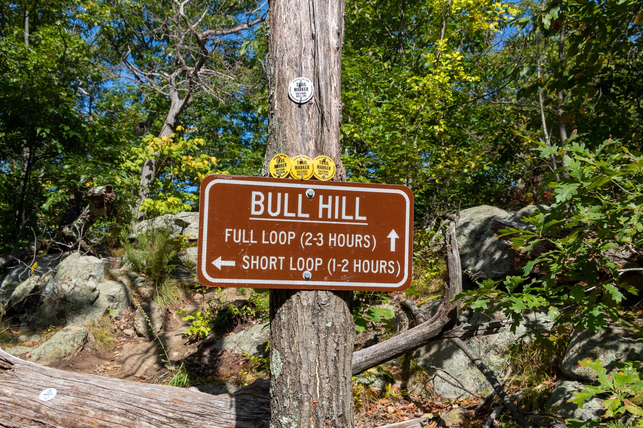

From here, I retraced my steps back down to the intersection and hopped on the yellow marked trail (Short Loop). You could continue on the long loop as well.


Once on the yellow marked trail, there continues to be awesome views such a clear shot of Storm King Mountain.

Follow the yellow marked trail until reaching signage for the red marked trail to connect to. There will be a stream to your right and a bridge to pass. Follow that and the blue marked trail will connect quickly and this will lead you all the way to the parking lot. There will be gradual decline in switchbacks and will become flat pavement for the last mile or so. Along the blue trail, the ruins of the Cornish Estate can be explored as well but this was a very crowded day so I decided to skip that.


This is a fun hike with so many viewpoints and exploration. It is certainly not easy with a lot of steep inclines the first few miles but the views are nonstop you won’t even notice the difficulty. This is definitely one of the better marked trails and there are many trail options to make the hike your own. Fantastic day hike!

HIKING FOR DONUTS
Hi, I’m Mark. I live in Connecticut. I take new trips every chance I get. A good trip has a great hike, great food, and something fun to do. My goal is to search out new trips and share them to inspire others to try something new and exciting.
If you are looking for posts in a particular place, search City or State here.
SEE OTHER POSTS IN ARCHIVE
Archive
RECOMMENDED POSTS


RECENT POSTS


See the latest on Instagram and follow @HIKINGFORDONUTS


Hiking the Breakneck Ridge Trail, New York
Trail Description: The Breakneck Ridge hike is one of the most challenging trails in the Hudson Valley. The mountain is known for rocky terrain, steep rock scrambling, and beautiful views of the Hudson Valley. This trail is immensely popular due to its easy access.
Trail Info:
Where: Cold Spring, NY Distance: 3.7 miles (3.5-4.5 hours) Difficulty: Strenuous Trail Type: Loop Features: Views, River, Mountains, Rock Scrambling
How to get there:
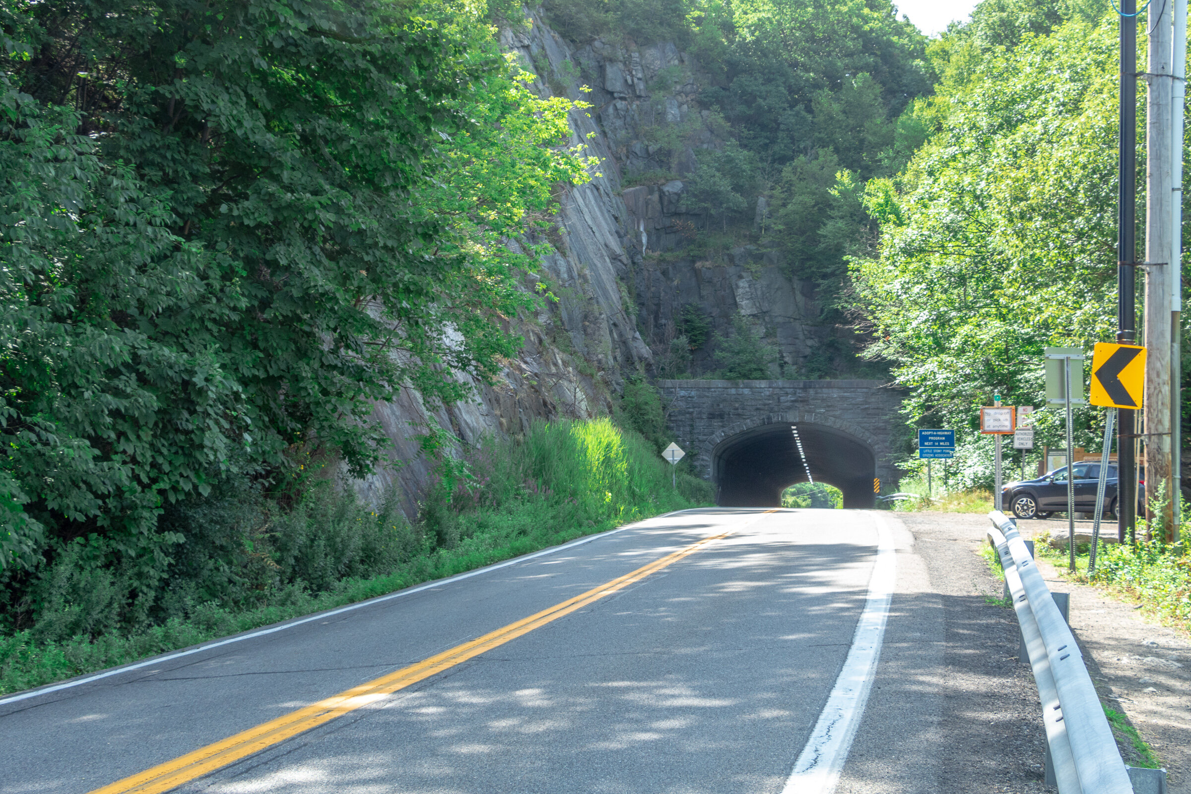
Typing the location “Breakneck Ridge Trailhead” into Google Maps will take you near the parking areas. There are multiple parking spots along State Road 9D, just park where you can north of the tunnel. There is a small lot near the trailhead and a larger lot further down.
For those concerned about parking/driving, this hike is accessible via train. There is a MTA to the Breakneck Ridge train station that is within walking distance to the trail on weekends only.
Hiking Tips
Go on a weekday to avoid the crowds, if possible. Go early on weekends.
Be prepared to rock scramble & use your hands to scale the cliff.
Not dog friendly (unless small dog that you can carry or your dog is a mountain climber)
The Hike
After parking, make sure you are walking along the right hand side of the road. The trailhead starts to the right of the tunnel, where there is trail signage and maps.
There are 3 trail route options for Breakneck Ridge. There is a sign explaining this at the beginning of the trail. The options consist of the short loop (2 hours) ,the regular/classic loop (3 hours), or the trail back to Cold Spring (4 hours). This guide will be the option we took which is the full classic loop.
There is a set of rock stairs that will bring you to the sharp ascent. Follow the white trail markers and start climbing! The terrain on the trail is pretty hard right away. There is a very steep ascent and I needed my hands and knees to get me through this portion of the hike. If you did bring hiking poles, I would suggest securing the poles to your backpack here as they will not be helpful. Depending on your level of climbing up, this can be anywhere from 30 minutes to an hour.

Keep climbing until you reach the flagpole. You will see Pollepel Island with Bannerman’s Castle to your right, along with views of Storm King Mountain straight ahead across the river.


After taking in the views and enjoying a break, continue to follow the white markers as the incline continues. This part is less intense but still some rock scrambling. There is an area in the trail where you can choose to go steeper or take the easier ascent marked with X with an arrow pointing left & right. The easier route was definitely welcomed after the steep climb.

Continue to climb higher and there is another viewpoint with the flagpole far in the distance from above.


Keep climbing until there are no more bluffs and cannot continue further.This is where you head into the forest. The next few miles are much, much easier. You could go back down the way you came but it’s a tough way down and you will be greeted with a traffic jam of many hikers ascending up.

Continue on white markers & ignore the yellow marked trail for now.
There will be a fork eventually. Look for a turn off to the red marked trail (tough to miss red marking on rock). Follow red trail down a gradual descent through woods.

Depending on your pace, the red trail will dead end in about 30-60 minutes where you take left onto yellow trail (Wilkinson Memorial Trail) and keep going downhill and follow all the way to the parking area.


HIKING FOR DONUTS
Hi, I’m Mark. I live in Connecticut. I take new trips every chance I get. A good trip has a great hike, great food, and something fun to do. My goal is to search out new trips and share them to inspire others to try something new and exciting.
If you are looking for posts in a particular place, search City or State here.
SEE OTHER POSTS IN ARCHIVE
Archive
RECOMMENDED POSTS


RECENT POSTS
See the latest on Instagram and follow @HIKINGFORDONUTS