


Hiking Mount Agamenticus, York, Maine
Trail Description: The Mount Agamenticus Conservation Region is located in Southern Maine. The Mount Agamenticus Loop is a popular trail that provides 360 degree views at the summit of the surrounding mountains in the distance.
Trail Info:
Where: York, ME Distance: 1.8m (1 hour) Difficulty: Easy toModerate Trail Type: Loop Features: Views, Mountains, Valley
How to get there:
Typing the location “Mount Agamenticus Trailhead” into Google Maps will take you to the parking lot. You can’t miss it. There is a lot of parking. It’s $2/hr to park and there is a barcode to scan for the app to use to pay. It was easy peasy in my opinion. And, worth the money based on how well they keep up with everything.
Coordinates: 43.21720438450835, -70.69198787482621
Link to google maps location here.
Hiking Tips
I suggest caution if it rained days prior. The trails in the forest are mostly roots and rock. Dry it’s no biggie but wet I don’t think it would be as enjoyable.
Download a copy of the trail map here.
There are multiple trail options. This guide is for the loop via Blueberry Bluff, Witch Hazel, and Ring Trail. The Big A trail has separate parking and is a 1 mile loop that’s mostly gravel & an easier option (stroller and wheelchair friendly).
The trail and parking lots are well maintained and great facilities. Nicest outhouse bathrooms I ever been in!

The Hike
Once parked at the Mountain Road parking lot, the beginning of the trail head is visible with markers at end of the parking lot.

There will be trail signs promptly upon starting the hike at a fork. Stay right and hop on the Ring Trail, which is the white marked trail.

As stated prior, the trail is very well marked. However, the trail is mostly rocks and roots. I saw some reviews mentioning that it was muddy and unpleasant after a rainstorm. And, I totally understand what they meant. The rocks and roots could be slippery. For us, it was dry and there were no issues.

There isn’t much of an elevation gain, only about 340 feet. But there is a small incline as you make your way to the top. Hiking along the Ring Trail, at almost 0.7m, there will be a small foot bridge with a path to the left at the end. This is the Witch Hazel trail. I did not see signs but based on the trail map, this was the way to go.

The Witch Hazel trail is brief. Only a few minutes to reach the Big A Trail. There will also be a small foot bridge.

And following the Big A trail at the top is where the first lookout platform is to take in all the views.

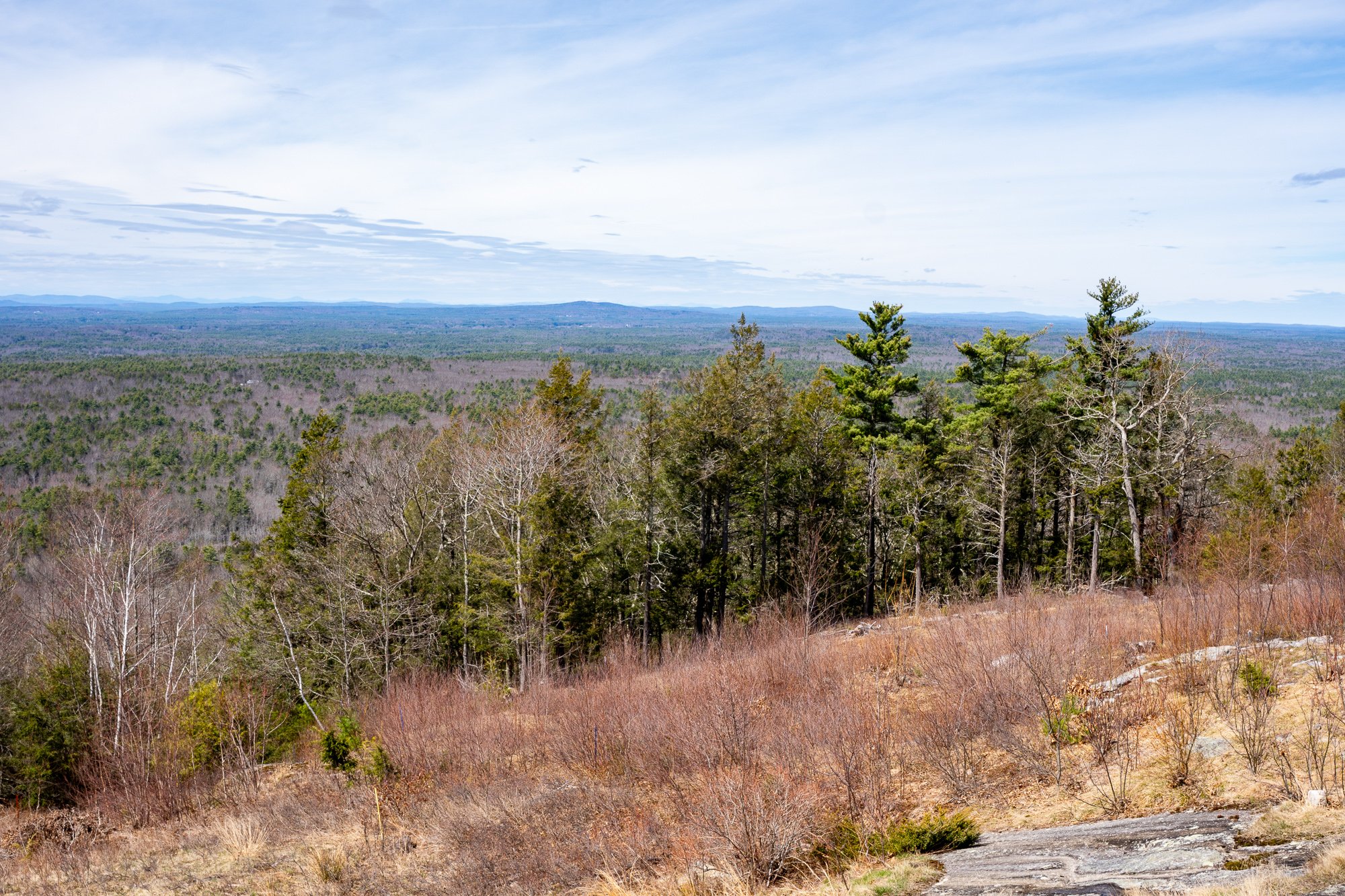
There is another lookout platform with stairs where you can see even higher out into the valley. There is also a fire tower, but it is fenced out and cannot be climbed.


Follow the Big A Trail out until it connects to the Blueberry Bluff, which is marked red. There is also an additional viewpoint here before the Blueberry Bluff.

Continue down the Blueberry Bluff back to the Ring Trail. Take a left at the sign back to the parking lot. You will cross the road at the end to get back to your car.

Southern Maine is tracking to be one of our favorite areas to visit and this was a great first hike in the area. Good hike to get the heart going and see some cool views. The platforms are a cool feature for viewing on the summit. And, the trails and parking lots are so well maintained. I cannot speak highly enough on that. I was not able to find a great guide with details for this hike so I am hopeful this will be helpful for others. It’s also good to see directions/steps before you go to get comfortability. Not a hard hike to follow but I understand where folks can get tripped up. I still do it many times. Luckily, my wife is always the voice of direction.
POST HIKE ACTIVITIES: The fun doesn’t have to stop here. Lots to do in the area. We stopped by the 90s themed brewery, Odd by Nature Brewing, for some post hike beers and nosh, which is about 8 minutes from the trailhead. And, the Nubble Lighthouse is roughly 15 minutes or so away. Definitely a trip to view. Cape Neddick is really cool. Many restaurants in the area as well. No matter what you decide to do, there is a lot to plan for a great weekend or day trip.


HIKING FOR DONUTS
Hi, I’m Mark. I live in Connecticut. I take new trips every chance I get. A good trip has a great hike, great food, and something fun to do. My goal is to search out new trips and share them to inspire others to try something new and exciting.
If you are looking for posts in a particular place, search City or State here.
SEE OTHER POSTS IN ARCHIVE
Archive
RECOMMENDED POSTS


RECENT POSTS


See the latest on Instagram and follow @HIKINGFORDONUTS

How to Hike The Beehive Trail, The Bowl, & Champlain Mountain, Acadia National Park
Trail Description: This hike climbs The Beehive via cliffs and iron rungs that leads to The Bowl (a pond), and then climbs up to the summit of Champlain Mountain. There are amazing views from the summits and various spots on the trail.
Trail Info:
Where: Bar Harbor, ME, Acadia National Park Distance: 4.9 miles (5-6 hours) Difficulty: Strenuous Trail Type: Loop Features: Views, Mountains, Water, Pond, Cliffs, Summit
How to get there:
Sand Beach Parking lot in Acadia National Park. There are restrooms here. In addition, there is beach access and other hiking trails.
Hiking Tips
If you have a fear of heights, the Beehive Trail is not recommended for you.
If it has rained recently and the trail is very wet, I would recommend not including the steep climb portion of the Beehive Trail on that day.
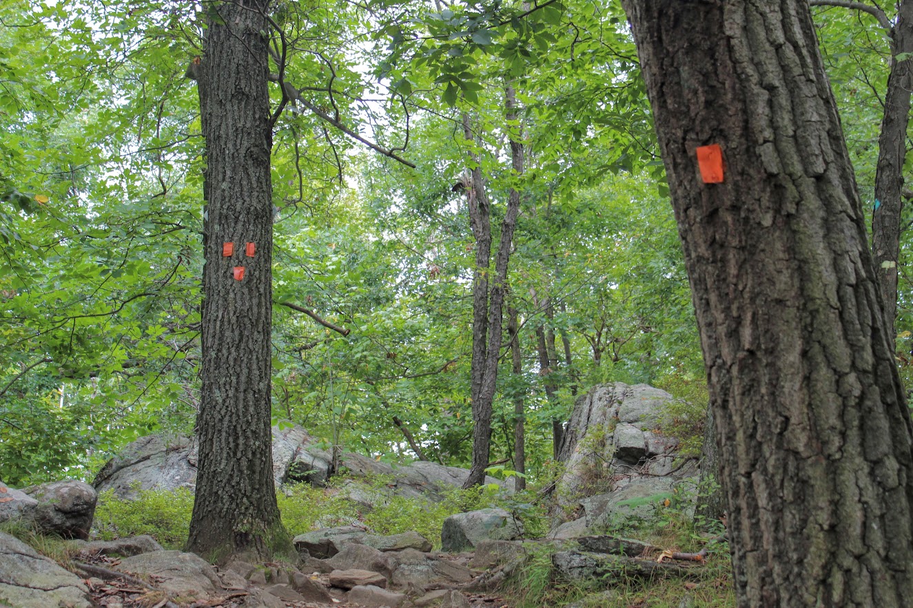
Be sure to take this loop trail counter-clockwise. You do not want to climb down the irons rungs nor clog up traffic.
This is the one of the most popular hikes. It will be very busy, start early!
The Hike
The Beehive loop hike at Acadia National Park is probably #1 on most tourists' itinerary. This is a short and steep hike with some exhilarating but dangerous sections using iron rungs to climb up the side of the mountain. The hike is not for the faint of heart. The experience alone makes this a bucket list adventure. So, of course, it was one of my top priorities visiting Acadia for the first time. My wife and I went for a few days last fall. Due to time constraints, I needed to ensure I got the best bang for my buck. Luckily, The Beehive trail intersects with the Bowl which connects to the trail that summits Champlain Mountain. Now, you could do all 3 of these separately but this was a no brainer. This allowed my wife and I to see more amazing views in the allotted time we had.
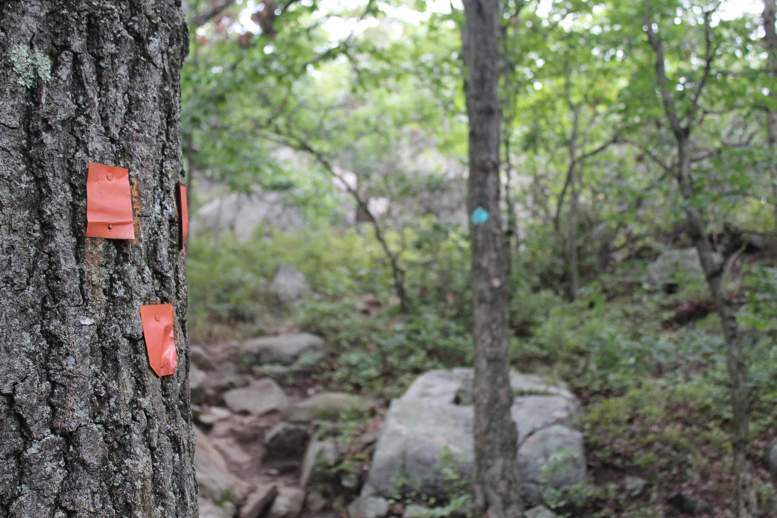
The trailhead is located on the opposite side of the street, about 100 yards across from the Sand Beach parking lot. From the parking lot, start heading on the gravel path to the right of the parking lot entrance as you walk up to Park Loop Road. Cross the road and the trailhead for the Bowl Trail will be right there. Just follow the crowd! The trail is flat but rocky to start. After 0.2m turn right onto the Beehive Trail where Bowl Trail goes straight. Follow the blue blazed trail.
This is where the climbing begins. First are the short staircases. Then, there are a few narrow ledges with sheer drops. Followed by climbing iron rungs used to assist in the ascent up the vertical rocks. All completely exposed. You have some options here if you are not comfortable going up the Beehive Trail using the iron rungs. There is an option to access The Beehive from the backside or skip it entirely and choose to head to The Bowl. I enjoyed this as it was challenging and thrilling. And, the views were awesome. However, it is not to be taken lightly. It is dangerous. Take your time and be thoughtful to your fellow hikers. This part of the hike is relatively short.


At around 0.6m, we reached the summit of the Beehive Trail and enjoyed some amazing views of Sand Beach and Great Head. The hard work is worth it!
Continuing on the blue blazed trail, go straight through an intersection where a connecting trail leaves left. At 0.9m, this is where we reached the shore of a pond, known as The Bowl.
Follow the path with the wooden boards on the left along the shoreline for 0.1m to split in the trail. The Bowl goes left and Champlain South Ridge Trail will veer to the right. Take the right and follow Champlain South Ridge Trail. The sign indicates 1.6m to Champlain Mountain from here. There is an amazing view of The Bowl as you hike higher up the mountain.
Be weary of the blue markings along the trail and follow the cairns. There are more spectacular views at the summit of Champlain Mountain. This summit is less hectic than the Beehive so this is a good spot to have a snack and relax.


After soaking in the views, retrace your steps down to The Bowl. There are four paths leaving the summit, ensure you are heading the direction you came up. Once you get down to The Bowl intersection, bear right away from the pond and take the rest of the trail back to Park Loop Road for about 0.8m. You will pass two trails on the right leading up to Gorham Mountain and two trails on the left heading to the Beehive. Just keep going straight at all intersections.

This will lead you back to where you started. As mentioned above, we decided to combine all three trails so we can see more. I would highly recommend this particular loop in this fashion. Lots of great views. Amazing hike. The Beehive hype is real. Bucket list checked off.
HIKING FOR DONUTS
Hi, I’m Mark. I live in Connecticut. I take new trips every chance I get. A good trip has a great hike, great food, and something fun to do. My goal is to search out new trips and share them to inspire others to try something new and exciting.
If you are looking for posts in a particular place, search City or State here.
SEE OTHER POSTS IN ARCHIVE
Archive
RECOMMENDED POSTS

RECENT POSTS
See the latest on Instagram and follow @HIKINGFORDONUTS


Storm King Mountain, New York
Storm King Mountain State Park Trail Guide (Cornwall-On-Hudson, NY)
If you are looking for a great hike with awesome views in the Hudson Valley, Storm King Mountain is one of the best hikes in the area. The trail will get your heart pumping but you will be amazed at the summit view from the top.
Trail Description: Storm King Mountain offers one of best views in the Hudson Valley. The hike includes an initial steep hike to the top of Butter Hill, but the gratifying views at the top are worth the effort.
Trail Info:
Where: Storm King Mountain, Cornwall, NY Distance: 2.7 miles (2.5-3 hours) Difficulty: Moderate to Difficult Trail Type: Loop Features: Ruins, Mountains, Views, River, Views, Bridge
How to get there:
Heading south on Rt 9W from Newburgh, cross under the overpass for Angola Road. You will begin climbing a hill (in your car!) and on your left you will the parking lot for the Storm King Mountain. However, you can’t make a left here because it is an illegal turn. Continue driving a few miles until reaching the exit at Rt 218/Rt 293. Get back on Rt 9W and circle back to the parking lot. If you type in this address: 1750 US Rte 9W, Cornwall=on-Hudson, NY 12518, this should sufficient enough for the GPS.
Hiking Tips
Get there early for a less crowded trail.
Start on the orange trail in the beginning (not the white trail).
Pay close attention to when markers change colors
Bring hiking poles
THE HIKE
During the summer, I made a list of hikes I wanted to accomplish by the end of the year. Somehow, some way I was going to make them happen. I wanted to end the year hiking awesome and challenging trails. Storm King Mountain was high on my list. I came across this hike first on Instagram, of course. The pictures looked stunning. Since I do frequently travel to the Hudson Valley area, all I had to do was make the time. The hike does look intimidating but it wasn’t that bad. I would have liked better weather on this day, as it was a tad cloudy with overcast. But, the hike was really fun and awesome views nonetheless.
View from the parking lot.
This hike is really popular. Get there earlier or try a weekday if you can. There were already a lot of cars and a shuttle bus of tourists by 930am. After we got our gear ready, the trailhead was to our left facing the woods. We saw the white trail on our right. I read hopping on the orange trail was the way to go. And, that was 100% accurate. It is more difficult in the beginning but I rather have fresher legs climbing up. The orange trail starts off steep right away. I found this part super fun. It was strictly a steep incline climbing up. The rocky path was taking us up to Butter Hill. Looking back, we witnessed some cool views of the highway as it started to disappear.


First of many views on the hike.
Model climber.
Once all the climbing was done, we reached some small ruins. Keeping the orange markers in our sights, we continued up toward Butter Hill. A little more views started to appear. There is an important decision to be made on the trail. The Orange Trail abruptly ends as the blue Yellow Trail markings appear (you will see blue marking first) . Turning right at this junction, lead us on the correct path. I have read this is a point in the hike where people take a left and get lost. One more time, turn RIGHT when the Orange Trails ends or your day hiking will be regretful.
Ruins.
highway overlook.
We reached Butter Hill in about a half an hour from the start of the hike. This is the highest point of the hike at 1,375 feet. Continuing forward there still was some uphill stretches as the blue/yellow trail moseys across the mountain. There are intersections where the blue/red marked trail is on your left. However, you want to turn right on the blue/yellow trail you will see a small cairn. It is easy to get off track with all the intersecting trails. You will see a blue-blazed, don’t fall for it. Just stick to blue/yellow trails at this point.
Continuing around the mountain….
turn right toward the yellow blue trail.
From here, the hike took us to the northern end of Storm King Mountain. Not quite the money shot view. Just a little tease of what it is next .
almost there.
A little bit past this spot, we reached a rocky field in the open and BOOM. Stunning landscape. There are wide views of Newburgh Bay, Bannerman’s Castle, and the Newburgh-Beacon Bridge. On a clear day, the Catskills are visible. We could see some sail boats in the Hudson River as well. A very cool summit view.
newburgh bay.
this is why you hike this trail.
After taking an excessive amount of pictures, we hopped back on the blue/yellow trail. Going down, we noticed some more cool overlooks on our left looking at the town of Cold Spring and getting a smaller glimpse of the summit view. I recommend taking a look. Shortly after the awesome view, the White Trail markers will appear. Taking a sharp left around the mountain with a U-turn, we started on the White Trail. And soon after, the trail will be blazed with blue and white markers. BUT, then the blue markers will fade and this goes back to only white markers. And now, the white markers will take you back to the parking lot. There is one last steep uphill climb before the parking lot to give you a nice good-bye and keep your heart pumping.
Views of cold spring as you hike down.


That's what I call a bang for your buck hike. The hike was very challenging, the hike wasn't too long, and there a multiple magnificent views for photo opportunities. And, I had a blast hiking it. The trail route we took was about 2.7 miles and took us under 3 hrs, including probably 30 mins of me taking pics. There are some very steep inclines but nothing your average hiker can't overcome. As long as you start the hard way first, the hike ain't so bad. This is one of the best hikes in the Hudson Valley hands down. I am happy to check this off the list, but now I want to go back!
Amazing.

HIKING FOR DONUTS
A blog for the outdoors foodie enthusiast
Hi, I’m Mark. I live in Connecticut. I take new trips every chance I get. A good trip has a great hike, great food, and something fun to do. My goal is to search out new trips and share them to inspire others to try something new and exciting.
If you are looking for posts in a particular place, search by city or state here.
EXPLORE OTHER POSTS IN THE ARCHIVE
Archive
RECOMMENDED POSTS


MOST RECENT POSTS
See where I have been recently on Instagram. Follow @HIKINGFORDONUTS